All Activity
- Past hour
-
Christmas miracle

-
Christmas miracle
-
AI says that D.C. received 5 - 7 inches of snow from that storm. https://search.yahoo.com/search?p=1969+christmas+snow+in+D.C.&fr=yfp-t&fr2=p%3Afp%2Cm%3Asb&fp=1
-
Snow continues here. Maybe 2" on unpaved surfaces. 1" on paved surfaces. Road covered again after plow came by an hour ago. Will go shovel driveway in a bit. 32
-
Not hating the Christmas miracle storm either.
-
Brick sidewalks are a literal death trap in Portland right now. Almost just died getting home from work, had to shuffle walk like a duck. 32 and light rain.
-
Strong gusts in Asheville with showers
-

Minor snow possible sunday 12/14/25
Krs4Lfe replied to WeatherGeek2025's topic in New York City Metro
Looking less and less likely that this will be a “plowable” snowfall. Looks like a minor event at best. Maybe when the cold air relaxes we can get something larger. But then again it’ll probably be too warm to snow -
I'm not sure how much it has affected the UHI but the city skyline has changed a lot in the past 20 or so years. Many more skyscrapers, Western Brooklyn and Queens are like a continuation of Manhattan. So I would think this would have at least some affect on the UHI
-

Minor snow possible sunday 12/14/25
WeatherGeek2025 replied to WeatherGeek2025's topic in New York City Metro
sorry i'm a noob -

December 2025 regional war/obs/disco thread
TauntonBlizzard2013 replied to Torch Tiger's topic in New England
Blek -
It’s lake effect raining now. I hate it. Makes me angrier than Beavis during an El Niño winter.
-
About 3 inches down and snowing at a good clip, half way to my Wish-cast of 6".
-
Not the most important part of the region though.
-

December 2025 regional war/obs/disco thread
Snowcrazed71 replied to Torch Tiger's topic in New England
ok... So not horrible ( especially that it's a map from the NWS ).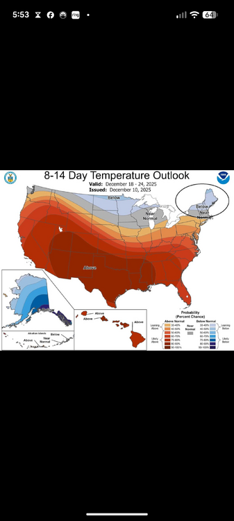
-
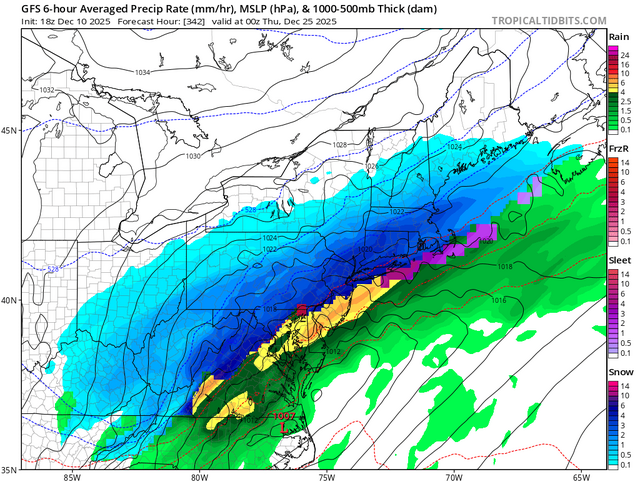
Just issued- Special Weather Statement National Weather Service Blacksburg VA 540 PM EST Wed Dec 10 2025 VAZ019-020-WVZ507-110600- Alleghany VA-Bath-Eastern Greenbrier- Including the cities of Clifton Forge, Covington, Hot Springs, Lewisburg, White Sulphur Springs, and Alderson 540 PM EST Wed Dec 10 2025 ...BURSTS OF HEAVY SNOW POSSIBLE THIS EVENING AND OVERNIGHT... Bands of heavy snow are possible this evening through the overnight hours. Heavy snow and strong wind gusts could significantly reduce visibility in a short time, and lead to dangerous driving conditions. Temperatures dropping below freezing will allow for snow to quickly accumulate on roadways during the overnight hours, and roads may be slick, especially ones that are untreated. If traveling and encountering adverse driving conditions, reduce speed, ensure headlights are on, and leave plenty of room between you and other vehicles. Special Weather Statement National Weather Service Baltimore MD/Washington DC 222 PM EST Wed Dec 10 2025 MDZ501-502-VAZ504-WVZ502>504-506-110300- Extreme Western Allegany-Central and Eastern Allegany- Eastern Highland-Eastern Grant-Western Mineral-Eastern Mineral- Eastern Pendleton- Including the cities of Frostburg, Cumberland, Monterey, Petersburg, Elk Garden, Antioch, Keyser, New Creek, Ridgeville, Russelldale, Headsville, Fort Ashby, Brandywine, Franklin, Oak Flat, Ruddle, and Sugar Grove 222 PM EST Wed Dec 10 2025 ...BURSTS OF SNOW POSSIBLE BETWEEN 5 AND 10 PM... Bursts of snow are possible between 5 and 10 PM this evening. Affected locations will see rapidly changing weather and road conditions, with brief heavy snow and gusty winds. A quick snow accumulation up to an inch is possible. PRECAUTIONARY/PREPAREDNESS ACTIONS... Be prepared for areas of blowing snow. This could lead to temporary whiteout conditions and the potential for dangerous driving conditions. If you are traveling and encounter adverse winter driving conditions, reduce speed and make sure headlights are on.
-
1". Pingers now. 28f Sent from my SM-S921U using Tapatalk
-
^Actually not bad for a good portion of the region.
-
HH GEFS kinds likes it lol
-
The HRRR was a few degrees too warm in Orange and Putnam. A coating of snow down to nearly river level with accumulations increasingly quickly with elevation. Turned into a snowy evening with snow mixing in at 500ft in Morris County right now. The less snowy NAM runs appeared to do better than the HRRR or RGEM which showed mostly rain until well NW. Actually the ECMWF and GFS did pretty good with the lower level temp profile too I think.
-
18z gefs mean is east with it like the op.
-
December 2025 regional war/obs/disco thread
TauntonBlizzard2013 replied to Torch Tiger's topic in New England
Guess that’s a decent sign. I saw the Ukie earlier and thought it could blow it up a little, but it didn’t -
Next time you take a screenshot can you make the L and pressure number larger? Thx in advance.
-
If you want some tiebreakers, the 12z ggem, 12z ukie, and 18z rgem all held it back over the Great Lakes as well.
-

December 2025 regional war/obs/disco thread
Baroclinic Zone replied to Torch Tiger's topic in New England
Balmy 50F


