All Activity
- Past hour
-
Mostly graupel falling. Ashburn
-
Records: Highs: EWR: 62 (1990) NYC: 63 (1990) LGA: 59 (1990) JFK: 55 (1973) Lows: EWR: -7 (1982) NYC: -2 (1977) LGA: -1 (1982) JFK: -1 (1982) Historical: 1817 - A luminous snowstorm occurred in Vermont and New Hampshire. Saint Elmo's fire appeared as static discharges on roof peaks, fence posts, and the hats and fingers of people. Thunderstorms prevailed over central New England. (David Ludlum) 1837: The green flash was apparently first documented by Captain Back of the H. M. S. Terror while in the arctic during its expedition of 1836-1837. He wrote: 'In the morning however, at a quarter before ten o'clock while standing on an ice hummock about 17 feet high, and looking toward the east, I had observed the upper limb of the sun, as it filled a triangular cleft on the ridge of the headland, of the most brilliant emerald color, a phenomenon which I had not witnessed before in these regions.' (Ref. AccWeather Weather History) 1857: The Famous “Cold Storm” paralyzed areas from North Carolina to Maine. One to two foot snowfalls were the norm rather than the exception. 20 foot drifts were reported in Norfolk, VA. Temperatures were below zero from Virginia northward. At Cape Henry, NJ, one could walk out 100 yards on the frozen ocean. The Chesapeake Bay was frozen out to a mile and one-half from shore. (Ref. AccWeather Weather History) 1867: A severe wind and snowstorm paralyzed the Northeast with 12 inches of snow and hurricane force winds. The old colony railroad was snow bound for 10 days. (Ref. Wilson Wx. History) 1893 - The mercury dipped to 17 degrees below zero at Millsboro, DE, to establish a state record. (The Weather Channel) 1899: Chicago had its LATEST one inch or more snow in its winter season on this date. Snow Trivia for Chicago - NWS 1916: Reno, Nevada, received 22.5 inches of snow, its greatest 1-day snowfall total ever. 1943: The maximum temperature for the date in Washington, DC is 72°F (Ref. Washington Weather Records - KDCA) 1972 - A single storm unloaded 77.5 inches of snow at Summit, MT, to establish a state record. (The Weather Channel) 1982 - Strong chinook winds caused severe wind damage in Boulder, CO. Wind gusts to 118 mph was recorded on the roof of the Environmental Research Laboratories (ERL), and a wind gust to 137 mph was measured atop the roof of the NCAR building (in the southwest part of the city, 600 feet above ground level). The high winds uprooted trees and damage roofs. (Storm Data) 1982: The "Cold Sunday" in the United States occurred as high pressure covered the U.S. east of the Rockies, and was centered over Kentucky to Arkansas at 1032 millibars or 30.47 inches of mercury. Tower, MN was the cold spot in the nation with -52° and International Falls, MN following closely behind with a record low of -45°. Danville, IL set their all-time record low with -26°. New January records were set at Milwaukee, WI at -26° their coldest in 111 years and Buffalo, NY with -16°. Philadelphia, PA tied their January record low with -7°. Chicago, IL and Pittsburgh, PA set daily record lows with -23° and -18° respectively. The record low of -5° at Washington, DC was their coldest reading since 1934. (Ref. Wilson Wx. History) (Ref. AccWeather Weather History) 1987 - A winter storm spread snow from the Southern Rockies into the Middle Mississippi Valley and southwestern sections of the Great Lakes Region, and freezing rain across Texas and oklahoma. Snowfall totals ranged up to 16 inches at Tulia TX, with 12 inches at Wellington KS. (National Weather Summary) (Storm Data) 1988 - A Pacific storm battered the southern coast of California. Winds gusting to 65 mph uprooted trees in San Diego. Los Angeles reported an all-time record low baromteric pressure reading of 29.25 inches. (National Weather Summary) (Storm Data) 1989 - Strong chinook winds along the eastern slopes of the Rockies gusted to 90 mph near Rollinsville CO, and reached 94 mph near Big Timber MT. Heavy snow blanketed parts of the Upper Mississippi Valley, with eight inches reported in Douglas County WI. (National Weather Summary) (Storm Data) 1990 - Twenty cities across the southeastern half of the country reported record high temperatures for the date. Record highs included 61 degrees at Williamstown PA and 85 degrees at Brownsville TX. Evening thunderstorms produced large hail and damaging winds from eastern Texas to Mississippi. (National Weather Summary) (Storm Data) 1994: Louisville, KY recorded 15.9 inches of snow in 24 hours for not only its greatest 24 hour snowfall ever, but also its greatest snowstorm ever up to that time, as a massive overrunning pattern developed over the frigid arctic air that was entrenched across the eastern U.S. Lucasville, OH was buried under 30 inches and up to 23 inches was reported in Robertson County, Kentucky. Freezing rain created half an inch of ice in central and southern Indiana the previous day. It then changed over to snow on this date and dropped over a foot of snow in some places. Harrison, Clark, and Floyd Counties reported 16 inches of snow. (Ref. Wilson Wx. History) Serious drifts! High NW winds caused whiteout conditions in Northeast SD. A snowplow train with 3 locomotives became trapped in drifts east of Lake Preston; the crew was rescued by snowmobile on the 18th. Also, 3 train engines were stuck in a drift E of McIntosh.(Ref. Weather Guide Calendar with Phenomenal Weather Events 2011 Accord Pub. 2010, USA) 1996: Snowfall accumulations of 2 to 15 inches, high winds from 40 to 60 mph, and cold arctic air resulted in blizzard conditions and extreme wind chills from -40° to -70° across central, north central, and northeast South Dakota as well as west central Minnesota from the middle morning through the early evening of the 18th. Most schools, federal, state, and county offices were closed. Also, various activities were canceled. Travel was extremely difficult due to the near zero visibility with some vehicles stranded. Highway 12 from Webster to the Minnesota border and Interstate 29 was closed on the 18th. Hundreds of people were stranded with some people stranded in their vehicles. Some snowfall amounts included: 15 inches occurred at Wheaton, Clinton, and Graceville, 12 inches at Wilmot, Rosholt, and Ortonville, Minnesota, 10 inches at Eureka and Britton, 9 inches at Mellette, Aberdeen, and Redfield, 8 inches at Doland. The extreme wind chills along with some blowing snow continued across central and north central South Dakota into the early evening of the 18th. High winds behind the powerful low pressure system battered west Texas and parts of eastern New Mexico. Sustained winds hit 105 mph with gusts to 128 mph at Guadeloupe Pass, TX. Wind gusts reached 89 mph at White Sands, NM and 75 mph at El Paso, TX. One person was killed and 3 others were injured when the high winds collapsed a Supermarket roof in Anthony, TX. El Paso, TX recorded its lowest barometric pressure ever with 29.22 inches of mercury. (Ref. Wilson Wx. History)(Ref. AccWeather Weather History) 1999: An F4 tornado tracked across southern Jacksonville, Tennessee, damaging more than 200 homes and 55 buses. The storm killed six people and injured 106. 2010 - A series of strong Pacific storms impacted Arizona, California, Colorado, New Mexico, Nevada and Utah from January 17th through 23rd, leaving behind several feet of snow across the higher terrain and breaking numerous lowest barometric pressure records across the region. Sunrise Mountain, Arizona received 77 inches of snow, while Mammoth Lakes, California received 90 inches. (NCDC) 2016: A potent storm system developed and tracked quickly eastward across the Gulf of Mexico and toward Florida on Saturday, January 16, 2016. The impacts from this storm reached west-central and southwest Florida during the early morning hours of Sunday, January 17, 2016. A squall line of strong to severe thunderstorms, just ahead of the cold front, produced periodic wind damage and isolated tornadoes as it quickly moved ashore across west-central and southwest Florida and pushed across the state. Two EF2 tornadoes touched down, one near Siesta Key in Sarasota County and the other near Duette in Manatee County. Two adults were killed and four others injured when their mobile home rolled over and was destroyed by the tornado in Manatee County.
-

First Legit Storm Potential of the Season Upon Us
SouthCoastMA replied to 40/70 Benchmark's topic in New England
Haven't looked at 925 temps but euro prefip algo showed rain for a good chunk, here -
New SREF
-

E PA/NJ/DE Winter 2025-26 Obs/Discussion
Kevin Reilly replied to LVblizzard's topic in Philadelphia Region
Looks like we are picking up on a modest event here on Monday. To me looks like we may be heading into a pattern where we will be saying over the next two weeks. "It just likes to snow here." -
We’re probably about to have a healthy 12z nam
-

First Legit Storm Potential of the Season Upon Us
moneypitmike replied to 40/70 Benchmark's topic in New England
I can picture it already.......seeing me in green with "mostly rain" scrawled through it. -

First Legit Storm Potential of the Season Upon Us
Damage In Tolland replied to 40/70 Benchmark's topic in New England
Like a fart ? Did you have to let it linger -
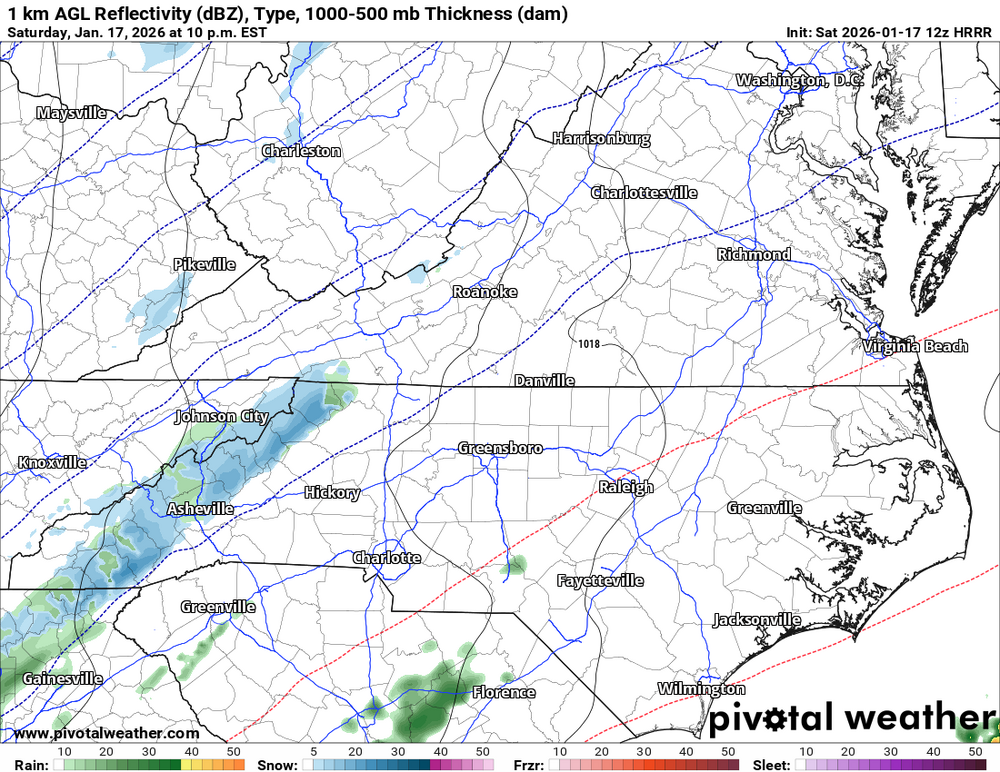
12Z HRRR has a nice strip of moisture developing over WNC tonight around 9-10pm. This seems to have some legs here. Perfect timing for snow to accumulate.
-

First Legit Storm Potential of the Season Upon Us
WinterWolf replied to 40/70 Benchmark's topic in New England
Ahh ok. Us out here WOR need a few ticks west for sure. Hope that happens. -

First Legit Storm Potential of the Season Upon Us
CoastalWx replied to 40/70 Benchmark's topic in New England
Yeah. Some models also tried lingering it into Monday too. -
E PA/NJ/DE Winter 2025-26 Obs/Discussion
Kevin Reilly replied to LVblizzard's topic in Philadelphia Region
That's a pretty healthy band of snow basically Delaware County / Chester County line points west. Saw the Cams out of Chester and Lancaster County and it is coming down at a pretty good clip that stays there or slowly moves east that could put down a quick 1-2". I would think we are getting close to issuing a winter weather advisory for most places I-95 points west and northwest. All of this is inching eastbound and will over time. -
First Legit Storm Potential of the Season Upon Us
CoastalWx replied to 40/70 Benchmark's topic in New England
No offense to you and others, but you all have had a few bones thrown away the last several years. The only thing I have thrown my way was Kevin’s Weedwhacker up my fanny. -
12z Hrrr at 17hrs looking further west than 0z.
.thumb.png.5a2ab2ff8d1d26b124299cc99950fa6c.png)
-

Pittsburgh/Western PA WINTER ‘25/‘26
colonel717 replied to Burghblizz's topic in Upstate New York/Pennsylvania
Not sure how much compaction occurred with the brief mix we had but definitely at least 2 inches. So I think that was an over performer. Most were calling for .5 to 1 inch over night for part 1. NAM was horrible. Canadian was best that I could tell. Nice that we had high moisture content. doesn't subliminnate as quick so want to keep this around until late next week. Not sure when the snow squalls are supposed to come today.
-

E PA/NJ/DE Winter 2025-26 Obs/Discussion
Hurricane Agnes replied to LVblizzard's topic in Philadelphia Region
The 6z 3k NAM and EC are throwing a few inches at the Philly metro area.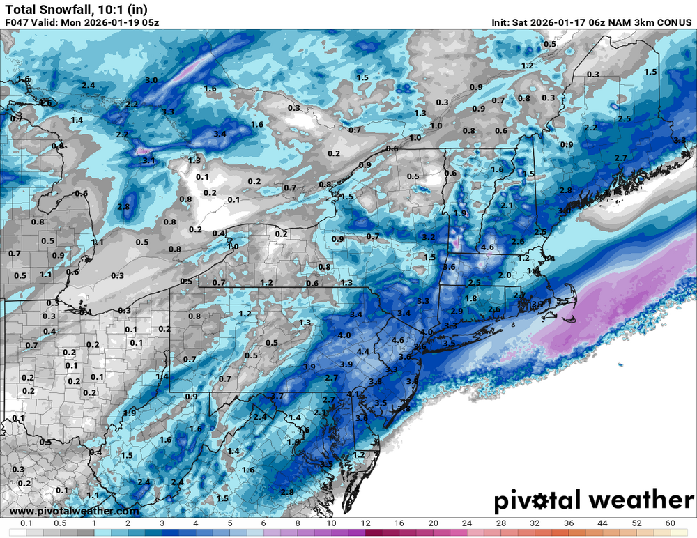

-
January 17 1996: A severe ice storm hits the western and northern Twin Cities with accumulations between a half an inch and an inch. A foot of snow fell over central Minnesota. 1982: The citizens of Tower wake up to a frigid low of -52 degrees F.
-
First Legit Storm Potential of the Season Upon Us
Damage In Tolland replied to 40/70 Benchmark's topic in New England
Looks like this comes in tomorrow afternoon and heaviest is into the night? -
The 6z was a pretty unanimous move to the west/NW.
-
First Legit Storm Potential of the Season Upon Us
CoastalWx replied to 40/70 Benchmark's topic in New England
I’d like to have several inches of man paste hopefully with the snow. I don’t want fluff. I’m done with that and now it’s almost an angle season. -

2025-2026 Fall/Winter Mountain Thread
Buckethead replied to Buckethead's topic in Southeastern States
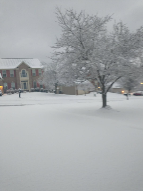
It's a beautiful blue morning up here! I'm guessing that the blue appearance is due in part to the high moisture content of the snow. Sent from my Pixel 10 Pro using Tapatalk -
First Legit Storm Potential of the Season Upon Us
WinterWolf replied to 40/70 Benchmark's topic in New England
Nothing coming easy for us the last 4-5 years that’s for sure. But we seasoned now, we hardened, and we push on…we are New Englanders. -

First Legit Storm Potential of the Season Upon Us
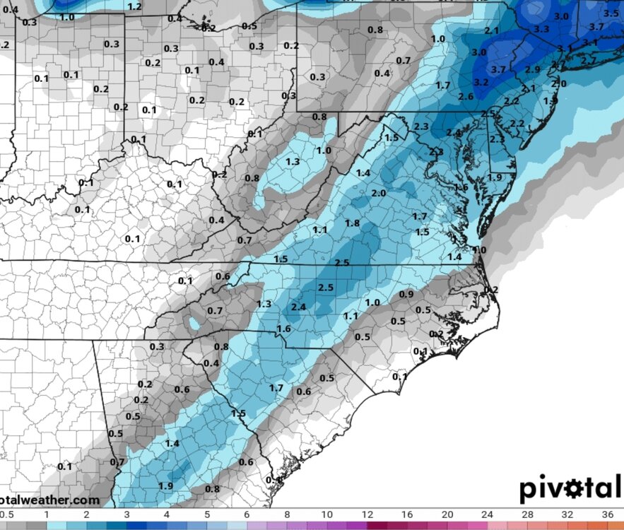
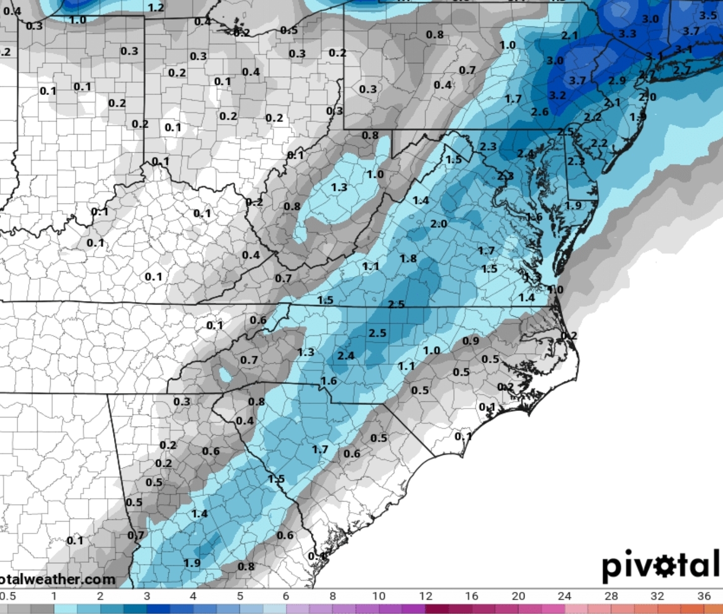
40/70 Benchmark replied to 40/70 Benchmark's topic in New England
I'll do a revised map tonight. -
First Legit Storm Potential of the Season Upon Us
CoastalWx replied to 40/70 Benchmark's topic in New England
No, I’m not saying a total reverse, but if I see things start moving east that’s gonna be disappointing. I’d like to see a continue ticking west right up to game time. I think for me I’m going to need the rates so I’d like to see some meat in this. -
First Legit Storm Potential of the Season Upon Us
moneypitmike replied to 40/70 Benchmark's topic in New England
One can save a lot of time in their day if they simply look to see how the post/page count has changed on a storm thread. The obs threads are always trainwrecks. lol


.png.8629ffe45aa58b0f1e31b5c0b262c801.png)


