All Activity
- Past hour
-
.
-

-
 Legitimately the beef I been silently fuming over all morning Sent from my SM-S166V using Tapatalk
 -
This is correct. Can’t tell ya how I know (some of you in here may know what I do for a living) What I can tell you is it’s something that’s being worked on.
-
 no, that's what Dendrite looks like.
 -
No idea. But I agree it’s absurd
-
National blend of weenies model!
-

January 2026 Medium/Long Range Discussion
IUsedToHateCold replied to snowfan's topic in Mid Atlantic
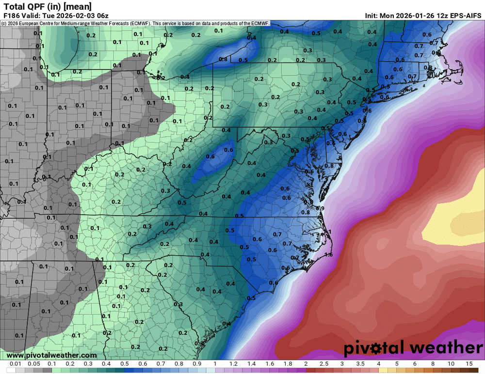
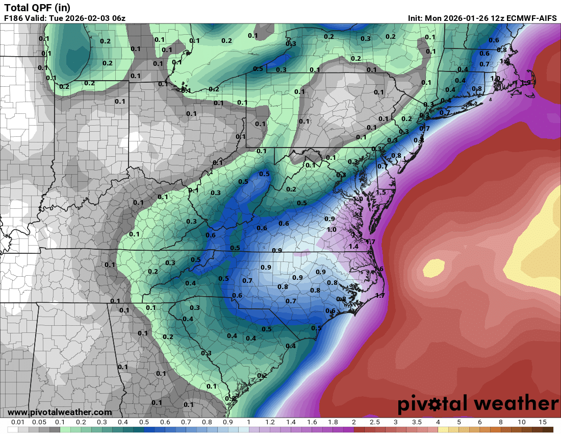
Based upon their performance this past weekend, my guess is that they're powered by AI or something. It's reading the QPF map and the temperature and saying "2 feet of snow!" without analyzing the midlevels, or it is analyzing the midlevels and coming up with something wildly wrong. -
yeah thats true, i gotta wait till tomorrow to get COOP/cocorahs for snowfall today. that map refreshes frequently which is nice. just wanted to know your thoughts on the 21.4 for blue hill
-
 Another 0.6" since this morning. 18.4" storm total. 1.75" SWE
 -

The “I bring the mojo” Jan 30-Feb 1 potential winter storm
olafminesaw replied to lilj4425's topic in Southeastern States
Euro AI and AI EPS are both looking really good
-
thats official COOP. its on the BOX climo page, long standing official climo spot. was extremely cold shouldnt have made a diffreence
-
People just believe it too. My friend called it a “forecast.”
-
I cleared once at 10:00am, then again at 5:00pm or so. Technically, my 10.1 is a tenth or 2 too low. My actual snow total was 6.7”. Sleet was at minimum 3.5”, but I screwed up my hourlies and didn’t fix it lmao. You’re good for 10.0”. Peak depth was 8.5” during dumping sleet so that lends credibility to 10”+ too.
-

The “I bring the mojo” Jan 30-Feb 1 potential winter storm
HKY_WX replied to lilj4425's topic in Southeastern States
The JMA is in our corner (aka the standard bearer).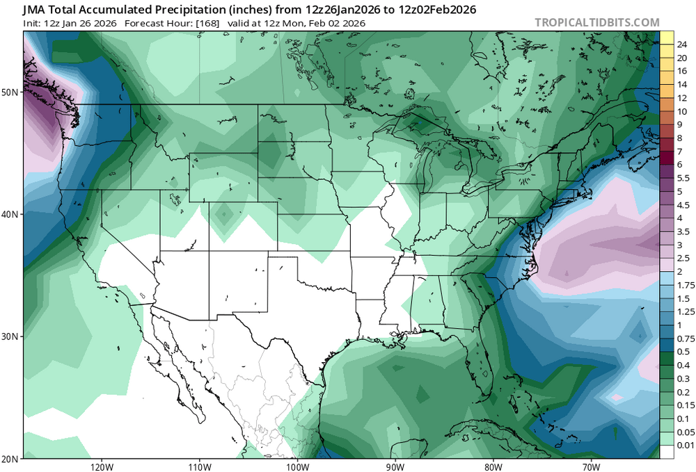
-
The signal is there, and there’s lots of model agreement on a potential Miller A. That's all I really care about until we get to Wednesday. Then we can start ironing out the smaller details (placement, strength, etc)
-
Hi, so this isn't to stir up anything but I just wanted to address this post and a couple others. I know there have been issues in the past at DCA but the current SWO there isn't the one from the past. The current SWO is a former coworker of mine who I helped train to observe. I trust his number fully as he worked 2 shifts over the weekend as well. The microclimate of the Potomac River Valley does play here though. I wouldn't expect DCA to have as high of a value as IAD or BWI considering their locations. I just wanted to help address this issue a bit since I know some of the information and I have seen what has been done there in the past with respect to snow measuring.
-
 That map also has old numbers
 -
Was really cold. I don’t think that would matter. im not saying they slanted, but I know when its windy they have had what seems to be higher readings.
-
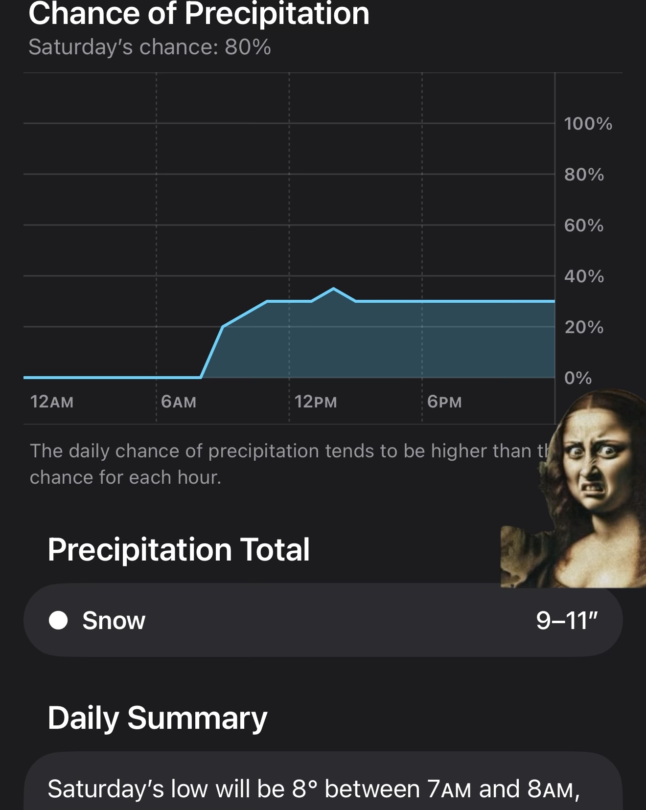
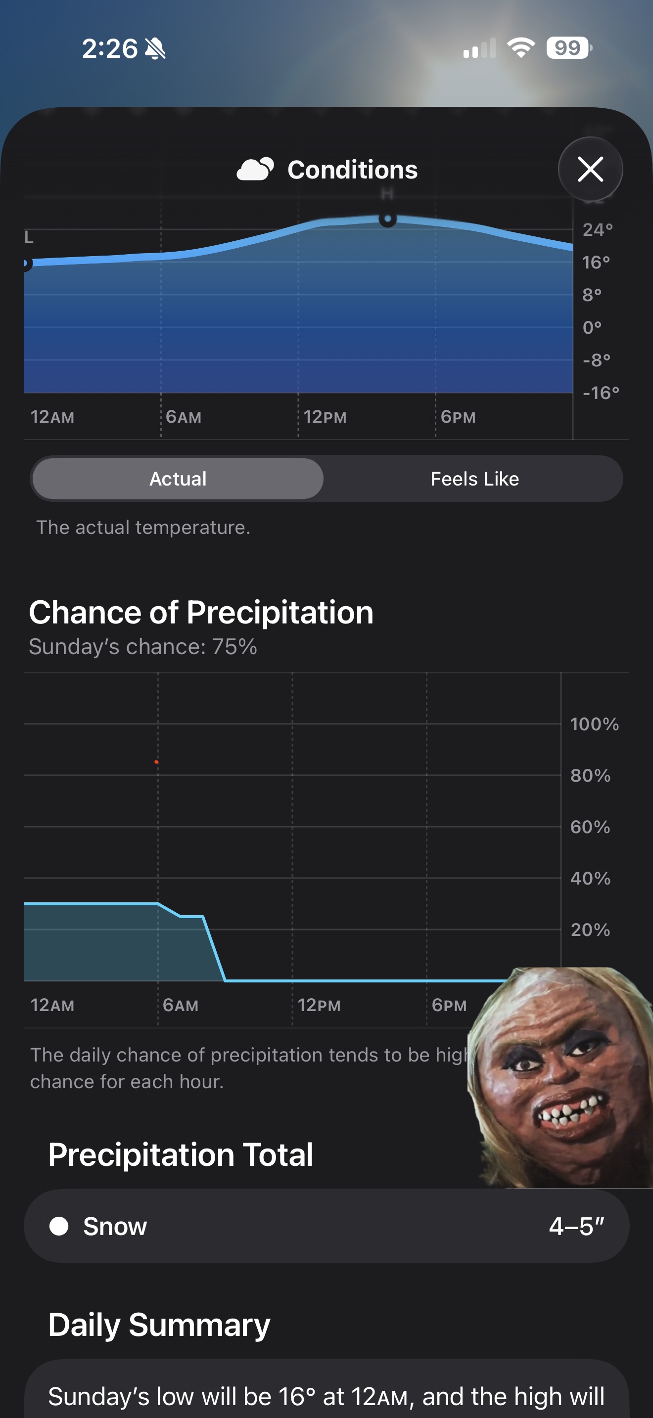
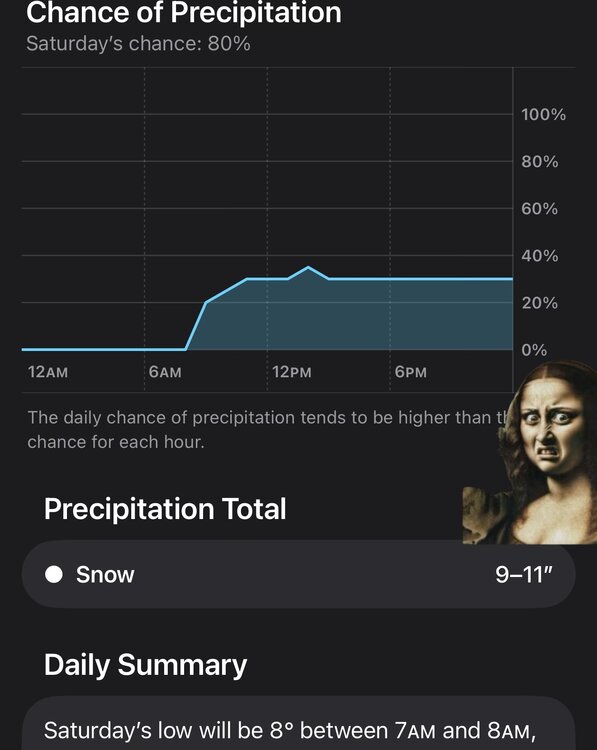
This is getting out of hand. I pulled this from the native Apple Wx App. Note the snowfall amounts. Like come on now.

-

The “I bring the mojo” Jan 30-Feb 1 potential winter storm
wncsnow replied to lilj4425's topic in Southeastern States
Very well it was north of every model and closest to verification -
Wisp reporting 19" storm total - with another 2-4" of upslope today.
-
 are the other obs recent too? seems a bit out of place, and is it a spotter or official?
 -
The place we live in has gravel roads and they don't plow because it wrecks the gravel base. Spent the last hour driving my truck around packing in tracks. What a blast but it sure isn't snow lol. It was more like compressing hot asphalt. My tires barely left tread marks. It's hilly here so I have a hunch that no 4wd vehicle (without chains) will be able to pull the hills tomorrow AM when everything sets like concrete. Our land is gravel road access too and our gravel drive is a solid hill. Didn't bother messing with that today but should be fun/interesting tomorrow
-

Possible coastal storm centered on Feb 1 2026.
cleetussnow replied to Typhoon Tip's topic in New England
uh no this is not a SWFE More like a triple phaser?


.thumb.jpeg.f5c6ba9d911ec96b3b124f8606aee58e.jpeg)