All Activity
- Past hour
-
I prefer to remain non-confrontational... heh Having said that, he did say, "March finished +4 " I'm not sure where he was looking - I could see that happening though because a theme I've been playing with in my posts is that we get modestly warmer than normal monthly means out of colder looking synoptic constructs. It's one of those obfuscating charms of CC. It makes sense. If the d(T) is always positive, that means we're on a slope, so the same synoptic conditions should register at least decimals warmer than the last incarnation. It may be a straw man argument at this point, but I do sense that people rely a bit too much on the old adage, "CC doesn't make it warm today" .... noooo, buuuut, it does mean one should expect it to be warmer than the last time. It's just another subversion thing people that know better than to deny, but can't stand the truth.
-
The season is still going strong for me. Lovely day skiing Saturday, partly sunny 60s. Went to the Red Sox game in the afternoon. I should have stayed and skied longer! Miserable weather and team! .
-
Records: Highs: EWR: 83 (2023) NYC: 80 (2023) LGA: 80 (1947) JFK: 74 (2023) Lows: EWR: 17 (1982) Blizzard NYC: 21 (1982) LGA: 22 (1982) JFK: 20 (1982) Historical: 1898: Nor'easter: Hampton Roads recorded 75 mph sustained wind from the north and Cape Henry at 105 mph. Tides at Norfolk reached 8.37 feet above Mean Low Water, which is over 4 feet above flood stage level. The Norfolk Landmark, April 7, 1889:"...The storm was equal of the famous one of August 18, 1879. Water Street from end to end was a river of raging water; both ends of Main Street were covered with water, West Main Street as high as Jackson. Jackson Street was flooded clean up to Main Street. The water was a foot at the station-house door, and all the lower Washington area, was far under water." (Ref. Virginia Weather History) 1927: On this date through the 7th, in Oklahoma, heavy rain added to already high stream flows, producing a devastating flood along the Arkansas River, below the mouth of the Neosho River. The flooding lasted through the 19th, inundating 165,000 acres of land, with losses totaling $4 million (1927) dollars. (Ref. Wilson Wx. History) 1929: EARLY HEAT WAVE- The maximum temperature for the date is 92°F. in Washington, DC. (Ref. Washington Weather Records - KDCA) 1936 - A tornado outbreak in the Deep South resulted in a total of 446 deaths and eighteen million dollars damage. It was a "Tale of Two Cities". During the evening of the 5th a tornado hit Tupelo MS killing 216 persons, injuring 700 others, and causing three million dollars damage. The next morning the paths of two tornadoes met about 8:30 AM and cut a swath four blocks wide through Gainesville GA killing 203 persons, injuring 934, and causing thirteen million dollars damage. Eight to ten feet of debris filled the streets following the storm. At least 70 persons died in the Cooper Pants Factory, the greatest tornado toll of record for a single building. (David Ludlum) (The Weather Channel) 1942: High pressure off the southeast coast provided an unseasonably warm south to southwesterly flow across the Mid-Atlantic into the southeast. Many high temperature records were set including Richmond, VA: 92°, Washington, D.C.: 92°, Elizabeth City, NC: 91°, Philadelphia, PA: 87°, Reading, PA: 86°, Trenton, NJ: 86° and Mt. Pocono, PA: 80°. (Ref. Wilson Wx. History) 1973: On this date through the 8th, a major spring snowstorm dumped 11.6 inches of snow across Denver, CO. Most of the heavy wet snow of 10.1 inches fell on the 7th when temperatures remained in the 20s. The low temperature of 5° on the 8th was a new record low for the date and the lowest for so late in the season. (Ref. Wilson Wx. History) 1976: The Black Hills of South Dakota experienced the fury of the thunderstorm and a bit of an unusual snow. During the afternoon hail piled up to 3" deep in Hot Springs, SD while elevations above 5,000 feet in the Hills received over an inch of snow from the storm. (Ref. Wilson Wx. History) 1982: A huge blizzard on the 6th and 7th dumped one to two feet of snow across parts of Pennsylvania, New York and New England. Many areas reported thunder and lightning with heavy snow. Winds gusted in some places to 80 mph. For many places, it was their worst April snowstorm on record. The Yankees home opener with the Texas Rangers was canceled. The New York Mets could not make their opening game in Philadelphia because the bus was snowed in. Behind the storm in the upper Midwest, unseasonably cold temperatures and snow prevailed. The low temperature was 5° at Rochester, MN and 7° at LaCrosse, WI (tied on 4/6/1946) are the coldest April readings for both locations. Other record low April temperatures set this day: Preston, MN: -8°, Theilman, MN: 0°, Caledonia, MN: 2°), Fayette, IA: -2°, Cresco, IA: -1°, Charles City, IA: 3°, Decorah, IA: 5°, Osage, IA: 6°, Guttenberg, IA: 7°, Viroqua, WI: -8°, Blair, WI: -4°, Sparta, WI: -1°, Richland Center, WI: 0°, Genoa, WI: 6°, Lancaster, WI: 6°, Trempealeau, WI: 8°. Snowfall totals included: Prairie du Chien, WI: 8 inches, Fayette, IA: 6 inches, and Richland Center, WI 6 inches. (Ref. Wilson Wx. History) Ref. (NWS Ranking for Storms between 1956 and 2011) This is the 34th Worst Snowstorm 1983 - The temperature at Denver, CO, dipped to a record cold seven degrees above zero. (The Weather Channel) 1987 - Rain and melting snow caused flooding from New England to Ohio. Flooding in the Merrimack Valley of Massacusetts was the worst in fifty years, causing forty-two million dollars damage. (The National Weather Summary) (Storm Data) 1988 - A powerful storm produced wind gusts to 75 mph around Chicago, IL, and wind gusts to 92 mph at Goshen IN. The high winds created twenty-five foot waves on Lake Michigan. (Storm Data) (The National Weather Summary) 1989 - Unseasonably hot weather prevailed in California. Afternoon highs of 91 degrees in Downtown San Francisco, 93 degrees at San Jose, 98 degrees at San Diego, 103 degrees at Santa Maria, 104 degrees at Riverside, and 106 degrees in Downtown Los Angeles established records for the month of April. (The National Weather Summary) 1990 - Snow developed in the northeastern U.S. for the second time in the month. In Virginia, a heavy wet snow blanketed northern and central sections of the Shenandoah Valley, and eastern foothills, with up to 12 inches reported around Harrisonburg. Heavy snow also blanketed the high elevations of West Virginia, with 10 inches reported at Snowshoe. An inch of snow at Syracuse NY raised their total for the winter season to a record-tying 161.3 inches. (The National Weather Summary) (Storm Data) 1997: A three day blizzard in parts of central and eastern Montana ended on this date. Melville, MT picked up 18 inches of snow while Ashland, MT reported 15 inches. Drifts up to six feet were reported in Powder River County. 50,000 head of cattle and sheep were lost in southeastern Montana. (Ref. Wilson Wx. History) 2005 - Thunderstorms erupted and produced severe weather including 32 reports of tornadoes, most of which touched down in Mississippi and Louisiana. Between 20 and 25 homes were destroyed and 7 people were injured. Mississippi governor Haley Barbour declared a state of emergency (CNN). 2007: Cleveland, Ohio on the 6th to the 9th: The opening-season series between the Indians and Minnesota Twins is wiped out by a snowstorm and a cold snap. The Indians lead 4-0 when their home opener Friday (the 6th) was called off by umpires because of heavy snow. The grounds crew who tried to make the field playable with backpack blowers and brooms, spent more time on the field than the players during nearly three hours of stoppages. About a foot of snow remained on the field Monday afternoon (the 9th). (Ref. WxDoctor) 2010: Thunderstorm winds to 105 mph caused $10 million damage to the Grinnell, Iowa area. Six members of the Grinnell College track team were caught in the open and plummeted by hail to 1.5 inches in diameter and needed medical treatment. (Ref. Weather Guide Calendar with Phenomenal Weather Events 2012 Accord Pub. 2011, USA)
-
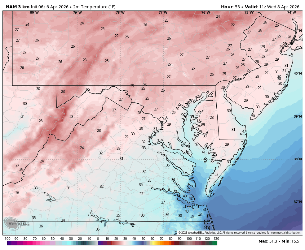
Widespread freeze incoming for Wed. Am. WB 6Z 3K NAM

-
Beautiful Morning. Couldn't ask for better.
-
Yeah I was confused. This past March was actually colder. Not sure why he’s hell bent on making it seem like it was better, but April has a chance to be mild from what I see.
-
48 / 27 36 hour chillier stretch before an overall warmer than normal period with sprinklings of strong warmth early next week 13-15th. Drier week ahead with <0.50 over the next week.
-
huh... Ironic. The PV's showing signs of finally shifting away from 90/60 in these ensemble means toward mid month.
-
i dunno man, this March (37.0) was much cooler than last March (38.1). will be interesting to see the temp comparison after April
-
To jbenedet's point ... the operational runs are coherently weaving a warmer tapestry out there beyond this thing. Thursday through the weekend... The cold air intrusion now thru Wednesday alleviates during Thursday. It's not going to wildly surge the other way, but 540 to 552dm hydrostats in a return WSW continental flow and ample post equinoxian sun ... will likely present modestly above normal. The next cold front after doesn't carry nearly the same bite/post cold weight as depicted.
-
Wake county got screwed, sounds familiar. Eastern NC especially east of 95 got a widespread 1-2” rain and we couldn’t even get enough to wet the dirt
-
I makes me wonder what the world is capable of delivering around here, if/when the pattern foot actually did flip warm.
-
Yeah, I'm just open speculating/making conjecture on the BD frequency aspect in that morning joe From a "personal" anecdotal perspective, I've observed more than is normal even for here? Relative to date that is. If we were to do the last 10 days the rest of the way, we'll have clocked 3 to 4 times the normal seasonal loading by June 1. That's a lot ha! I don't disagree about the March numbers though. I snuck in a few edits into that post ... one of which was the jest that (CC + the increasing solar)/2 is skewing matters. These latter factors are creating tension in perspectives over the years, because the patterns are cold typology but we still get nuisance warm anomalies. interesting.
-
Despite a little chill in the air thru Wednesday, this is setting up to be a stellar week. Perhaps the next 7-10 days.
-

Central PA Spring 2026 Discussion/Obs Thread
Mount Joy Snowman replied to Voyager's topic in Upstate New York/Pennsylvania
Low of 38 with .42" of rain. Mondays, they are the worst. - Today
-
These next three days are the last of the chilly. After Wednesday, it looks mild to very warm at times and above normal
-
I dunno Tip. These doors happen with such regularity because without them our spring climo in the seacoast region would be like Philly otherwise….it really is just that. We have a three day BN interlude and then it’s back to solidly AN. March finished +4 If April matches—which looks doable given the persistence and latest ensemble guidance— this early spring will much better than last, or any of recent memory…
-

2026-2027 El Nino
40/70 Benchmark replied to Stormchaserchuck1's topic in Weather Forecasting and Discussion
I would like to see the ONI coupled at around 1.7 or lower, and I bet we would see a better winter independent of the Modoki index. -
Yeah just a dusting here too, but back to white. A reminder that I guess it’s not as far away as it feels.
-
We've had decent springs once in a while over the decades but those are more the exception to the rule. As climate and data empirically show, we more typically suffer these ~ 6-week purgatories between the end of March and early May ... give or take. Some are cold and "that one last chance to snow", along with a bit of questionable perspectives on reality hold outs ... heh, notwithstanding. For those that long for warmth and covet those visions, this year seems particularly annoying so far. What is happening(ed) is a very persistent PV, wobbling around 80..90W/60N up in Canada. So long as that is the case there is going to be an anomalous polar jet around the southern periphery. Having jet streams fixated across S and SE Canada in the means are going to create problems for us to ever warm up prior to June 15 really ... for a much longer discussion of reasons. Just in the past 6 days ...we've observed like 3 different species of BD fronts. N doors, E doors, quasi BDs whose identity lost in a normal door... We may be carrying a positive anomaly in BD even for our spring lorn region, but it's because we have a multi-month ridiculously resonant pattern more typically observed in an average January. If you took the typical January pattern foot, and mapped (CC+ SOLAR seasonal change)/2 over top, you get what we are getting.
-
2026-2027 El Nino
40/70 Benchmark replied to Stormchaserchuck1's topic in Weather Forecasting and Discussion
It makes perfect sense to me that if the essence of El Nino is anonymously warm water modulating the Hadley Cell via enhanced convective activity, then warming up the water to the west of ENSO is going to reduce it's ability to do so because the MC is going to rob the ENSO region of some of that convection....ie it's a competing force. -
I keep having to remind myself it's just the first week of April... It's just a slog, this time of year.
-
Whopping 0.02" and not a drop in the forecast. Sprinkler's a comin'.
-
2026-2027 El Nino
40/70 Benchmark replied to Stormchaserchuck1's topic in Weather Forecasting and Discussion
I am willing to bet that if we were to ditch the gap between the RONI and ONI, or even have the ONI lag the RONI, we would get lower heights in the southeast....my guess is in order achieve that we are going continue to have to see that western Pac warmth spread eastward, which would help to reduce that persistent, residual cool ENSO residue. Again, don't mistake me overvaluing the RONI in-and-of-itself....it's what it represents, which is the surplus of western Pacific warmth relative to the eastern Pacific reducing the ability of +ENSO to couple with the atmosphere, and thus modulate the northern Pacific in the manner that we would like. -
Had a low of 35 degrees this morning.