All Activity
- Past hour
-
So frustrating it trended better in several ways but worse in the one that might matter most.
-
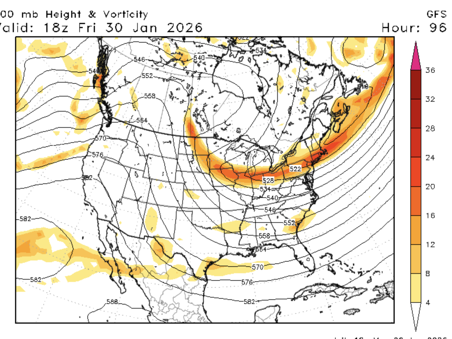
GFS not even closing off a low at H5 anymore....well so far
-
Trying to close off at 117
-

Possible coastal storm centered on Feb 1 2026.
40/70 Benchmark replied to Typhoon Tip's topic in New England
-
Surprised at how good the roads in Pasadena are. Side streets are snow packed but very manageable and main roads are blacktop and dried out.
-
I wouldn't say every big storm has trended that way.
-
My sister lived there for 25 years. It’s a beach town. So you’re analysis is accurate.
-
Yea I switch from h5 to surface and I don’t see what I expect
-
Not splitting the 500mb energy as fast as the cmc and euro.
-
They do have free rides on the MTA. School buses are for special needs students only.
-
The ridge is slightly better oriented imo. It’s getting closer to what we want to see
-

Possible coastal storm centered on Feb 1 2026.
RUNNAWAYICEBERG replied to Typhoon Tip's topic in New England
Oh boy. Gfs better at h5 too. Just keep it real and close for another 2 days… -
I have a nice dusting now at my house. Amazing how a few degrees of change in direction in the atmosphere can just flood one valley or another with NWF.
-
 Here comes the widespread 20 inches for southern New England
 -
Only for special needs students
-
Seems better on paper, but not seeing downstream results that we need so far
-

Extreme Cold, Snow & Sleet: SECS 1/24 - 1/26
NorthShoreWx replied to TriPol's topic in New York City Metro
I'm in the 'wipe the board on phase changes' camp. Here is an example scenario illustrating some of the possible outcomes of only wiping once per 24 hours and not at phase changes. Some of it isn't that far off from the reality of yesterday's event: - location 1 gets 8" of low water content fluffy snow and the storm ends. - location 2 gets the same 8" of low water content fluffy snow which then switches to sleet and 2" of sleet accumulate on top of it. By the end of the storm later that day the snow depth has compressed to 8" (or less). - location 3 gets 2" of sleet first, followed by the same 8" of fluffy snow. - locations 1 and 2 report snowfall as the maximum depth of 8" - location 3 reports a maximum depth of 10" as the daily snowfall. Location 3 no doubt had the deepest snow depth. Location 2 and 3 had the exact same amount of snow and sleet, but a different entry in the climate record. Location 2 had more than twice as much frozen precipitation as location 1, but the only way to tell that is from the SWE. They each report the same amount of snow and sleet. On thing that stands out as being lost in these examples is the standard that snowfall includes snow and sleet. Does it really include sleet for location 2? -
Through 90 it’s better. Might not do it but it’s heading the right way
-
Taller pna ridge, heights off the EC a bit heigher
-

The “I bring the mojo” Jan 30-Feb 1 potential winter storm
Snowncanes replied to lilj4425's topic in Southeastern States
True, I guess I hadn’t seen how bad the 12z run was haha. Definitely trended better for us -
 Here comes the vortmax stuff blossoming right on queue (guidance was really hitting after 21z). Should be pretty decent for a few hours
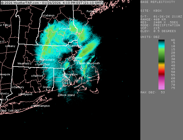
-

-
the downtown core doesn't rep the whole city either...its a bowl. Low in the center with elevation as you go NW or SE. And DC has a helluva lot more green than some other cities.
-
Yeah, H5 is noticeably better, still can't say what this means down the line tho
-
Winter 2025-2026 Offers Return to Normalcy
40/70 Benchmark replied to 40/70 Benchmark's topic in New England
Major Follow-Up Potential Looms Next Weekend Active Pattern Prime For East Coast Storms Warrants Heightened Vigilance Despite the final flakes having yet to flutter down from the ongoing storm, Mother Nature is already seemingly taking aim on an encore performance next weekend. The approximate one week lead time of this system renders tropical forcing an invaluable tool to anticipate any future trends or morphologies that are likely to take place throughout the balance of the week. Tropical Forcing Offers Modest Constructive Interference With One Caveat The anticipated tropical forcing regime is ostensibly constructively interfering with, or supporting, the pattern modeled for next weekend on the European ensemble mean, which happens to be very favorable for major east coast cyclogenesis. Note that the European guidance also forecasts the MJO to translate through phase 8, albeit it at a rapid pace, this weekend, which strongly supports the modeled pattern that is so conducive to east coast cyclogensis. GFS-based guidance concurs. This major Miller A scenario also has cross-ensemble support both the GFS and GEM ensemble mean camps. Thus this scenario could conceivably be considered a rather high probability outcome. However, although support for a major east coast storm is undeniably strong, that may not be the case for this particular evolution when considering the recent past. Using History As A Guide The protracted winter storm that is still having some residual impacts across the area was once modeled as major snowstorm throughout the middle Atlantic region, and while that region did in fact receive significant snows, the heaviest snows ultimately shifted north. The resemblance between the modeled pattern for next weekend, and the original portrayal of for this past weekend is quite striking overall. However, the trend that ensued throughout the week was for the primary low to remain dominant longer, rendering this more of a Miller B type of evolution. A reoccurrence of this type of morphology with respect to the characterization of cyclogenesis would not at all be unexpected should the MJO never really materialize in phase 8, and there is reason to believe that that may very well be the case. Potential Implications of "Phantom-Phase 8" Last fall, Eastern Mass Weather Winter Outlook paid homage to a prevalent trend over the past decade for guidance to overemphasize the passage of the MJO through phase 8 due to the persistent warmth throughout the western Pacific. Note the continued presence of this warm pool this season. Interestingly enough, despite the below average season to date in terms of temperature, the MJO has spent a total of just nine days in phase 8 thus far this season. Guidance has continued to overestimate the both the residence time and amplification of the MJO in this phase and there are indications that continues to be the case. The implication of this could potentially be a trend towards more of a Miller B type of evolution throughout the week, not unlike what occurred last week, which is something to watch. This is reflected in the CPC analog guidance. The bottom line is that a major form is favored near the east coast next weekend, details to be determined.