All Activity
- Past hour
-
verifying
-
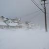
Heaviest snow of the storm! Gotta be at 18” now
-

"Don’t do it" 2026 Blizzard obs, updates and pictures.
dendrite replied to Ginx snewx's topic in New England
That deformation band may try to get up here briefly. But with the N flow you’re going to need it to get a little north of you on radar and that may be a tough task. -

"Don’t do it" 2026 Blizzard obs, updates and pictures.
ROOSTA replied to Ginx snewx's topic in New England
Should be a snowdrift scale for Extreme Winter Events...LOL -
Snowman focusing on the least snowy models is par for the course.
-

Central PA Winter 25/26 Discussion and Obs
Itstrainingtime replied to MAG5035's topic in Upstate New York/Pennsylvania
Sounds like we ended up at about the same amount. Looked like it on the way to work, too. Down here at Turkey Hill there was/is well north of 4" it appears. -
2006 and 2016 were ratters except for two one hit wonders; i think 2016 delivered our yearly average in one storm. so you can get big ones even in warm years. i never thought much of 2015; it was all piddly events in succession. 2014 is my all time favorite though; lots of 8-12 events. better on the back, enough to get cancelations, and not so crippling. snowing again here and still nasty out; don't like to clean up while its still coming down, and the rest of the house is still sleeping, so no help. snow too deep for the dogs now, and one idiot won't come in if i let him out. as i've noted, my neighbors will call animal control if they see a dog outside. its ok for them to stink up the neighborhood with pot though...can't even sit in the garden in summer its so bad, and one dog ate some of their stash somehow and i had to rush her to the vet....but i digress.
-

"Don’t do it" 2026 Blizzard obs, updates and pictures.
Lava Rock replied to Ginx snewx's topic in New England
GYX, knocked us down from 4-8" to 3-5". Be surprised we get 3". That's ok looks like 3-5" weds night. -
I don't see anyway EWR doesnt get past 2 feet clean based on their 18-ish report around 630-7 - maybe even 26-ish.
-

Feb 22nd/23rd "There's no way..." Obs Thread
Solution Man replied to Maestrobjwa's topic in Mid Atlantic
Congratulations Cape, beautiful -

Feb 22nd/23rd "There's no way..." Obs Thread
DDweatherman replied to Maestrobjwa's topic in Mid Atlantic
Those balls are old Mitch, that could be why. -

"Don’t do it" 2026 Blizzard obs, updates and pictures.
Chrisrotary12 replied to Ginx snewx's topic in New England
Oh I have many snow storms that rival or exceed 78 in terms of snowfall. But the closest I’ve come from a snow and wind perspective is January 2005. We’ll never see another 78 because we won’t have the mass societal impacts because 78 happened. -
Fable of the Scorpion and the Frog. .
-

"Don’t do it" 2026 Blizzard obs, updates and pictures.
jbenedet replied to Ginx snewx's topic in New England
The mid level track appears further north than guidance had it, seeing the slot flirt with the islands. -
Central PA Winter 25/26 Discussion and Obs
Itstrainingtime replied to MAG5035's topic in Upstate New York/Pennsylvania
3 separate measurements this morning at 5am yielded a total snowfall in Maytown of 3.6". I received nearly 2" of snow after 11pm. Thrilled to nail my forecast from Thursday of 3-6" and glad that I never wavered from it. Wasn't sure last night I would make the low end. -

"Don’t do it" 2026 Blizzard obs, updates and pictures.
JJBASHB replied to Ginx snewx's topic in New England
This has to be close to 1/4mi vis now. Snow has that wavy look in the pulses of wind. Most fun yet. -

"Don’t do it" 2026 Blizzard obs, updates and pictures.
NeonPeon replied to Ginx snewx's topic in New England
Hrm. I saw multiple cars barely distinguishable from the 6 foot drifts that enveloped them. It's a give and take. -

"Don’t do it" 2026 Blizzard obs, updates and pictures.
Brian5671 replied to Ginx snewx's topic in New England
No idea what I have given the wind but certainly 12+ -
Looks like I picked the wrong week to stop sniffing glue
-
Rjay, that Rutgers conditions map set, that I post sometimes, used to give you the PAST 12 hours of radar. One could wake up and look back at what happened overnight. It was great, but hasn't worked in a couple years.
-

Pittsburgh/Western PA WINTER ‘25/‘26
MikeB_01 replied to Burghblizz's topic in Upstate New York/Pennsylvania
nice burst in the south hills right now -
Hoping to fill in here
-

Central PA Winter 25/26 Discussion and Obs
MAG5035 replied to MAG5035's topic in Upstate New York/Pennsylvania
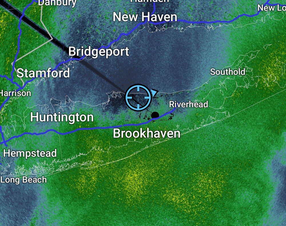
29ºF and snowing decently at the moment with the band that just dropped in from the north. This stuff looks like it has some enhancement from Ontario with the due northerly fetch so maybe it’ll actually do something this morning. For now 1.2” fell overnight to bring storm total to 2.5”. Been pretty breezy with a high gust overnight of 35.6 mph on the station. Gonna have a look at totals vs the map I put out when this thing completely wraps up. Did not expect the York/Lancaster realm to do as bad as it did. I knew it was boom or bust potential there but I expected at least warning criteria to be met there fairly easily. The temps were an absolute killer yesterday with the lighter precip phase of the storm. IVT set up further east as noted and I think the storm really exploded just a hair late. It is living up to its billing in NJ/NYC/LI and beyond. There’s already scattered 20”+ reports in NJ and LI, as well as a 71mph gust on the tip of LI. Official obs in Central Park, La Guardia, and JFK all reported 15” or so around 7am with a good bit of snow to go. -

"Don’t do it" 2026 Blizzard obs, updates and pictures.
Hoth replied to Ginx snewx's topic in New England
No idea how much I've got. Jammed my yardstick in various spots across the driveway and got between 15-19" at 7 a.m. -
It happens every now and then, especially with windy storms or charged up storms. I’m also on top of a hill, so it grabs the wind. .