All Activity
- Past hour
-
I wouldn’t mind a nice 36” again especially if it falls during the day! Thundersnow was the best that night .
-
It’s coming
-

Winter 2025-2026 Offers Return to Normalcy
40/70 Benchmark replied to 40/70 Benchmark's topic in New England
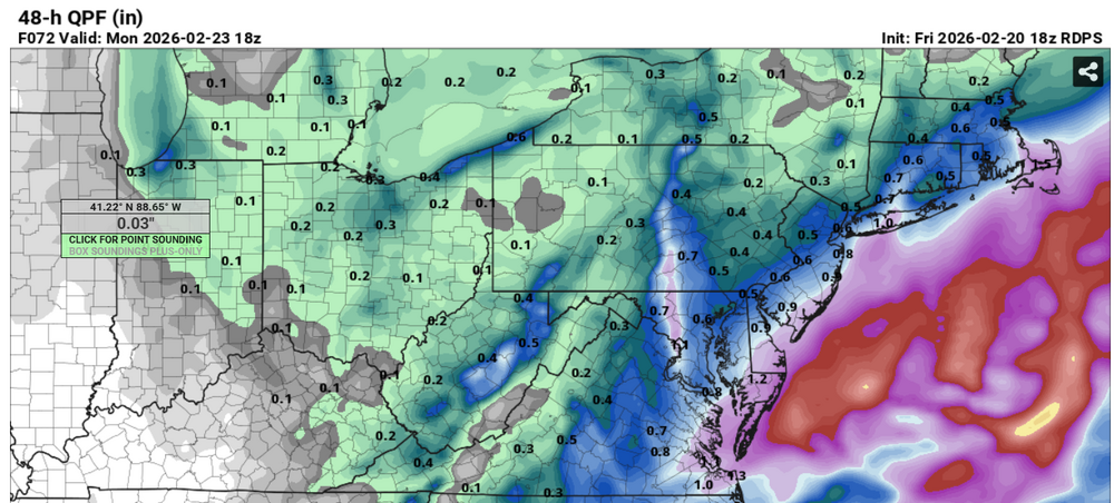
Severe Winter Storm Imminent Sunday Evening Through Monday Widespread Closures Likely Monday-Tuesday Eastern Mass Weather Mea Culpa Concerning Impending Blizzard of 2026 Eastern Mass Weather confidently opined as recently as Tuesday that there would be no major winter storm impacting southern New England on Sunday into Monday. It is now patently obvious that this is the exact opposite of what is actually going to happen due to some crucial morphologies that have taken place. Synoptic Overview The amplified Pacific trough responsible for the significant thaw this week is in the process of breaking down as this passage is written, but not before it delivers a couple of parting gifts that will ultimately replenish all of the snow that has melted, and then some. There are two final parcels of energy that have ejected into the plains from this dying trough during the day on Friday. The amplification of the nascent ridge in place of the trough over the inter mountain west on Saturday will ensure that these pockets of energy encounter a relaxed gradient on the east coast over the weekend, as heights over the southeast fall in response to the development of the aforementioned ridge out west. This ensures that the energy is not sheared apart in much by the compressed flow between the polar vortex/block dyad to the north, and the southeast ridge to the south, in much same manner the previous two systems. It is because of this relaxed flow that the energy with these two disturbances can coalesce and phase beneath the block upon reaching the east coast by Sunday night. This is where it becomes apparent that the North American landscape has changed since this major storm was expected to remain south of the forecast area. Not only has the PNA ridge over the western CONUS trended significantly westward into a position ideal to foster the development of major east coast winter storms, but the system currently affecting the region also departs into the Canadien Maritimes at a slightly faster pace, which allows confluence to lift north. This is crucial because it the position of the PNA ridge and the confluence north of Maine that were cited as the reasons why this storm would not be unable to travel up the coast. Below is a juxtaposition of guidance from Tuesday morning (right) and Friday morning (left) to better illustrate these changes. The differences are apparent, and the discrepancy concerning the placement of the Western ridge is even more apparent when comparing guidance this morning (left) to last Sunday (right). It is these changes that leaves the forecast area, along with much of the east coast, poised to experience the full wreath of the impending blizzard of 2026. Expected Blizzard Evolution Snowfall should overspread the region from south-southwest to north-northeast on Sunday afternoon. Snowfall will rapidly become heavy Sunday night, with banding increasing at the apex of the storm from around midnight through Monday morning. Note two distinct bands, one over southeastern Mass and one from southeastern New Hampshire into the east slopes of the Monadnocks and Worcester hills. However, it is important to note that these are estimates and the precise location of these bands is exceptionally difficult to diagnose. The very heaviest amounts of snowfall are likely to be within these bands, as well as on the east slopes of the Worcester hills, where a deep layer easterly fetch will induce upslope enhancement. While 850mb flow off of the Atlantic will ensure that the variation in snowfall between bands will not be as extreme as is often the case in systems of this magnitude, amounts are likely to be somewhat lower between these bands due to some extended residence time. Some mixing is likely on Cape Cod during the height of the storm on Monday morning, as the track of the low comes close enough to entrain some milder ocean air on hurricane force wind gusts that will induce moderate coastal flooding and beach erosion. Finally, precipitation begins to taper off later in the afternoon and into the evening, ending well before midnight Monday night. First Call: -

“Cory’s in NYC! Let’s HECS!” Feb. 22-24 Disco
CT Valley Snowman replied to TheSnowman's topic in New England
Reggie improved a notch but still a bit flaccid compared to some of the more dynamic solutions. -
Rgem is much better
.thumb.png.179ef47aa45e49eb946ea87a0a156d30.png)
-

“Cory’s in NYC! Let’s HECS!” Feb. 22-24 Disco
Sey-Mour Snow replied to TheSnowman's topic in New England
Let’s get you to dryslot -
Pretty sweet when this is the lowest output
-

“Cory’s in NYC! Let’s HECS!” Feb. 22-24 Disco
HoarfrostHubb replied to TheSnowman's topic in New England
Someone is gonna get croaked. Your map is as good as any. Lots of reasoning in there -

Southern MD / Lower Eastern Shore weather discussion
SnowtoRain replied to PrinceFrederickWx's topic in Mid Atlantic
Icon similar as well -
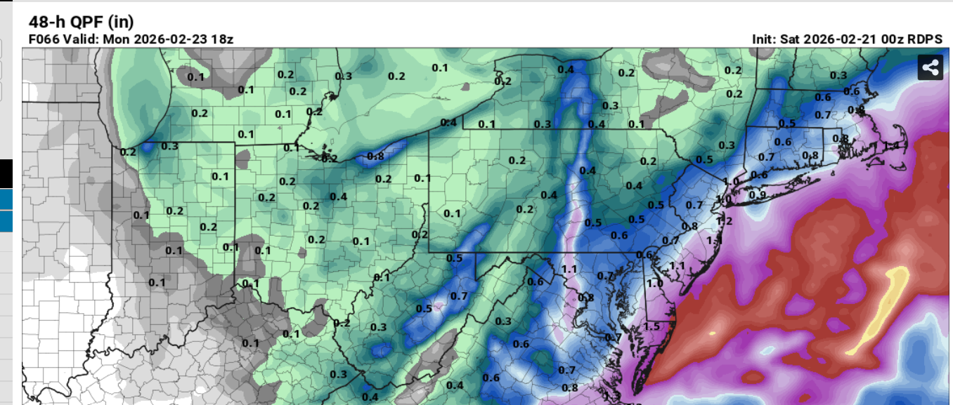
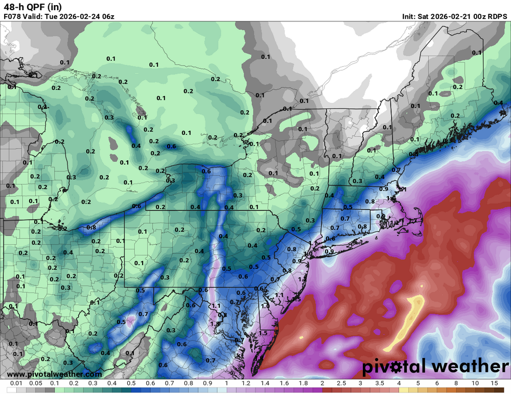
2/21 00z RRFS (planned to replace HRR / Fv3 at some point) Total QPF 2/22 - 2/23-24 Snow 10:1
-

The February 22-23 Late Season Miracle: JV Disco/Banter Thread
Nomz replied to bncho's topic in Mid Atlantic
-

“Cory’s in NYC! Let’s HECS!” Feb. 22-24 Disco
Ginx snewx replied to TheSnowman's topic in New England
Is RUNNAWAYICEBERG still at Waffle House? -
Still can’t quite get the rgem/cmc to come all in, it keeps getting a little better each run though. Kind of annoying, but no fret
-
Hey welcome back man. Everyone thought something happened to you . Glad to see you’re good!!
-
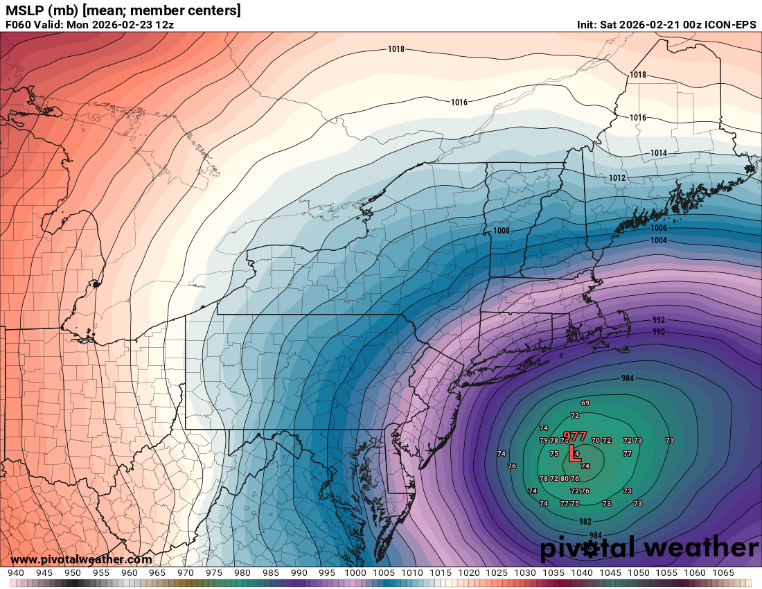
Icon eps west

-
Where is bob chill????
-
HECS
-

“Cory’s in NYC! Let’s HECS!” Feb. 22-24 Disco
ScituateMA replied to TheSnowman's topic in New England
Need sustained winds of over 35mph for 3 hours with heavy and blowing snow. So gusts dont always cut it. -
That could be 4 inches per hour with thunder. Crazy!
-
Eaglesfan guy would heavy argue against that lol
-
Haha. Thanks. The gfs with its best victory since 2010 If things do not change this storm has the potential to put the winter of 2025-2026 in a category with some Of the best
-
I was comparing his 10:1 map to the Kuchera map and responding to his statement to cut 10:1 by 25-33% to get Kuchera.
-

The February 22-23 Late Season Miracle: JV Disco/Banter Thread
EHoffman replied to bncho's topic in Mid Atlantic
Welcome to DC, better get used to it -
RGEM 00z Vs. RGEM 18z Further west on RGEM vs 18z but not as far west as NAM and ICON
-
That's what @WxMan1just posted- snow depth. Real numbers


.png.5eda13644691fb32a5b14a91f704cbe3.png)