All Activity
- Past hour
-
There is a winter storm warning and winter weather advisory in the Rockies. Much of the country has heat watches/advisories, the pink is a red flag warning, the other pink is a, severe thunderstorm watch, and the blue is a freeze warning, the other blue is a frost advisory.
-
I guess we’ll see
-
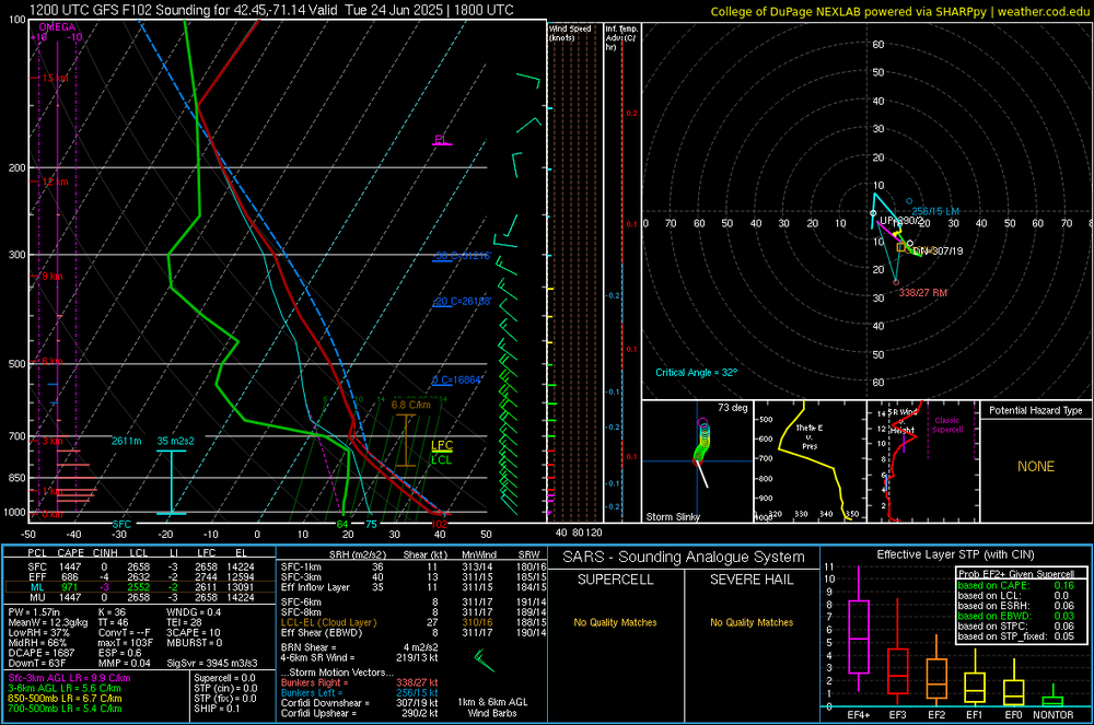
GFS mixes up to almost H7 with only 15-20kt wind up to 600mb. Idk…seems a little overdone as usual to me.
-
First time here ,only up here because my wife is competing in equestrian. But it really is a nice place! Plenty of restaurants downtown but also lots of hiking, lakes & nature close by. Enjoying it a little more than Lake George and Lake Placid honestly but also not as far of a trip.
-
What does hazardous chemicals have to do with elevated bacteria levels, unless the "hazardous" chemicals are a food source for the bacteria, but I would be surprised if that growth would happen naturally. More likely a washout from a wastewater treatment plant from a sudden storm or just from leaching out of local septic tanks and leach fields.
-
Sea breeze for Monday was sniffed out over the past couple of days. The hottest day will be Tuesday, looks like it will start off with offshore flow then a sea breeze develops, for coastal locations at least. Still will be brutal even with the sea breeze. I can see this being similar to 7/22/2011 where ISP hit 100 before the sea breeze, but still had temps in the mid to upper 90's after the sea breeze. I don't think dew points will be as high as they were in 2011. Also possible that we fall just short of 100 ISP on 7/22/2011:
-
I would never take a car thermometer reading at face value (in the old days we used to have the old bank clock joke with @A-L-E-K). I was just pointing out that the varying temperatures in that area are obvious.
-
Shoreline Scorcher
-
Exactly, I got the mowing & yard work done this morning. It was nice to have some sun with manageable dew points. My Family vacation to Cape May begins on Sunday. Hopefully it’s a few degrees cooler on the immediate coast with a sea breeze!
-
I think we're all getting thrashed with the heat on Tuesday.
-
I was using the 30 year avg. Which is June 10th. The POR avg is June 18th.
-
Not at Detroit, it isn't. The long-term mean is June 18th. Three years saw 0 90+ days (1882, 1907 & 1915), and therefore aren't included in the analysis.
-
Ready to roast.
-
Funny you mention it, I was looking at bringing the family up to Duluth this weekend to escape the heat but it’s Grandma’s Marathon weekend so your assertion that half the state will be up there is probably accurate. Point forecast bumped up to 98 at MSP. Outside chance we break triple digits. The splash pad will be out in our yard this weekend and I’ll be trying to convince the kids to play in the basement.
-
Good. I don’t need 100 degree heat. Let the ocean cool us off while inland roasts
-
Overview of Wednesday's event across IWX: A line of strong to severe storms moved across the area in the afternoon and evening of Wednesday, June 18th, 2025. Overall, damage was generally confined to numerous instances of tree damage, scattered reports of power lines down, and some associated roof/siding damage to buildings/homes. Wind gusts were estimated to be between 50-60 mph. There were a few reports of quarter to golf ball size hail in northeast Indiana. The most extensive wind damage occurred in Van Wert County, OH; wind speeds of up to 70 mph downed an estimated 100 trees and caused minor damage to homes and buildings in the city of Van Wert. Van Wert County EMA director Rick McCoy said that this was the worst wind damage he had seen since the 2012 derecho. There were no injuries or fatalities. https://www.weather.gov/iwx/06182025_SevereWeather?fbclid=IwY2xjawLCqTRleHRuA2FlbQIxMABicmlkETBydHc3SEtscWREOFdOT1owAR7GZzaMMAguYLVWOFAczQU94f_75FcJfH_dNy9cL1It5yYarhFeMlsBMcNk1A_aem_ghpY_Dnre1a_h08Wrs5Clw
-
Lol, I remember you mentioning that earlier this winter I believe. The highway probably is probably situated in a low-lying area below the airport. I mean airports tend to be on somewhat higher ground for obvious reasons. I actually remember you mentioning that earlier. In the original post, you noted your car thermometer generally runs higher - which, of course, makes sense as, in most cases, heat would be radiating from the pavement/asphalt. But you know when there wouldn't be much heat flux? Hmm, probably near sunrise in midwinter. In fact, under optimal radiational cooling, the roadway surface would actually drop below the air temperature. You are comparing a thermistor, which certainly isn't as accurate as a platinum resistance thermometer, to begin with, that's housed about 1 foot off the ground to a 2M surface temperature. It doesn't surprise me under those conditions; it would read several degrees lower. It's sampling air way below the proper height and in a local "frost hollow" south of the airport. You do realize that, under optimal radiational cooling, there can be a substantial temperature inversion in the lowest several feet of the atmosphere above the ground, right? That's why it can be in the mid/upper 30s at 2M, but with frost laying on the ground.
-
 DCA: 104 IAD: 101 BWI: 102 RIC: 100
 -
Tomorrow will be the first 90 of the year for DTW. The avg first is June 10th.
-
I’m trying to determine what is the grossest part of the 18z parent NAM run, and I think it is the 108 Heat Index at 8pm on Monday.
-
18z NAM has a seabreeze for Monday as well. But it gets close to 100 before it drops us into the 80s and 70s east of the city.
-
Will be interesting to see the overnight lows. Someone posted in the NYC thread that the Euro had something ridiculous like 92/72 in NYC at 2am Mon night.
-
Happy longest day of the year. I wish tells followed that pattern and not the 2-3 month delay!
-
It will be interesting to see how many 90+ days we actually string together around here. Sat-Mon are a full on lock for 90+, but after that it gets tricky with the ROF potential. The Euro has been consistently keeping the streak alive all week, though, through Friday or so.