All Activity
- Past hour
-
For those who enjoy perspiring
-
Styx
-
Ok guys it’s time for someone to post “long range indices forecasting a big cool down starting August xx”. It’s part of my late summer / fall ritual and this is my go to forum. Thanks in advance.
-
I have always believed that if not for Hurricane Floyd, we would have likely had a near 5-year continuous drought. The 2002 drought, of course, ended with the severe snowy winter of 2002-03.
-
 Cialis without a doctor prescription cialis for sale - Tadaliko
 -
https://sildoliko.shop/# viagra without prescription
-
I really have no idea where you live anymore lol
-
First 40s since 6/14 here this am.
-
Its kinda funny to see you over an inch of rain and NPZ at not a drop apparently
-

2026-2027 Super El Nino
40/70 Benchmark replied to Stormchaserchuck1's topic in Weather Forecasting and Discussion
It's probably due to the anti-2023 effect, which demonstrated that weaker doesn't necessarily mean colder. Guidance is probably picking up on the reduced MC competition, thus the less inhibited se CONUS trough expression. -

Augdewst 2026: Summer's Last Stand
CoastalWx replied to Prismshine Productions's topic in New England
Luke did it. -
I don’t know whether or not it is clueless, but the new (8/1) Euro Atlantic seasonal forecast for Sept and beyond isn’t as inactive as what the Apr-June versions showed, which were below normal. This new one, similar to the July run, is actually pretty close to the 1993-2025 climate mean for Sept+ with 8.9 TS and 3.3 MH: https://charts.ecmwf.int/products/seaso ... 2608010000
-
2026-2027 Super El Nino
40/70 Benchmark replied to Stormchaserchuck1's topic in Weather Forecasting and Discussion
That one may have 2009-2010 like potential as we near solar min and potentially continue to relax the Pacific. -

2026-2027 Super El Nino
LakePaste25 replied to Stormchaserchuck1's topic in Weather Forecasting and Discussion
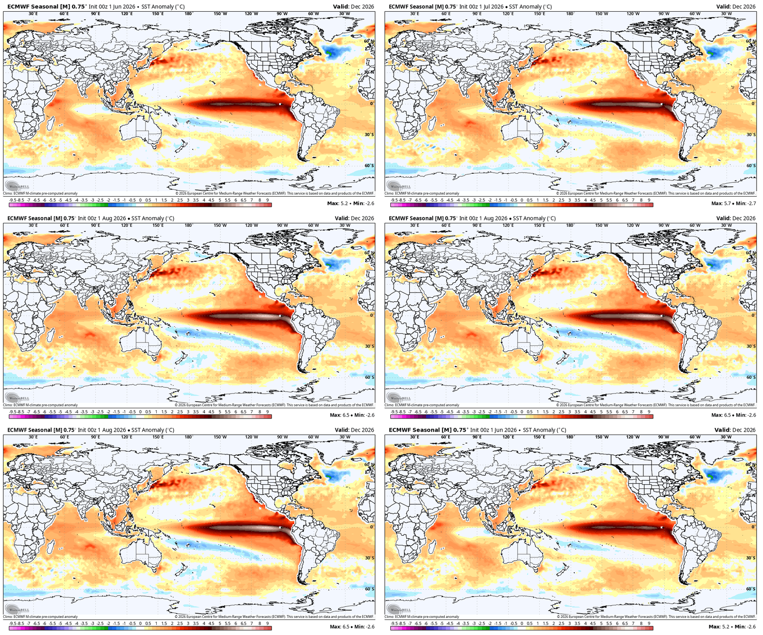
While I may not agree with the Euro verbatim, it’s a perfect example of how a stronger Nino doesn’t always mean warmer. The August update increased the strength but went cooler. -
Answer honestly. Did someone cut a 350 ft slice in the reflecting pool?
-
Half an inch MTD for August, mostly later yesterday. Not that things are drying out ... the dew points are back in the low 70's. Would you like a slice of air? :-)
-

2026-2027 Super El Nino
PhiEaglesfan712 replied to Stormchaserchuck1's topic in Weather Forecasting and Discussion
I wouldn't be surprised if we had a carry over el nino, like 87-88, in 27-28. But it's going to end early, and we're going to get a head start to a strong la nina like in 88-89, in 28-29. It will probably be a one-year la nina, but a very strong one. We'll get the 3rd el nino in the early 2030's, like 91-92 (but probably not with a major volcano). -
-
sick, gotta visit athens
-
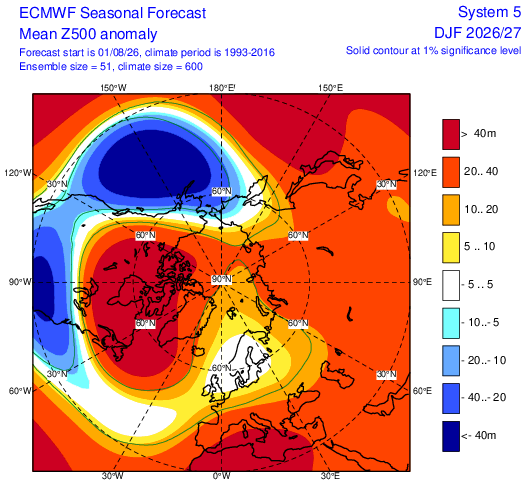
Gotta' love the Aleutian Low at 5H.
-

2026-2027 Super El Nino
GaWx replied to Stormchaserchuck1's topic in Weather Forecasting and Discussion
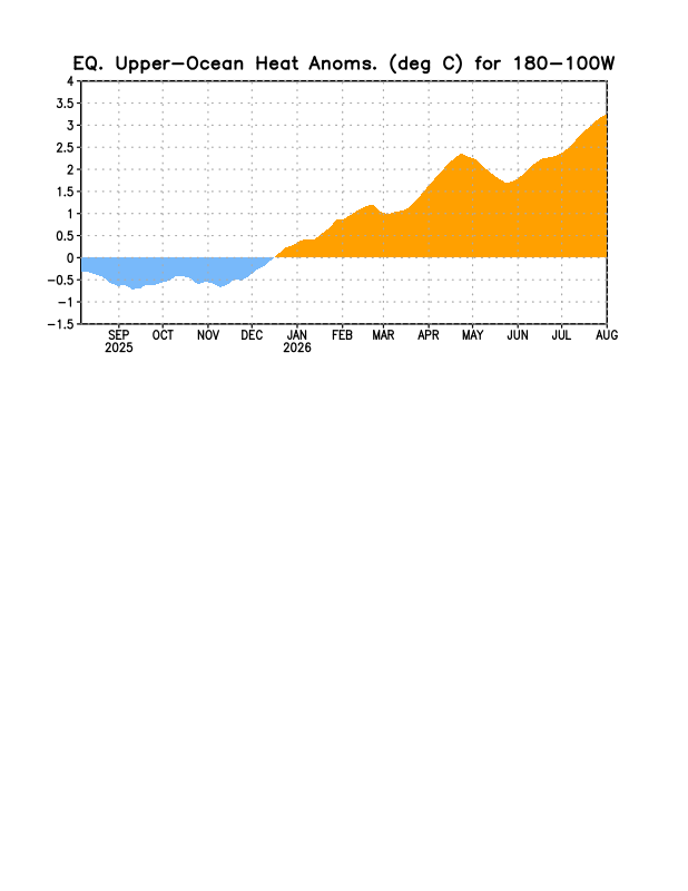
OHC is still rising and is now at insanely high levels (>+3), especially for early August! @snowman19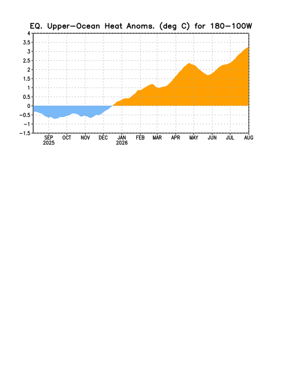
-
Yeah that is tasty looking, that makes me wonder what potential that may have for us back here in the Shenandoah Valley
-
That range is .5-1C.
-

2026-2027 Super El Nino
mitchnick replied to Stormchaserchuck1's topic in Weather Forecasting and Discussion
Some WB maps at this post.













.thumb.png.3513c28619bf91f0fa8e4004956c33df.png)