All Activity
- Past hour
-
It has been a struggle to get open in October in the 2020's but maybe this is the year. Maybe some cooler temps late in the month and Halloween on a Friday might create a marketing first day opportunity for SR and K.
-
You know the ground is dry when you go to water what's still surviving in your veggie garden and the water instantly repels off of the dirt.
-
Cat 2, 966 mb at 11 am
-
58/46. How Fall should be.
-
Grew up and remain a Reds fan. Adopted the Orioles as my second team when I moved here in 2009. I literally laughed out loud when this note hit my timeline this AM - Yep. That tracks.
-
Humbelda? But Humberto is likely already extratropical-it’s clearly a frontal cyclone now.
-
Extension of summer here for sure. It has been 90 or warmer a grand total of 3 times in October in Minneapolis. We could add 2 this year. The all time warmest overnight low for the month could be in jeopardy too. I still think we see a dusting of snow by Halloween.
-
Pressure dropped 3 mbs between passes, now down to 967
-
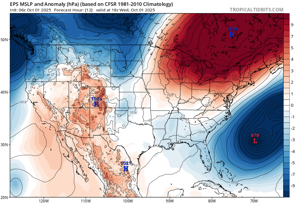
Very refreshing breeze today between the closest hurricanes on record in the satellite era and the big high to the north. Nice to get a few days closer to seasonable before the pattern warms back up again. Continuation of the dry pattern since September 2024.
-

September 2025 OBS-Discussion centered NYC subforum
Stormlover74 replied to wdrag's topic in New York City Metro
That or 3rd week of Jan -
From your lips to hopefully God's ears @George BM
-
https://x.com/andyhazelton/status/1973385028051636664?s=46&t=NyKvXvI1o-sJQb-68mmo4g
-
The southern side is much stronger right now and would be in line with the forward motion but models keep building a strong sting jet over the NW quad at some point near or over the island partly due to interaction with Humberto. Not a totally tropical evolution but one to watch to boost winds at a bad time for Bermuda. Imelda is trying to look pretty at the moment. Don’t think it holds this classic eye look for long though but it is definitely strengthening right now
-
I'm trying to live the lie that we still have real winters in this part of the world. Let me believe the hype for just a little bit longer.
-
September 2025 OBS-Discussion centered NYC subforum
anthonymm replied to wdrag's topic in New York City Metro
What do you think climatologically the snowiest week is? Second week of Feb would be my gut feeling. -
Seems like over them or just south of them is most likely at this point. Will be interesting to watch and see how this unfolds.
-
3.87" for the month (3.53" avg) 65.1 (66.8 avg) 50.6 +1 for 7am (48.8 avg) here in TH. A roller coaster month of very cool, and warm conditions. Was fortunate to get some decent rains, unlike others here in the sub.
-
a nice break from all the rainy months of the last few years
-
it was the perfect month
-

September 2025 OBS-Discussion centered NYC subforum
LibertyBell replied to wdrag's topic in New York City Metro
windy too but gorgeous but brrrrrrrrrrr lol -
Yeah in this case it will make quite a difference if the center passes north or south of them. North of them and it is with the motion of the storm.
-
Our lows are pretty cold because I’m in a deep, high valley (3800 feet, surrounded by 5500-6000 foot high mountains). On upslope snow days our temps get very cold also. The flora on my property is pretty similar I’d imagine to your area. A lot of Beech, Yellow Birch, Sugar Maple and Basswood.
-

September 2025 OBS-Discussion centered NYC subforum
LibertyBell replied to wdrag's topic in New York City Metro
the 80s were extremely cold, note how we did not have an August-September low couplet of 45 or colder after the 1980s. in your list it's only 1982, 1986, 1987 with that combo. Since then the next lowest couplet of August-September is 49 degrees (this year actually.) Besides this year and 2000 every year since 1987 has this couplet combo low of at least 50 or higher. -
Our rad pit didn't happen - low was a modest 39. We had 30 and 29 mornings on 20/21 last month. September numbers Avg max: 69.6 +1.5 Highest: 78 on the 28th, latest for a Sept max Avg min: 44.4 -1.3 Lowest: 29 on the 21st Mean: 57.0 +0.1 Precip: 3.89" +0.19", 1st AN month since May. Wettest day: 1.53" on the 25th. The 2.64" on 25-26 was 68% of the months rain. Other than the storm of 25-26, Sept 2025 continued the drought. Highest and lowest were modest, the availability of sunshine - 67% - was close to the most for Sept. The avg diurnal range of 25.2 was nearly 3° AN, this despite the 3° range on the rainy 25th, smallest diurnal range for any Sept day here.


