All Activity
- Past hour
-
That is true, but the same issue concerning measuring inconsistencies plagued Miller B events, as well.
-
You are correct regarding snow measurements. Back in the day the measurements were often taken after a storm had ended. I'll go to my grave stating the snowfall totals for the Merrimack Valley area for the Blizzard of 78 were on the low side..
-
I think the boundary just went through. Was overcast most of the morning and just had a thin line of showers go through. Mostly clear now. 51.4°
-
 The historically quiet Atlantic may have one final gasp before closing the door on the season, and this one is in the southwestern Gulf. Tropical Weather Outlook NWS National Hurricane Center Miami FL 800 AM EDT Mon Oct 5 2026 For the North Atlantic...Caribbean Sea and the Gulf of America: 1. Southwestern Gulf of America: A trough of low pressure in the southwestern Gulf of America is producing disorganized showers and thunderstorms. Although environmental conditions appear to be marginally conducive, gradual development is becoming more likely, and a tropical depression is likely to form during the middle or latter portion of the week. This system is expected to drift eastward over the next few days, before it turns northward. * Formation chance through 48 hours...low...30 percent. * Formation chance through 7 days...high...70 percent. Forecaster Kelly We've all been tracking this one for a few days, and while odds have significantly increased, there's still a fair amount of uncertainty on what this one could actually become. While development looks likely with the geographically favorable genesis location of the Bay of Campeche (the concave nature of the region promotes spin) alongside warm SSTs and an upper level pattern favorable for divergence (promoting strong convection) there are issues with westerly shear if the system is not perfectly aligned with the jet coming from the west and potentially dry air. Most guidance at least at the moment is modest in intensity as it pulls the eventual system northeast into the northern Gulf coast.
 -
October 15-20 has highs in the 50s and lows 30s and 40s according to 6z GFS.
-
Hopefully not a bunch of "almost no cigar" situations. Very frustrating
-
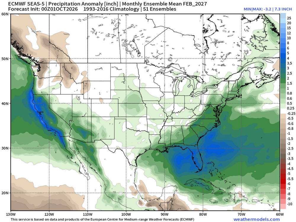
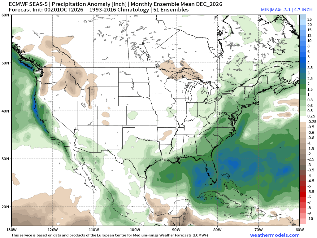
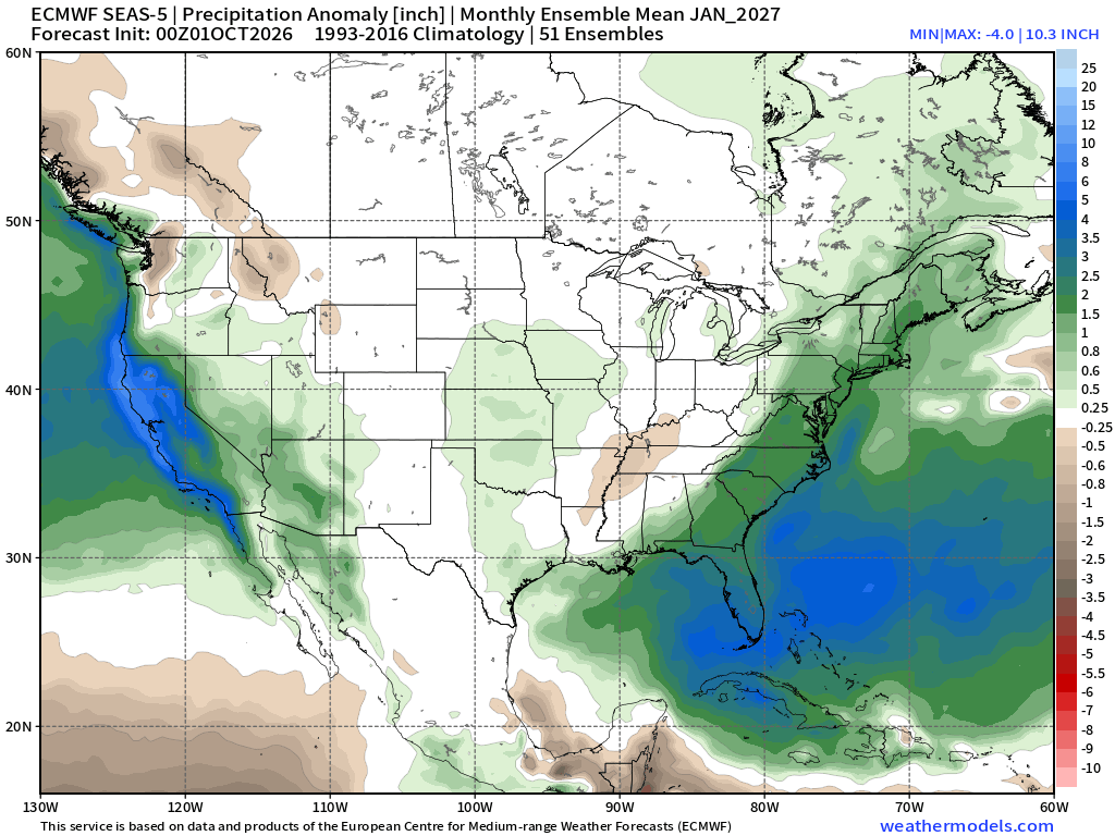
I believe @Weather Will and @CAPE would have monthly Euro seasonal maps. Hint, hint...!
-
Going to be hard to buy a cloud for most of this week.
-
That’s about what you’d expect. Can we time some cold with these storms or do we have benchmark rain events.
-
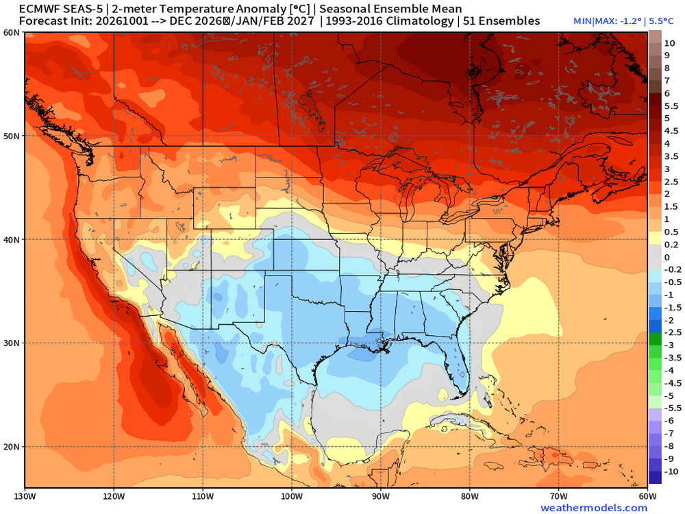
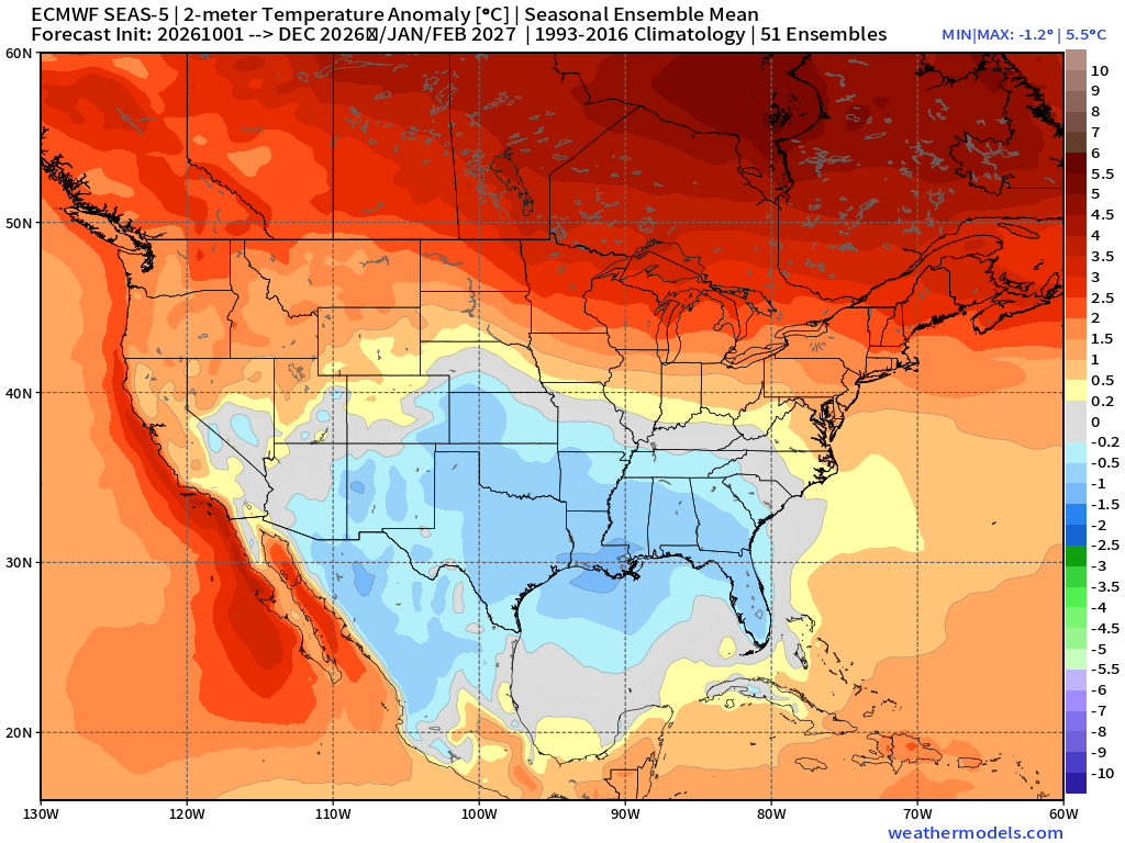
Whoops forgot...the DJF 2m Temp That is actually not terrible for a 3 mth Super El Nino winter.
-
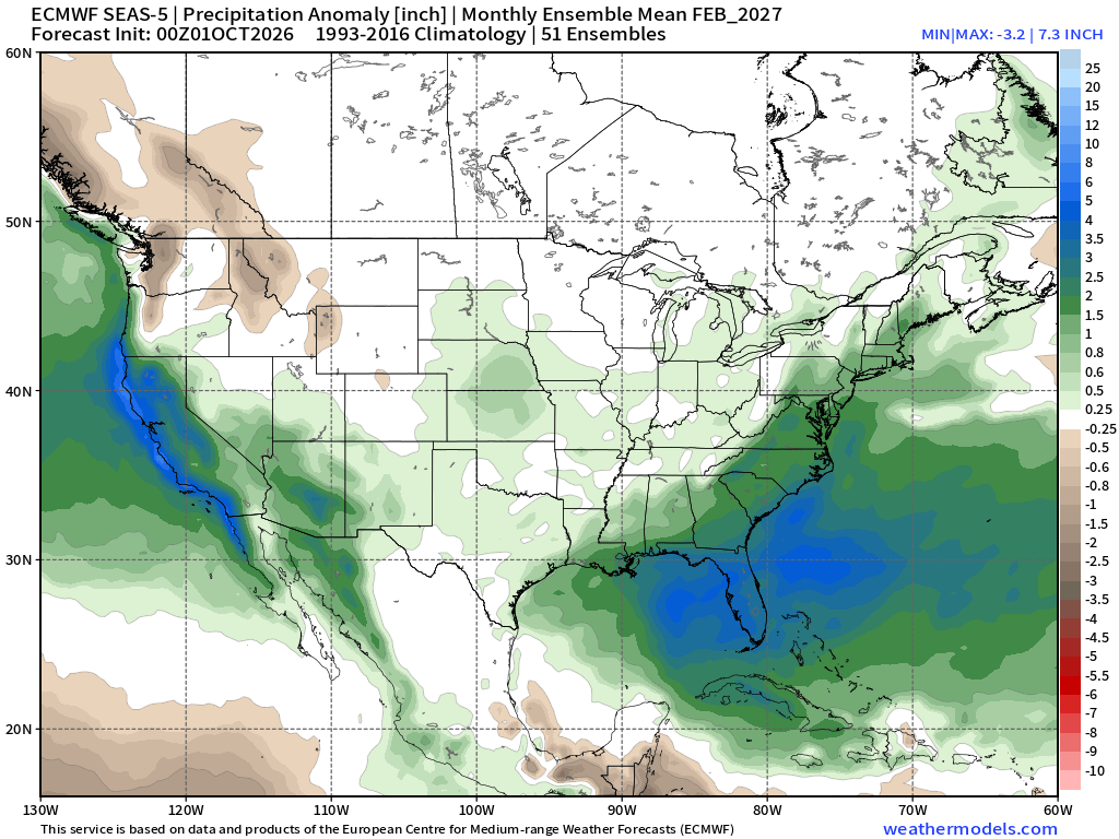
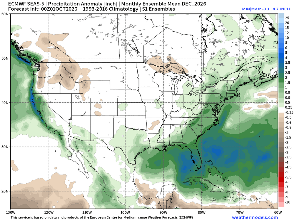
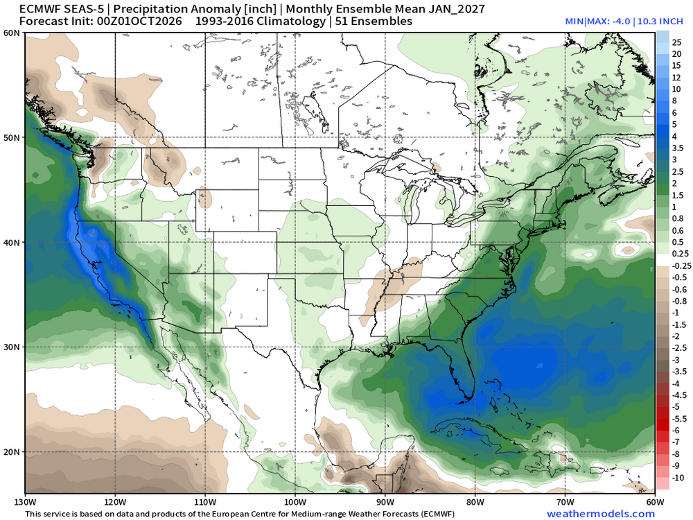
Updated October Euro seasonal out. Temos around the same as September.'s. But a little wetter than September. These maps are for DJF combined fyi. https://charts.ecmwf.int/products/seasonal_system5_standard_2mtm?area=NAME&base_time=202610010000&stats=ensm&valid_time=202612020000 https://charts.ecmwf.int/products/seasonal_system5_standard_rain?area=NAME&base_time=202610010000&stats=ensm&valid_time=202612020000
-
bullish on warmth until at least late month
-
51/51F, sun if peaking through as the morning fog finally lifts
-
TORCH!
-
EURO OCT UPDATE DEC JAN FEB
.thumb.png.7ef7181b2afdec818b3d55338543eb73.png)
.thumb.png.6d6b2f912aee30a8cafe864de8ccee78.png)
.thumb.png.463595596e0139705290da4de126c407.png)
.thumb.png.ebc4232ff5e1cfe66746d296a513d79e.png)
.thumb.png.2dbca217e77e74426dfcbac88da5c5e9.png)
.thumb.png.beb9e14bd78ea9ca74a6d07490ceca24.png)
-
Yes, let’s hope the sunny forecasts are actually sunny for once.
-
Coastal again possibly
-
Must've beeen distracted ... because the speed in which I've just realized we're moving through the solar transition season is something else. It just occurred to me we are closer to the solar minimum now, than the max, along that timeline journey.
-

Fall 2026 Medium/Long Range Pattern Thread
dwagner88 replied to John1122's topic in Tennessee Valley
Loved that wet weekend. Looks like next weekend may be even wetter. Tropical development seems inevitable at this point, and there really isn't anywhere else for the system to go except north. -
 cost of generic zithromax [url=http://rapidzithrodirect.com/#]RapidZithro Direct[/url] zithromax for sale usa
 -

2026 Atlantic Hurricane Season
eyewall replied to Stormchaserchuck1's topic in Tropical Headquarters
Good! I do not want to have to work this system lol. -
Future Isaias could be a ‘cane in the Gulf of Idiotic Arrogance before giving us some remnant rain in about a week? @WxWatcher007
-
Blazing out in Southern California but i suspect they will soon be much wetter later this month SoCal records, Oct. 2–4 October 2 Downtown LA: 103°F — new record, old 101°F Long Beach: 103°F — new record, old 98°F Burbank: 102°F — tied record Santa Ana: 105°F — new record, old 101°F Anaheim: 103°F — new record, old 101°F San Diego: 95°F — new record, old 94°F Chula Vista: 99°F — new record Vista: 100°F — new record Escondido: 105°F — tied record Newport Beach: 85°F — tied record CBS News October 3 Downtown LA: 104°F — 4°F short of daily record 108°F (1987) San Diego: 105°F — new record, old 104°F (1987) Oceanside: 105°F — new record, old 94°F — smashed by 11°F Fullerton: 105°F — new record, old 103°F Escondido: 108°F — new record Ramona: 105°F — new record Riverside: 106°F — new record Santa Ana: 105°F — near-record territory Santee area: 112°F — one of the hottest readings anywhere in the U.S. that day; the national high reported by NOAA/WPC was 112°F near Santee. WPC NCEP October 4 San Diego: 100°F — new record, old 97°F Burbank: 101°F — new daily record Camarillo: 99°F — new daily record NWS Oxnard: 99°F — new daily record
-
nice to see a dry week on tap...we are still quite waterlogged here
- Today
-
There aren’t really any inverse temperature correlations between October and the winter. When relationships do exist, it’s more on a CONUS and North American level of similar October to winter temperatures. For instance very warm Octobers across the CONUS and North America sometimes continue into the winter. Same for very cold Octobers continuing into the winter. Our last much weaker super El Niño in 2023 -2024 had a very warm October in the Northeast and this continued for the winter. Other times the October pattern doesn’t continue into the winter. So it’s mostly magnitude dependent across a larger area.











.png.31911f6d9b631f68452014fe967ebab5.png)
.png.aeab6490278f367f5b3f41a5517685c0.png)
.png.962bad804729c999844d9cf26f052df5.png)
.png.dd65ee3b3526cfc9129fefdd3dfe1157.png)
.png.0087d4983b5fd501e63a96ae8460afde.png)
.png.0ae2eb9d908c04b5d62512d3a99fc335.png)