All Activity
- Past hour
-
Looking at RadarScope again I think it’ll scoot to my west, but I’ve heard rumbles in the distance, so who knows.
-
CT should be ok by Sat late morning but AEMATT may have a wettie
-
Storm total here now .92
-

2025 Lawns & Gardens Thread. Making Lawns Great Again
Brewbeer replied to Damage In Tolland's topic in New England
mine's getting long and it's only Cinco de Mayo ! -
Just reported Nickel size hail in the cell that popped up basically over my house in Stafford, near Hartwood, VA.
- 472 replies
-
- 2
-

-
- severe
- thunderstorms
- (and 2 more)
-

E PA/NJ/DE Spring 2025 Obs/Discussion
ChescoWx replied to PhiEaglesfan712's topic in Philadelphia Region
0.23" of rain since this morning here in East Nantmeal this brings our 3 day total up to 1.51" of rain. -
@aldie 22 gonna get recked
-
Yeah I saw that. Told my kid that it would slip to the N. Just got put under a warning for it by a sliver.
-
.thumb.jpg.6a4895b2a43f87359e4e7d04a6fa0d14.jpg)
Central PA Spring 2025
Yardstickgozinya replied to canderson's topic in Upstate New York/Pennsylvania
I also love my mistakes corrected in a civil manner. Be a dick get a dick has always been my philosophy. -
It's actually getting weird...the cell by Brunswick is heading ne while almost every storm has gone nw. This area has been a storm magnet today.
-
You will take your watch and like it good sir
-
2-3' on the GFS end of the week into Saturday. Deformation and ratios TBD.
-
- 472 replies
-
- 1
-

-
- severe
- thunderstorms
- (and 2 more)
-
Central PA Spring 2025
Yardstickgozinya replied to canderson's topic in Upstate New York/Pennsylvania
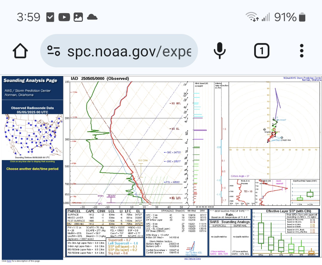
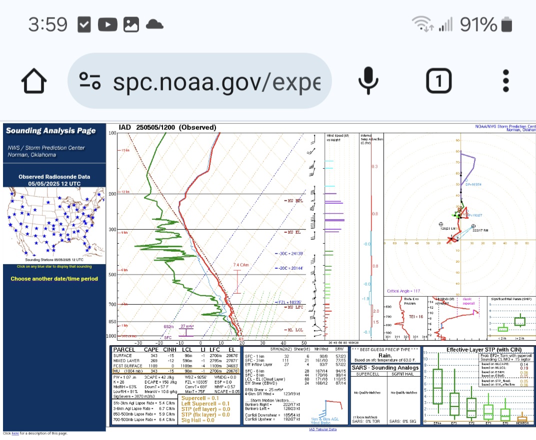
Once again, I'm not claiming to be anything close to Ace, but I enjoy pretending, lol. To my amateur eye, IAD just needed a little more veering to the north in the mid to upper levels and a little cooling above 250mb, and IAD would have had some sig hail issues today . Unfortunately, the latest sounding for IAD has lost most of its juju and really narrowed the cape field down to a sliver. Im assuming the warming above 225mb and those little inversions from about 675mb down to 950mb are a marine layer and to blame . I realize we are not in Baltimore, but it's the closest observed sounding I know of to practice with. I'm not ruling out any thunderstorms or rain this evening just pointing out something I noticed at IAD.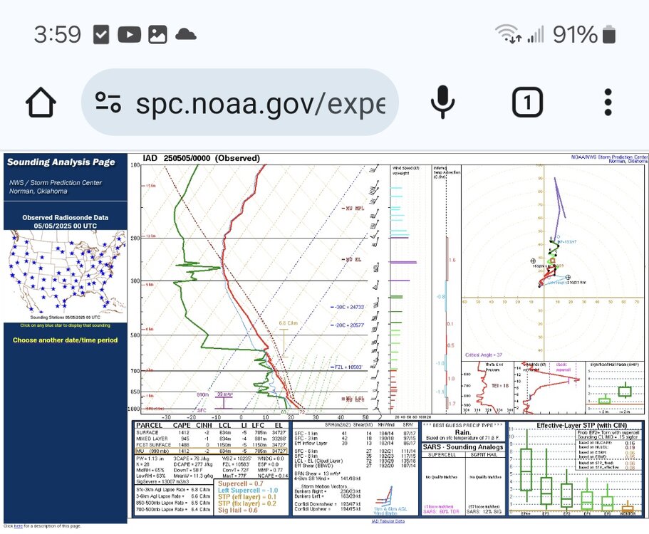

-
40/20 on both hail and wind probs... 20 on 2 or more tornadoes probs
-
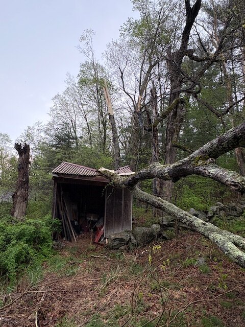
Looks like 65 mph type stuff. Wish that could happen here . Shed looks salvageable?
-
Watch up until midnight
-
Watch up until midnight URGENT - IMMEDIATE BROADCAST REQUESTED Severe Thunderstorm Watch Number 228 NWS Storm Prediction Center Norman OK 600 PM EDT Mon May 5 2025 The NWS Storm Prediction Center has issued a * Severe Thunderstorm Watch for portions of District Of Columbia Maryland Southern Pennsylvania Northern and Eastern Virginia Eastern Panhandle West Virginia Coastal Waters * Effective this Monday night from 600 PM until Midnight EDT. * Primary threats include... Scattered damaging wind gusts to 70 mph possible Scattered large hail events to 1.5 inches in diameter possible A tornado or two possible SUMMARY...Scattered linear clusters of strong to severe thunderstorms will likely develop and move northward into the Watch area this evening. A few of the stronger cellular storms will pose a risk for large hail (1 to 1.5 inches in diameter). A transient supercell or two is possible in addition to a couple of line segments. Strong to severe gusts capable of wind damage will be the primary hazard with these storms, but a brief tornado is possible mainly early this evening with this activity. The severe thunderstorm watch area is approximately along and 60 statute miles east and west of a line from 35 miles east northeast of Hagerstown MD to 25 miles southwest of Patuxent River MD. For a complete depiction of the watch see the associated watch outline update (WOUS64 KWNS WOU8).
-
that tree was ready to go. meh
-
off and on tropical downpours here all afternoon
-
There was a tornado in Shoemakersville, Berks County also.
-
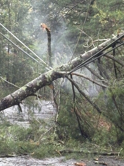
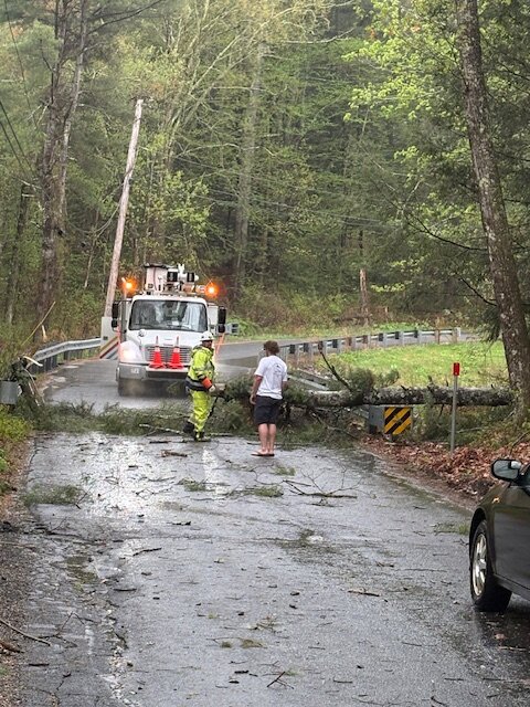
O.K. Damage-Devas-- The scene from Monson after Saturday's violent down-burst. The smoke in one of the pics is from a live wire--
-
Hopefully this juices up more over the next few runs

-
Line of storms near RIC looks like a good track for Frederick!
-
Watch potentially coming soon Mesoscale Discussion 0701 NWS Storm Prediction Center Norman OK 0429 PM CDT Mon May 05 2025 Areas affected...Parts of the Mid-Atlantic Concerning...Severe potential...Watch possible Valid 052129Z - 052330Z Probability of Watch Issuance...60 percent SUMMARY...Thunderstorms moving north out of southeast Virginia will migrate into a buoyant air mass in place across the DelMarVa region. Re-intensification is expected and may result in an uptick in the severe hail/wind threat. Watch issuance is being considered to address this potential. DISCUSSION...A mix of semi-discrete thunderstorms and weakly organized linear segments continues to migrate north out of southeast VA. While a few stronger cores persist, much of the convection currently appears weak/disorganized based on GOES IR imagery and MRMS vertical ice/echo top data. However, these storms are moving into an environment characterized by better buoyancy (MLCAPE between 1000-2000 J/kg) that is in place across the DelMarVa region. Consequently, some uptick in intensity is anticipated within the next 1-2 hours. Deep-layer wind shear sampled by regional VWPs is fairly modest - around 20-25 knots of 0-6 km BWD. However, this should be sufficient for a few organized cells and linear segments capable of producing damaging winds and 1.0 to 1.5 inch hail. ..Moore/Smith.. 05/05/2025 ...Please see www.spc.noaa.gov for graphic product... ATTN...WFO...PHI...AKQ...CTP...LWX... LAT...LON 37687760 38617858 39057882 39307881 39677865 39997827 40077798 40057760 39837722 39257636 38867603 38407592 38117592 37777606 37557624 37357656 37357685 37467726 37687760 MOST PROBABLE PEAK TORNADO INTENSITY...UP TO 95 MPH MOST PROBABLE PEAK WIND GUST...55-70 MPH MOST PROBABLE PEAK HAIL SIZE...1.00-1.75 IN
- 472 replies
-
- 1
-
-
- severe
- thunderstorms
- (and 2 more)