All Activity
- Past hour
-

Nov 28-30th Post Turkey Day Wintry Potential
ChiTownSnow replied to Chicago Storm's topic in Lakes/Ohio Valley
Thanks for the clarification. I just saw those maps as well and was a little surprised at those numbers. -
Nice to finally have a reason to watch December models. Been awhile.
-
12z Icon went bad on us. Nothing. Big shift north.
-
Maybe, but there is pretty much 0 operational support for an OTS solution.
-
GFS was around 1.3" + for some areas.
-
Absolutely.
-
Over 1.5” liquid in the interior. Good luck with that.
-

Nov 28-30th Post Turkey Day Wintry Potential
ILSNOW replied to Chicago Storm's topic in Lakes/Ohio Valley
Ricky what are you thoughts? -
.thumb.png.4150b06c63a21f61052e47a612bf1818.png)
December 2025 regional war/obs/disco thread
HIPPYVALLEY replied to Torch Tiger's topic in New England
That will crush the interior. -
December 2025 regional war/obs/disco thread
HIPPYVALLEY replied to Torch Tiger's topic in New England
I would say Saturday is thread time. That’s getting well within a goal post window. -
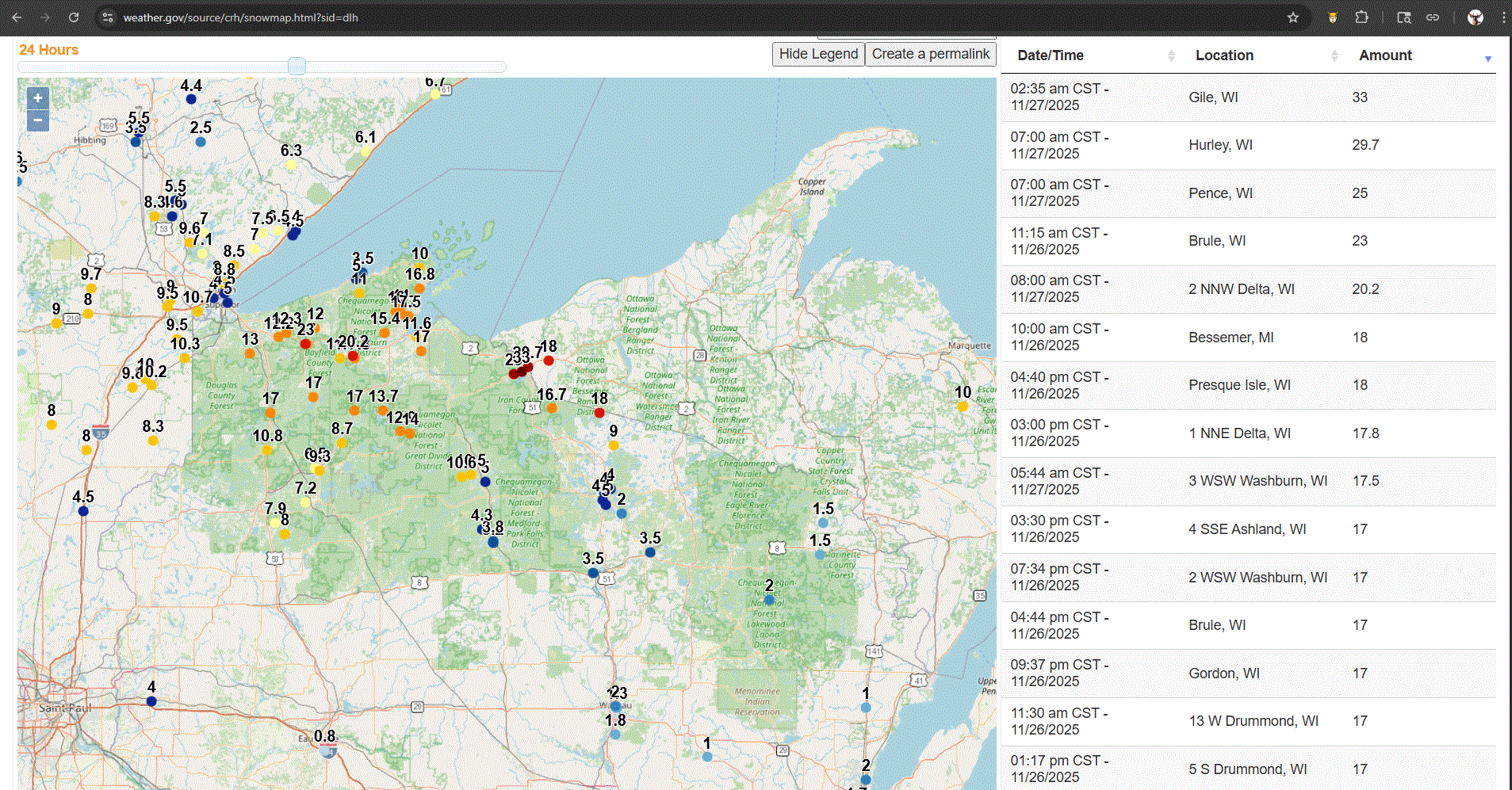
Pretty good hit for N WI folks.

-

Nov 28-30th Post Turkey Day Wintry Potential
RCNYILWX replied to Chicago Storm's topic in Lakes/Ohio Valley
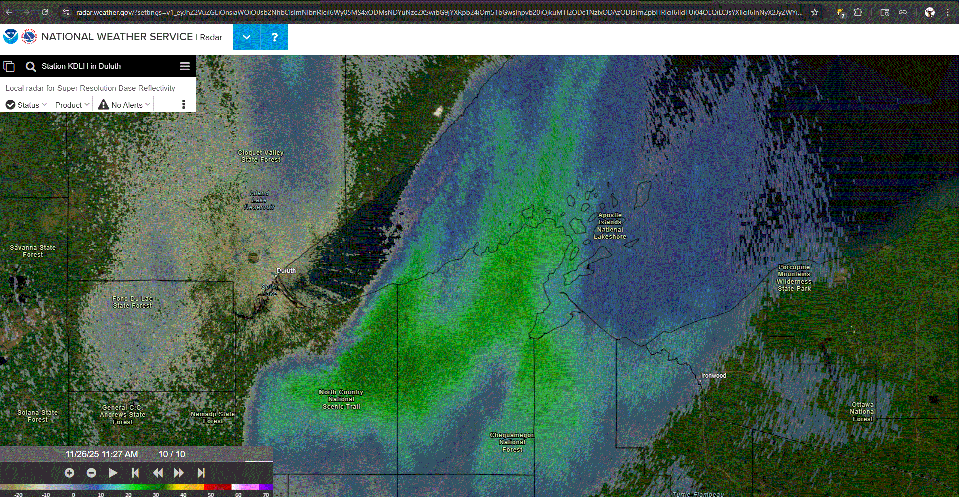
The top end range on the "official NWS forecast" graphic is the 75th percentile of the NBM distribution and the low end is the 25th percentile. Point and click is still quite high and possibly/likely overdone and our (LOT CWA) overnight forecaster did some work to rein it in a bit even. Looks like DVN made less adjustments to the initialized data so they have a large area of 12"+. I can say, speaking for my office, that we all strongly dislike the probabilistic winter page but unfortunately we don't have control over what's displayed on it. -
So far this month, IAD and DCA have had 0.83 and 0.84 inches of rain - while Tucson got 1.15 and Phoenix 0.79!
-
Same here verbatim, Its a fast mover as well but it would be some high rates.
-
Foot plus here we pray
-
987mb over the cape.
-
12z ICON not backing down atleast
-
it's too far to know this storm could whiff to the south
-

December 2025 regional war/obs/disco thread
Sey-Mour Snow replied to Torch Tiger's topic in New England
Going to be hard to get all snow south of rt 2 and 84 with the latest trends the past 18 hours. Verbatim that 6z euro wouldn’t be as good south of 84. 2-4” then ice and rain as the mid levels are torched by then . Let’s get that high to start trending to stick around for longer! -
Getting some flurries now with a temp of 28 degrees! Just blowing around but nice to see.
-
You guys made me look at the Gem. Dang, that's a dream.
-

Occasional Thoughts on Climate Change
TheClimateChanger replied to donsutherland1's topic in Climate Change
While some like to pretend nothing happened before 1979, never forget that the Arctic sea ice was once FAR, FAR more prolific, encircling Iceland year-round in colder years. -

2025-2026 ENSO
donsutherland1 replied to 40/70 Benchmark's topic in Weather Forecasting and Discussion
I'm not that surprised. The 11/27 0z cycle reflects yesterday's development where the GEFS backed off its development of a pronounced AO+ pattern. It is trying to push an EPO+, but its 500 mb pattern is profoundly different from any of the December WPO-/EPO+/AO-/PNA- clusters. Assuming that the simplest explanation is more likely, the pattern disconnect from its forecast teleconnections suggests that either the teleconnection idea is off or the pattern is off, rather than some novel outcome. The pattern closely resembles the EPS, which does not show an EPO+ pattern. Thus, I suspect that the EPS has a better handle on the overall pattern right now. The northern tier of the U.S. and most of Canada should remain cold toward and probably beyond mid-month if that holds. Unfortunately, the SE could still turn warm despite some shots of colder air. -
BWI: 19.2" DCA: 11.6" IAD: 22.3" RIC: 9.8" SBY: 11.7"
-

November 2025 general discussions and probable topic derailings ...
ineedsnow replied to Typhoon Tip's topic in New England
Models trying to get a lake band somewhere into SNE tomorrow