All Activity
- Past hour
-

The Jan 31 Potential: Stormtracker Failure or 'Tracker Trouncing
Climate175 replied to stormtracker's topic in Mid Atlantic
I admit I asked it myself but it literally was for a laugh lol. Back to regular scheduled programming. -

E PA/NJ/DE Winter 2025-26 Obs/Discussion
snowwors2 replied to LVblizzard's topic in Philadelphia Region
I dipped to -6.2° on 1/21/26‼️ -

The “I bring the mojo” Jan 30-Feb 1 potential winter storm
Buddy1987 replied to lilj4425's topic in Southeastern States
0z RGEM at 66 looks better over the Midwest but heights are pretty flat in the northeast. Compared it to the GFS at the same time at 18z and there’s a pretty noticeable difference. Let the rest of the run play out and see if it improves. -

The Jan 31 Potential: Stormtracker Failure or 'Tracker Trouncing
Solution Man replied to stormtracker's topic in Mid Atlantic

-

The Jan 31 Potential: Stormtracker Failure or 'Tracker Trouncing
bncho replied to stormtracker's topic in Mid Atlantic
Whatever the RGEM shows will be shown on the CMC. -

The Jan 31 Potential: Stormtracker Failure or 'Tracker Trouncing
Weather Will replied to stormtracker's topic in Mid Atlantic
OZ ICON does bring snow to eastern NC. 18Z did not. -

The Jan 31 Potential: Stormtracker Failure or 'Tracker Trouncing
stormtracker replied to stormtracker's topic in Mid Atlantic
Yeah, I'm waiting to see what it does when it forms the closed low -

The Jan 31 Potential: Stormtracker Failure or 'Tracker Trouncing
DDweatherman replied to stormtracker's topic in Mid Atlantic
Should give it move time to round the base and try to get negative for us. -
The earlier/further west the ull pinches off, the better our odds of getting some decent qpf thrown our way. Unfortunately, the ICON does it over Virgina and we get nothing. Fortunately, it's the ICON.
-

Richmond Metro/Hampton Roads Area Discussion
RVASnowLover replied to RIC Airport's topic in Mid Atlantic
Take this back. Actually gets some snow into RIC. Not a lot but not nothing -

The Jan 31 Potential: Stormtracker Failure or 'Tracker Trouncing
Ephesians2 replied to stormtracker's topic in Mid Atlantic
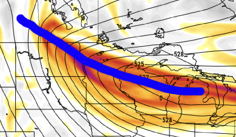
So at 72h... the RGEM looks even further west with the NS energy than even the GFS/NAM EDIT: it is flatter in front though
-

E PA/NJ/DE Winter 2025-26 Obs/Discussion
RedSky replied to LVblizzard's topic in Philadelphia Region
Meh try one more time -

The “I bring the mojo” Jan 30-Feb 1 potential winter storm
kvegas-wx replied to lilj4425's topic in Southeastern States
You have my attention! Great find. I figured for sure the data wouldn't be included until tomorrow. Lets see where we land at 6z! -
All you can ask for at this point
-
I have seen systems like this stop right at the crest of the Apps. I do think we see some light snow from the northern stream. I remain unconvinced this gets enhanced by the Atlantic...for most of E TN (edit). Backing would help prolong the light snow. I think those high end amounts are incredibly unlikely unless that slp shifts to the coast or just inland. I could see far E TN counties benefiting for sure due to orographic lift. This looks like "an east of I81" type of storm - so far. Tomorrow likely dials in this track. Need some big moves overnight for anyone west of the foothills to score more than 1-2" with this.
-

The Jan 31 Potential: Stormtracker Failure or 'Tracker Trouncing
Nomz replied to stormtracker's topic in Mid Atlantic
I was more looking at the western extent of the northern vort. Looked a little bit closer to negative too imo. (Icon left gfs right)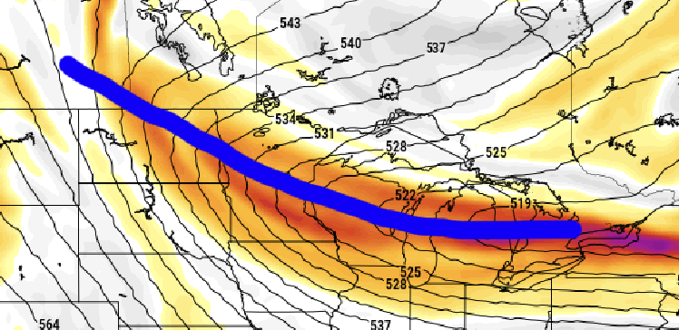
-
The Jan 31 Potential: Stormtracker Failure or 'Tracker Trouncing
Buddy1987 replied to stormtracker's topic in Mid Atlantic
I just looked at it and compared to the 18z gfs. Looks like we would want heights to rise a good bit more in the northeast. 0z RGEM pretty dang flat but yes it does look better in the Midwest. -

Possible coastal storm centered on Feb 1 2026.
Go Kart Mozart replied to Typhoon Tip's topic in New England
ICON keeps the 500 closed low north of the Tidewater, rather than over Savannah. A rather radical change, I would think. Edit: Not a huge change over itself, but far from the look of every other model. -
It improved .
-

The Jan 31 Potential: Stormtracker Failure or 'Tracker Trouncing
Cobalt replied to stormtracker's topic in Mid Atlantic
Weren't you just talking to a robot asking it to share secrets about the Weathernext's 18z run? -
I like your spunk
-

The Jan 31 Potential: Stormtracker Failure or 'Tracker Trouncing
jayyy replied to stormtracker's topic in Mid Atlantic
The icon has never once, in its entire existence, spoken. -
To me looks a move towards the GFS. Negative tilt & powers further west.
-
That's an interesting idea because that is basically what you see on the weeklies. It just locks in and stays similar for the rest of Feb and into March.
-
The Jan 31 Potential: Stormtracker Failure or 'Tracker Trouncing
stormtracker replied to stormtracker's topic in Mid Atlantic
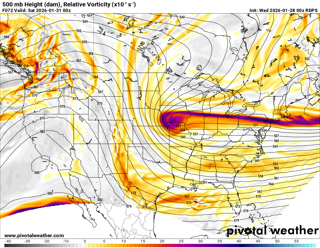
RGEM now is noticeable further west- 204 replies
-
- 11
-