All Activity
- Past hour
-
I would call last Dec pretty solid given the run of next to nothing prior to that. An inch+ on the 5th and then a solid coating on the 31st here.
-

Septorcher 2026 Discussion - Endless Summer
kdxken replied to Damage In Tolland's topic in New England
Anybody hear from Torch Tiger today? -

Septorcher 2026 Discussion - Endless Summer
SJonesWX replied to Damage In Tolland's topic in New England
3/4”, nice drink -
Latest Natty Blend
-
Septorcher 2026 Discussion - Endless Summer
kdxken replied to Damage In Tolland's topic in New England
You said that. Drunk? -
I'm not asking for big snows in December. Just a solid advisory level event regionwide would be amazing.
-

Septorcher 2026 Discussion - Endless Summer
Damage In Tolland replied to Damage In Tolland's topic in New England
Ineedsnow gone wild -
Septorcher 2026 Discussion - Endless Summer
kdxken replied to Damage In Tolland's topic in New England
I wouldn't call it perfection but it's better than it was. Hate losing Sunday. -
Septorcher 2026 Discussion - Endless Summer
Damage In Tolland replied to Damage In Tolland's topic in New England
Cane -
Tomorrow will see temperatures top out in the upper 70s. Cooler air will return for the weekend. A rainy period could develop late Sunday and continue into early next week. Temperatures will remain unseasonably cool. The chance that the region could see its coolest air mass this fall arrive toward midweek next week has increased. The ENSO Region 1+2 anomaly was +4.5°C and the Region 3.4 anomaly was +2.9°C for the week centered around September 9. For the past six weeks, the ENSO Region 1+2 anomaly has averaged +4.23°C and the ENSO Region 3.4 anomaly has averaged +2.65°C. The ongoing strong El Niño, will continue to strengthen through the mid-fall. The SOI was -31.02 today. The preliminary Arctic Oscillation (AO) was +2.934 today. Based on sensitivity analysis applied to the latest guidance, there is an implied near 55% probability that New York City will have a cooler than normal September (1991-2020 normal). September will likely finish with a mean temperature near 69.0° (0.2° below normal). Supplemental Information: The projected mean would be 1.0° above the 1981-2010 normal monthly value.
-
Septorcher 2026 Discussion - Endless Summer
Damage In Tolland replied to Damage In Tolland's topic in New England
Soakah.. and look at MTD after a very wet Augdewst . Drought gone there!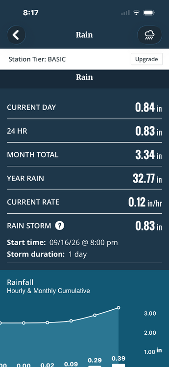
-
It is kinda uncanny in the MA around Christmas. It can be cold AF the week before and it still find a way to be warm during at least part of the holiday week. Especially xmas eve or day... lol. Christmas 2009 was the least memorable and kinda sad white Christmas I've had. Watching a 24" snowstorm just 7 days prior get literally nuked with fog and rain was a little depressing. And we rarely get a white chistmas. Like I cant even remember the last legit region wide one. But I can sure remember a lot of unseasonably warm ones haha. The WDI index has been screaming for a white Christmas for years but for some reason.... we never even get close. Often not even a frosty morning that you can squint and pretend.
- Yesterday
-
My house and property are swarmed with spotted lanternflies now.
-

Central PA Summer 2026 Discussion/Obs Thread
Voyager replied to Voyager's topic in Upstate New York/Pennsylvania
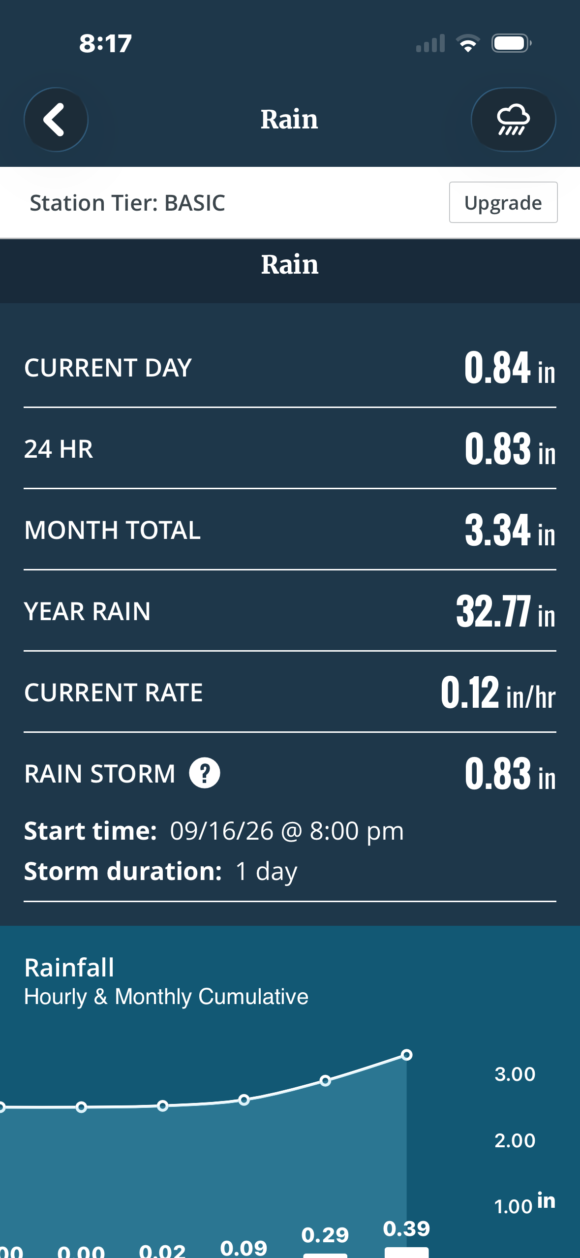
I got 0.09" today. Morning line fell apart, and this one was just a miss to the left (west). -
-

Septorcher 2026 Discussion - Endless Summer
ineedsnow replied to Damage In Tolland's topic in New England
rains for days at the end of next week on the 18z Euro AI -
Brutal run if true
-

Central PA Summer 2026 Discussion/Obs Thread
mahantango#1 replied to Voyager's topic in Upstate New York/Pennsylvania
Just got 1.28 rain from this batch headed towards Harrisburg area. Complete with several bouts of thunder. It poured. 1.40 for the day. -

2026-2027 Fall/Winter Mountain Thread
buckeyefan1 replied to BlueRidgeFolklore's topic in Southeastern States
CAUTION FOLKLORE—-> I know that you’re supposed to wait until after the first frost, but the persimmons have spoons and the one woolly worm I saw was black Don’t judge I gotta do what I gotta do when it’s the end of September and we’re still 20+ degrees above average every single freaking day -
I think the warm Xmas puns a play off the warm December that is expected....I don't think anyone it honestly trying to forecast down to the day at 3 months out.
-
I don't think you are paying enough attention to antecedent conditions...of course the summer of 2015 was more redolent of El Niño....it came off of....an El Niño with a huge +PDO. You are also misunderstanding what I am saying when I compare to 2015...not just talking about the intensity of the GOA low, but also the degree of MC influence. There is probably a connection, but it's not 1:1. I doubt we see more MC influence than 2015.
-

Septorcher 2026 Discussion - Endless Summer
Lava Rock replied to Damage In Tolland's topic in New England
Missing the good stuff. 0.01". Sent from my SM-S921U using Tapatalk -
DC might be better at sports than we are at December snow.
-

Central PA Summer 2026 Discussion/Obs Thread
canderson replied to Voyager's topic in Upstate New York/Pennsylvania
Yea but 82/76 which is what I’m at now is really gross. -

2026-2027 Record-breaking El Nino
GaWx replied to Stormchaserchuck1's topic in Weather Forecasting and Discussion
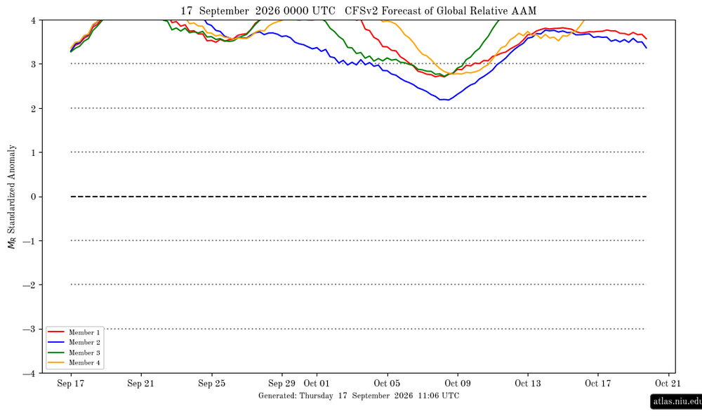
Indeed, the weighted avg of your graph, which looks like it is only ~+1.25 to 1.5, doesn’t at all jibe with the image below, which shows it ~+3.3: