MOD
-
Posts
52 -
Joined
-
Last visited
About MOD

- Birthday 02/02/1972
Recent Profile Visitors
2,687 profile views


-
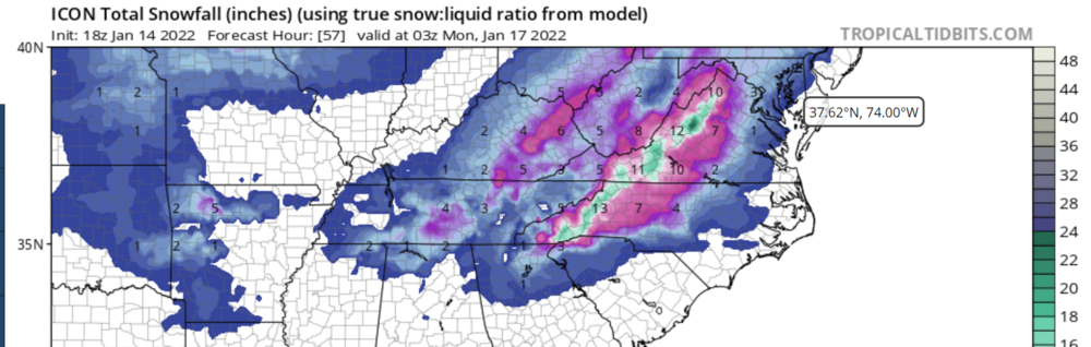
To no one's surprise here in NC, i heard that there were at least some flakes flying in the air today in Roxboro as the line moved through.
-
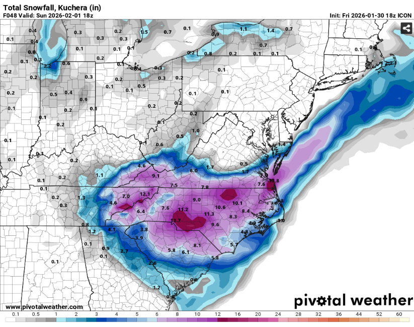
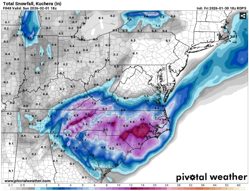
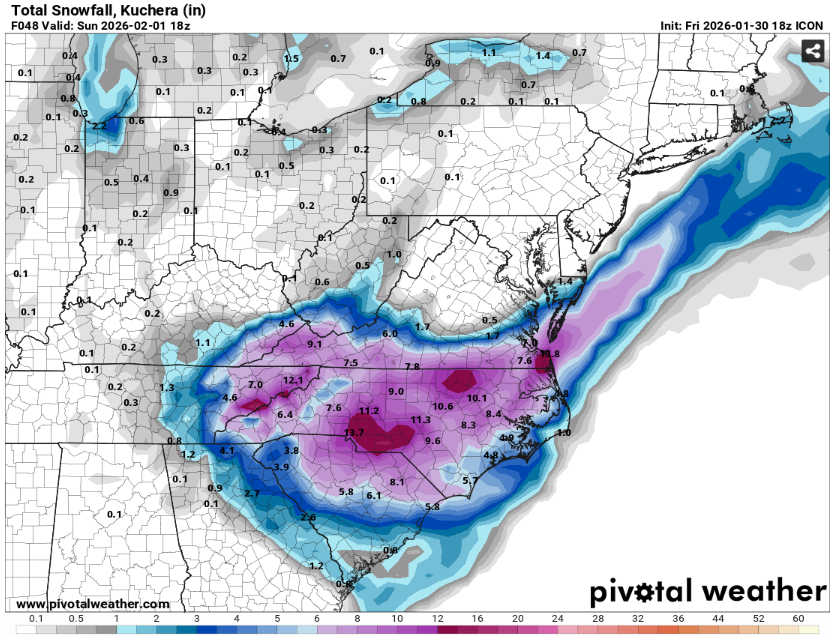
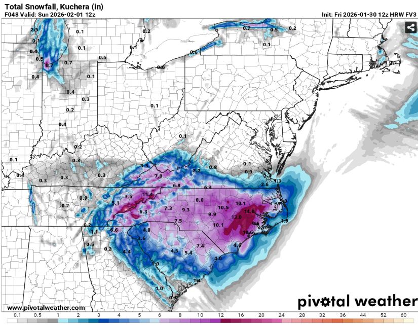
The “I bring the mojo” Jan 30-Feb 1 potential winter storm
MOD replied to lilj4425's topic in Southeastern States
-
The “I bring the mojo” Jan 30-Feb 1 potential winter storm
MOD replied to lilj4425's topic in Southeastern States
-
The “I bring the mojo” Jan 30-Feb 1 potential winter storm
MOD replied to lilj4425's topic in Southeastern States
-
The “I bring the mojo” Jan 30-Feb 1 potential winter storm
MOD replied to lilj4425's topic in Southeastern States
-
Not sure where to put this. Mods, please move if you feel it should go elsewhere. I just saw this today and wanted to make people aware. The AFD format will be changing on 1/12/2026. https://www.weather.gov/media/rah/modernizedAFD.pdf
-
Speaking of NWS for RAH, they issued briefing 3 just before noon today on the possible impacts. This format is more thorough than in previous years. http://www.weather.gov/media/rah/briefing/NWSRaleighLatestBriefing.pdf
-
January 20-22 “bring the mojo” winter storm threat
MOD replied to lilj4425's topic in Southeastern States
I would say the odds are greater than zero, but couldnt say how high they are. My suggestion would be to ask yourself how late can you make the decision to drive? Based on forecast uncertainty and how long it may take to iron things out, you may have to decide to drive before the forecast is more settled. -
So, a foot or so of snow, 2 inches of sleet, and a trace of ice? Prime sledding conditions for you if it comes close to verifying. Rooting for you in the GSP metroplex.
-
I think the sleet would meet warning criteria. Also not sure how a mix of all are handled.

-
-
I have been watching the nam runs too (both lo and hi res) and was thinking same thing. They both look very HRRR like. Not out to 48 yet for full comparison, however.
-
Harkens back to Cold War days and the perception or possibly the fact that certain judges from the communist block would tend to score western athletes lower than average in world championship and Olympic events where judging matters. In this context, I would assume the poster was indicating others may rate the tornado ef2 even though some may think it should be higher.
-
-