All Activity
- Past hour
-
My P&C hourly forecast calls or another 0.25" of zr on top of what we've already gotten which I'm guessing is probably between 0.1 and 0.2" on top of about 4" of snow. They also dropped my low temp holding it steady at 30F down to 26F in the early morning hours. This might get interesting.
-
This weather blows. Nothing more depressing and a foggy, gray, wet 40 degree day. I fear this boundary is just gonna set up shop over us for the next week. Maybe I should plant some grass seed.
-
it's snowing outside
-
Based off a LR OP run?
-
The area just north of Vermont and NH was the areas in Quebec that were real bad..St Zenon, St Donat those areas were the theft areas with the Indian reservations. I’m a little surprised up in NB…but It can happen obviously.
-
Scooters got 50’s by 9:00 AM. You good
-
Might be a few hours of clearing after the rain. Could briefly make icy in those spots near 32 as we radiate a tad.
-
As the Jon Voight character said to Ned Beatty's character in Deliverance, "we're not out of this yet".
-
Iced up here…but haven’t been out since 3 o clock, so I don’t know how conditions are. School delays in the am..?
-
The trailer too but that was found in time for me to bring it back with me last weekend.
-

Central PA Spring 2026 Discussion/Obs Thread
Blizzard of 93 replied to Voyager's topic in Upstate New York/Pennsylvania
More on the Winter comeback potential from @bncho in the Mid Atlantic thread… Euro AI has back to back hits. -

2/24 - 2/25 Clipper Obs (1 - 2" for many on forum)
The 4 Seasons replied to Northof78's topic in New York City Metro
This event is now up on the archive as the 12th 3"+ of the season with radar/sfc/upper air maps https://www.jdjweatherconsulting.com/feb-25-2026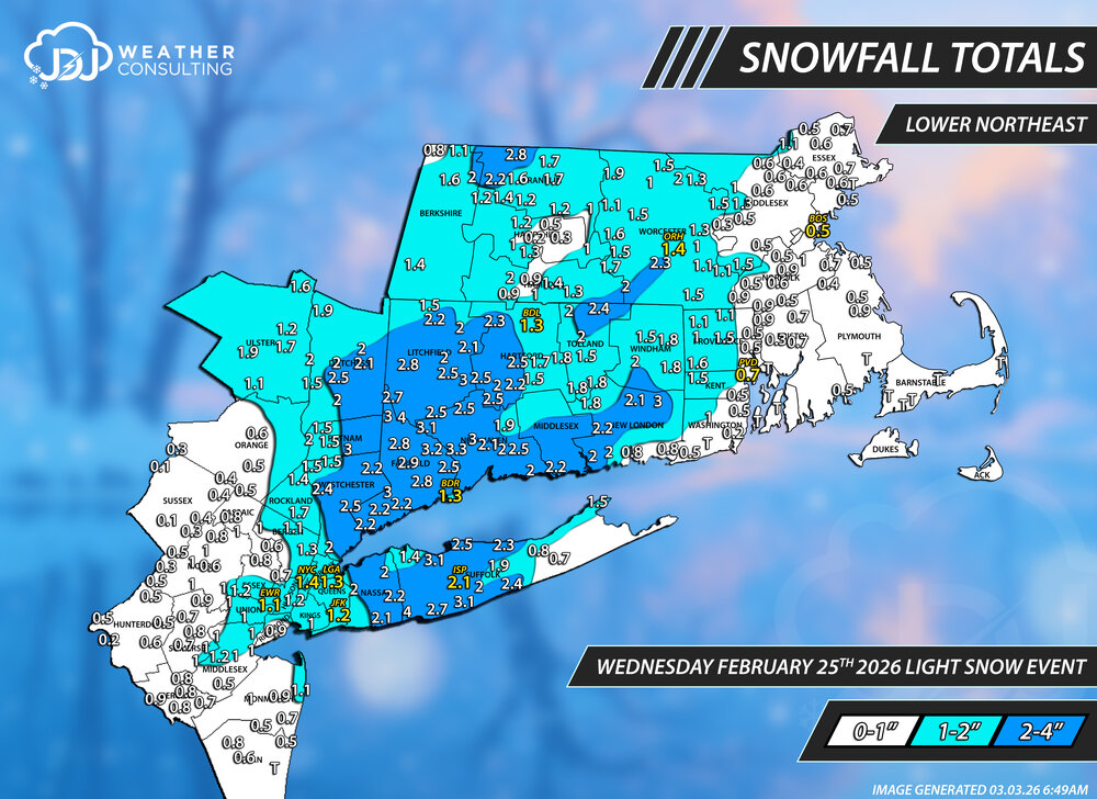
-

Pittsburgh/Western PA WINTER ‘25/‘26
CoraopolisWx replied to Burghblizz's topic in Upstate New York/Pennsylvania
IMHO, the biggest threat locally will be potential landslides over the next few weeks. Winter soil combined with above average rainfall and mild temps could be a problem. -
its nasty out.. should be a fun 4am drive
-
3.25" 25 degrees moderate steady snow.
-
Clipper Fires In Wednesday Feb 25 Disco/ Obs
The 4 Seasons replied to Damage In Tolland's topic in New England
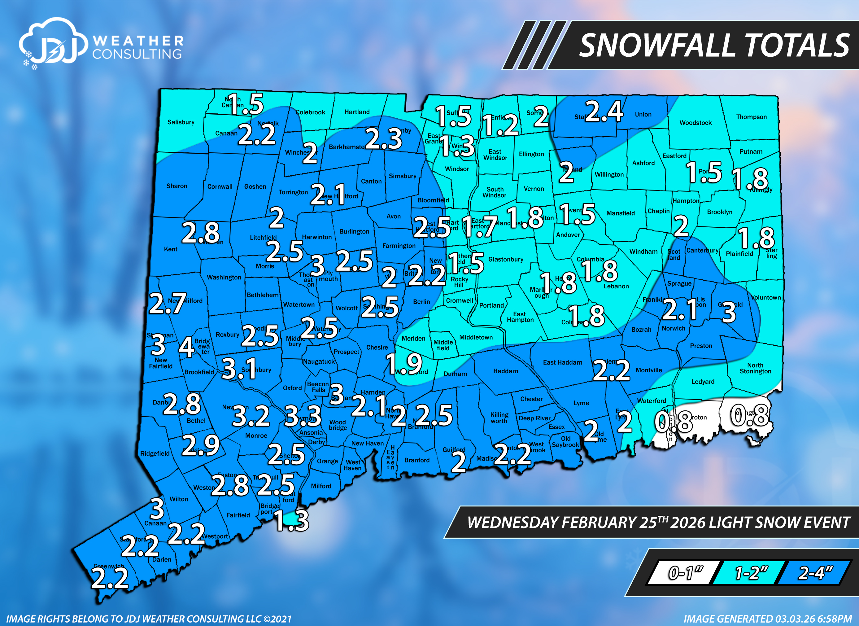
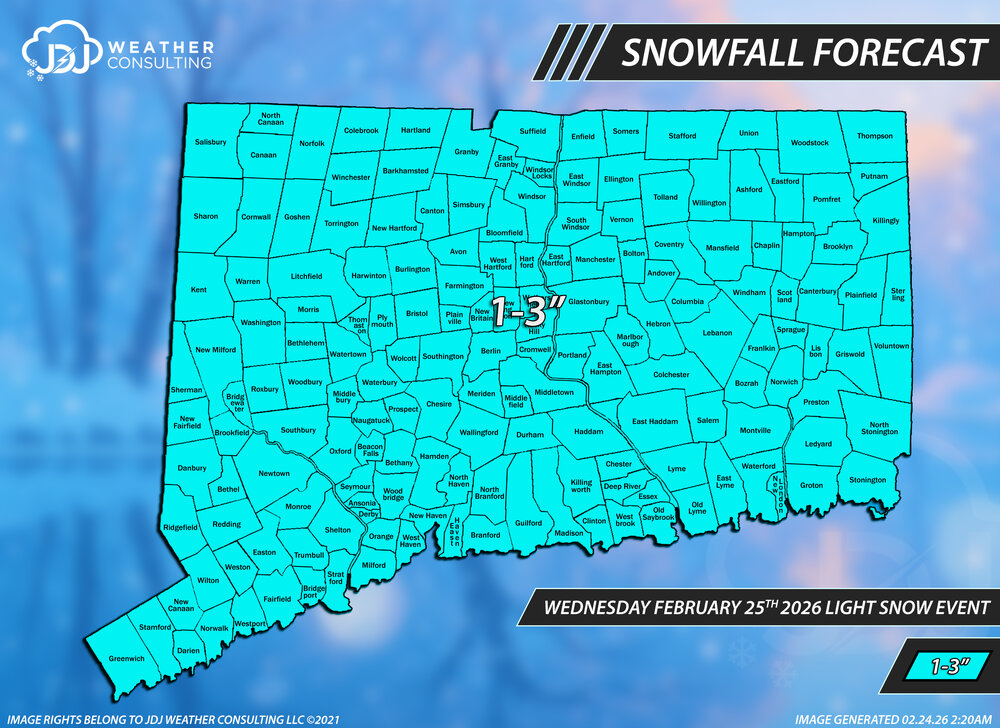
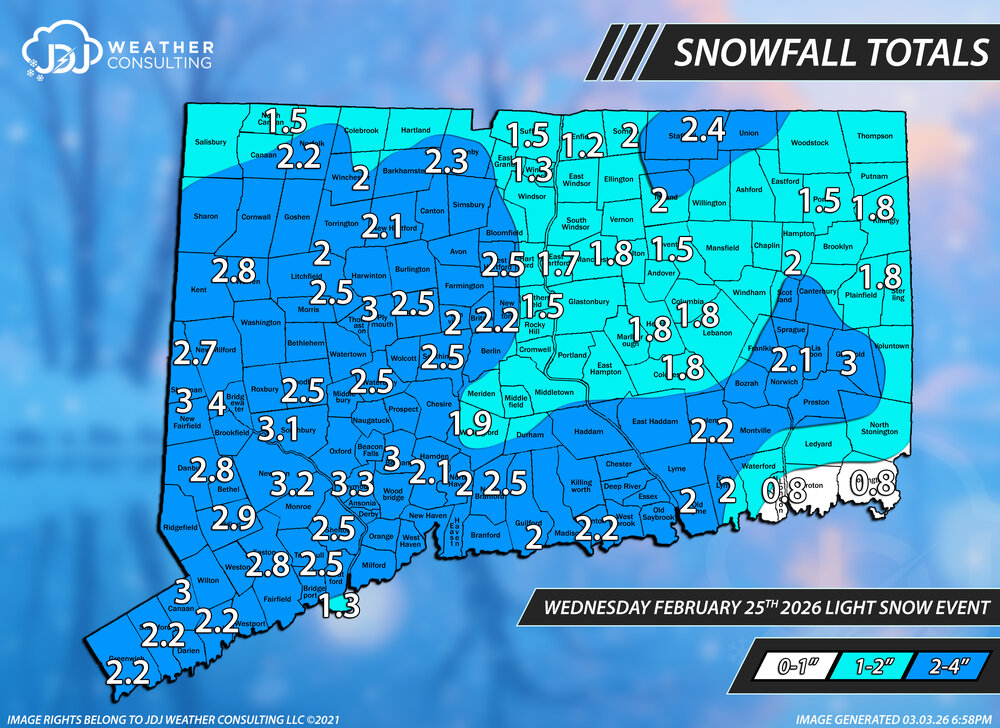
This storm is now up as the 12th 3"+ event of the season with snowfall maps, radar, sfc/upper air maps https://www.jdjweatherconsulting.com/feb-25-2026 We only did a CT map for this but 1-3" worked out nearly perfectly with just a few reports slightly over and a couple slightly under in far SE New London County. The ranges are changed to factor in the entire region. Grade A-
-
My sense is there’s kind of like a contest in some people There is none It was always going to warm up and then likely cool back down We’ll see what that entails on both ends of that, but there is no contest
-
It’s verified.
-
Hopefully it has a clue.
-
Ninas are pretty much death to your area in winter, which is in the downslope area of the higher terrain the to west. Ninos should be better with big coastal storms that aren't late developing/offshore. Maybe this coming winter will be more fruitful. In summer that same effect causes it to be generally dry (with prevailing westerly winds) relative to surrounding areas. A veritable desert. Frustrating for a weather enthusiast unless dryness is preferred.
-

Mountain West Discussion
mayjawintastawm replied to mayjawintastawm's topic in Central/Western States
Dang. Just a trace of rain here. Nothing measurable since sometime in late January. -
Euro Skynet with lots of snow mid-month.
-
Pick em up instantly. Too small to be out by themselves and no electric fence
-
The winter weather advisory for the area is seriously severely worded…lol. Says “tree damage and power outages are Likely.” And “travel could be nearly impossible.” I gotta say, I’ve never seen an advisory worded that severely before. Hyperbole?
-
Nice