All Activity
- Past hour
-
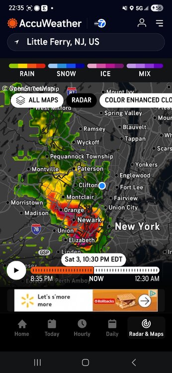
Going to call out - in case we are tracking these things now: the severe thunderstorm warning area seems off (looking at RadarScope) - we had no warning here. this seemed to not match radar: * This severe thunderstorm will be near... Mott Haven and Midtown Manhattan around 1040 PM EDT. Laguardia Airport and Jackson Heights around 1045 PM EDT. East Tremont around 1050 PM EDT. Co-op City around 1100 PM EDT. City Island around 1105 PM EDT.
-
Half inch on the nose here.
-
Hail! and frequent lightning on UWS.
-
Not good if you're looking for sustained warmth in the foreseeable future
-
Was visiting friends in Flemington earlier, had to take a pic.
-

E PA/NJ/DE Spring 2025 Obs/Discussion
JTA66 replied to PhiEaglesfan712's topic in Philadelphia Region
.35” I suck worse than the NAM -
-
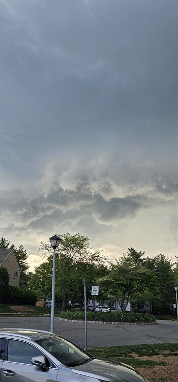
Absolute stunning light show to my south and west.. Radar looks very impressive.
-
Looks like .60 or so, still raining.
-
My numbers for the month of April 2025 Averaged high for the month was 69.1 degrees vs a normal of 66.2 degrees, a +2.9 degrees above average. The warmest temp recorded was 85.3 degrees on the 20th. Averaged low was 42.5 degrees vs a normal of 38.9 degrees, a +3.6 degrees above average. The coldest temp recorded was 24.7 degrees on the 10th. Overall averaged temp was 55.8 degrees vs a normal of 52.5 degrees, a +3.3 degrees above average. Total rainfall for the month was 2.30 inches vs a normal of 3.64 inches, a -1.34 below average. The wettest day was the 7th with 0.65 inches. There were 14 days with measurable, one day with a 'T', and 15 dry days. There was zero snowfall for the month vs a normal of 0.3 inches. The highest wind recorded was 42 mph. There were 13 days with winds above 25 mph. Several new records. A new record high on the 6th, and 4 new 'warm minimums' on the 5th, 6th, 7th and 22nd. Overall, a warm and semi-dry month.
-
Highs: EWR: 88 TEB: 87 LGA: 87 NYC: 85 New Brnswck: 85 PHL: 85 TTN: 83 ACY: 83 BLM: 83 ISP: 72 JFK: 71
-
0.09" here... My new grass is begging for more.
-

E PA/NJ/DE Spring 2025 Obs/Discussion
RedSky replied to PhiEaglesfan712's topic in Philadelphia Region
Eleven years old in Florida rained so hard the relative couldn't drive-that hard -

E PA/NJ/DE Spring 2025 Obs/Discussion
MGorse replied to PhiEaglesfan712's topic in Philadelphia Region
Still dry here! -
0.75”. Hoping that stuff to the south holds together.
-
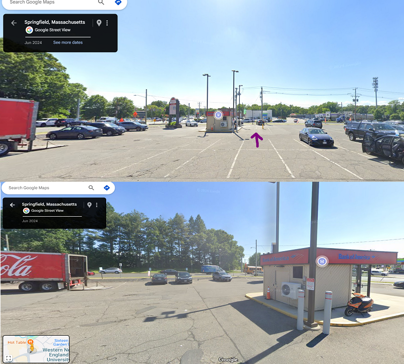
Here's the real thing which is better than what the video provides. I put an arrow in the spot I was in which points in the direction I'm facing. The bottom view is looking over to my left. So where those trees snapped was JUST out of my view. And actually...in the second pic if you see where those cars are parked, I was contemplating parking in those spots...I would have backed in and not be facing the trees but the circulation could have directly passed over my car...I also would have seen it coming from a farther distance because I would have had me head facing that direction. I could have gotten out of the car and film
-
It was too brief here to get that much (it's already over), but we did get a quick 0.28". Came down very heavily for a few minutes. Not bad ... at least it was just enough to give things a much-needed watering. I didn't think we would see anything today. It was a nice little storm.
-

E PA/NJ/DE Spring 2025 Obs/Discussion
Birds~69 replied to PhiEaglesfan712's topic in Philadelphia Region
Nailing the window making a bunch of racket.... -
A widespread heavy round of showers & storms made its way into the LSV now.
-
E PA/NJ/DE Spring 2025 Obs/Discussion
RedSky replied to PhiEaglesfan712's topic in Philadelphia Region
Could have showered outside and saved the planet oh well -
Might get close to a half inch out of this
-
E PA/NJ/DE Spring 2025 Obs/Discussion
JTA66 replied to PhiEaglesfan712's topic in Philadelphia Region
Same! Puking fatties here -
I'll have to get a flashlight and try to eyeball the gauge, but been pouring here for last 15 minutes.
-

-
E PA/NJ/DE Spring 2025 Obs/Discussion
Birds~69 replied to PhiEaglesfan712's topic in Philadelphia Region
Philly is getting shafted out of this deal. It's a Northwest thing. I'm under red and orange echoes but just to my SE pretty much nothing....


