All Activity
- Past hour
-
15.3" here Still snowing lightly
-
Tony Feen is a good name
-
Totally happy with 11" in Brick. Not bad considering we went above freezing with pure rain for a while but no significant melting. Temps dropping now. Will be solid ice pack by morning.
-
Seems like storm is just about done. 16" for the day.
-
Thou dost protest too much. How long have you and the NAM been seeing each other?
-

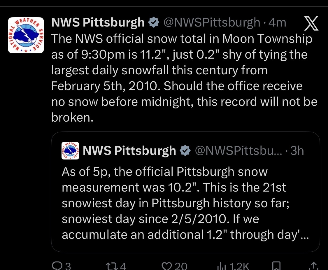
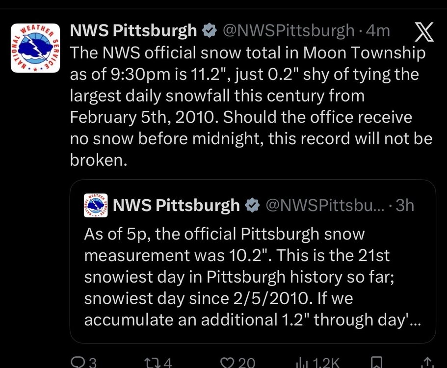
Pittsburgh/Western PA WINTER ‘25/‘26
CoraopolisWx replied to Burghblizz's topic in Upstate New York/Pennsylvania
Snow board measurements are usually more than in ground post storm measurements. -

January 24-26: Miracle or Mirage OBS Thread!
Snowciopathic Snow Bro replied to Jebman's topic in Mid Atlantic
Who knew that it would take a glacier to bust a drought? -
Here's the high pressure on that European run .
-
 Definitely drifting going on out there. Anywhere from about 12-12.5" Went 10-15" so well within that range. Maybe even tack on another inch or two. Headed to bed...curious to see what it compacts down to when I check around 5:30
 -

Southern Crippler - Get well soon Jimbo Storm Obs
NorthHillsWx replied to BooneWX's topic in Southeastern States
Roads are possibly the worst I’ve ever seen here. Sheet of ice on base and the grainy sleet caved to ZR at the end so really just a sheet of ice -

January 24-26: Miracle or Mirage OBS Thread!
MN Transplant replied to Jebman's topic in Mid Atlantic
Funny thing is that it was kind of a calculated number. At no point did I ever have more than ~7.7” on the ground. A lot of compaction with the weight of the sleet on top. But I also couldn’t find any place that would legitimately give me more than 3.5” of sleet. So, yeah, a 2:1 ratio on the sleet. -
 Very similar to what I have. 7" and 7.5" were my two measurements with a 14" depth at 8:30. Been full on sleet since 9pm.
 -
Seems accumulations have been as high or higher in Central Westchester/Rockland than places like I84, surprising but shows how random these things are with banding/snow growth.
-
The warm nose in question...

-
Probably won’t happen as depicted of course :(.
-
Its been terrible since about 2p. Its been all snow too, no mixing
-

Pittsburgh/Western PA WINTER ‘25/‘26
wstaude replied to Burghblizz's topic in Upstate New York/Pennsylvania
with all of the 11-12" reports in AGC I doubted myself, but I've measured several spots and nothing over 9.5". -
Wow, with that kind high/low pressure gradient would be an all time great wind storm. Maybe like Feb 1978.
-
 Snow has been coming down hard for the past 6 hours. Hard to tell with the drifting but in Arlington MA I'd say we have 15-17" so far. If the storm continues to print in the remaining 4-5 hours of heavier snow, and if Monday pans out, wouldn't be surprised to see 24-30"
 -
it's been a LONG time since we had a precip producer like this.
-
Pittsburgh/Western PA WINTER ‘25/‘26
CoraopolisWx replied to Burghblizz's topic in Upstate New York/Pennsylvania
-
I now have an absolute glacier, thinking about naming it. All the best glaciers have names.
-
 still snow here. maybe an occasional pellet
 -
DC got literally 100% more precip than the 3K NAM said it would get in a run quite literally the day the storm started, lol It had us dry slotting and the main vector of precip well to our north throughout much of today. If anyone’s takeaway from this storm is that we should pay more attention to the NAM because the non-crappy models got the changeover to sleet wrong by 2-3 hours, well….lol
-
 Dumping in W Hartford right now