All Activity
- Past hour
-
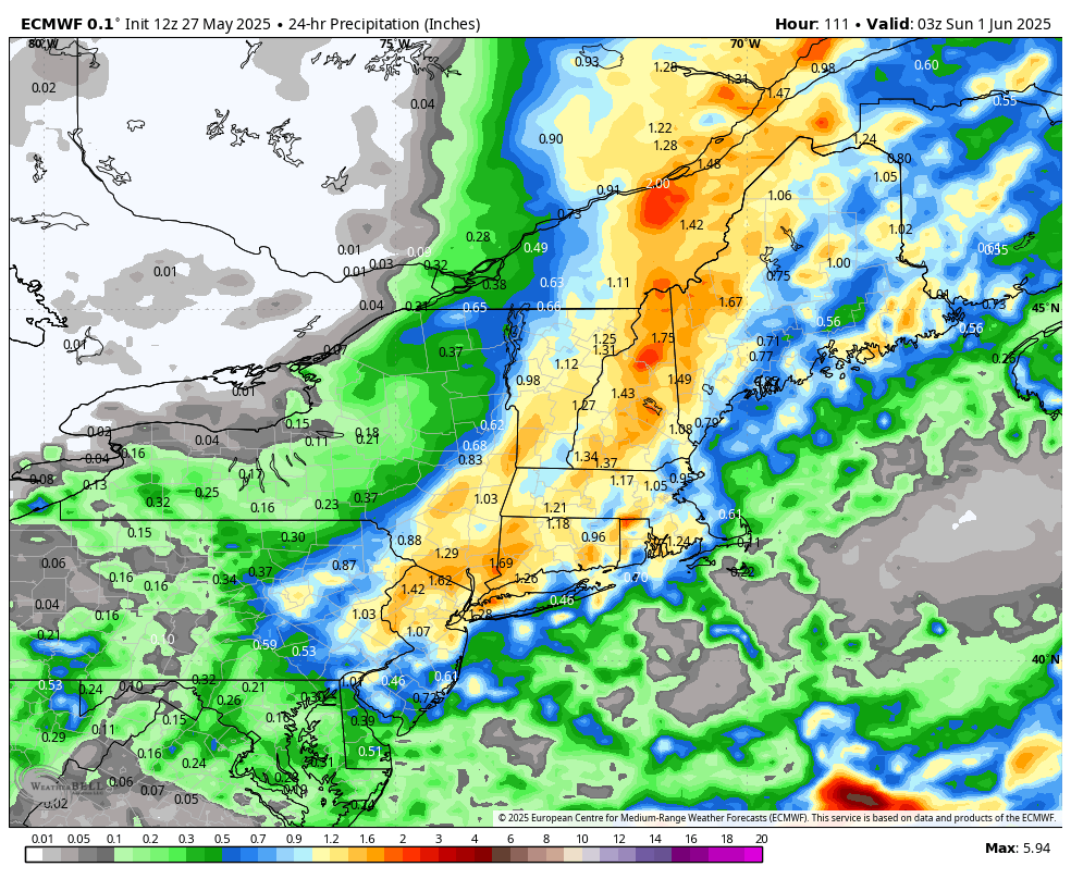
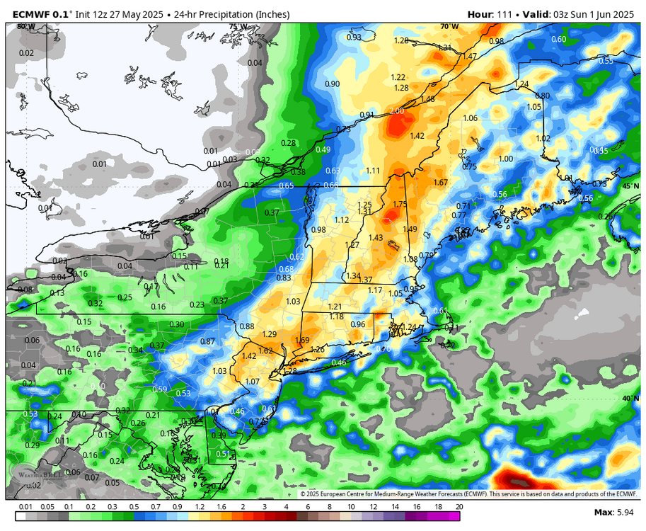
Saturday system looks to be trending a bit towards a cutter/inland track. Probably a bunch of p-type issues pretty far inland with those tracks. 6z Sat to 6z Sun.

-
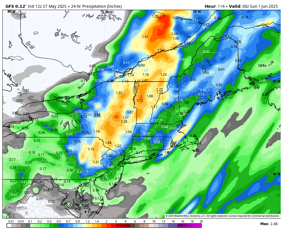
yeah sell the GFS with that thing... that's spurious until it gets anything resembling support - which is far as I've found there is none.
-
Not really ... 570+ thickness building into the region after D7 ...? though I'm not sure what, nor when, people are whining about in this recreational complaining outlet. But 588 height to Concord NH with 850s > 16C is is not a disaster for warmth and humidity
-
I've never known someone to be sssoooo fascinated with toilet paper lol
-
Did you notice the effective date of that drought monitor map is 5/1?
-
Dangit I thought I had most of the day to finish up yard work before the rain arrives. So much for that! Light rain and 63
-
https://x.com/contentwxguy/status/1927403235452539027?s=46&t=dhcbvkjmRcyBVQtDxJ3lRg
-
78 and humid feeling. Lots of puffy clouds under higher level haze looking clouds. I can't remember the names anymore lol
-
Stock up on TP. Summer sizzler of HHH about to settle in
-
So many 99 degree days looks really weird. There were as many 99 degree days (19) as all the 100-104 degree days combined (also 19) !!
-
That’s a Ricky look.
-
Euro heater mid week next week.
-
CMC also a disaster for the HHH crew.. Maybe day 10 but looks like a front comes through after that
-
Especially if the late week threat materializes too.
-
Oy...they gonna have to cancel O's games today and tomorrow? Man we had rain-out chaos when we played the Cards last year, lol
-
lets see if the Euro still has it at 12z the GFS is a disaster for the heat and dews
-
Page Hits!!
-

Central PA Spring 2025
Itstrainingtime replied to canderson's topic in Upstate New York/Pennsylvania
Warm/hot weather lovers...it's coming: (from MU) Fortunately, the large-scale weather pattern will do a "complete 180" during the first week of June. The high-latitude blocking that developed over Greenland during the middle of May will finally vanish in the next 7 days. As a result, the persistent trough, or dip in the Jet Stream, over the eastern United States and pattern of slow-moving, upper-level lows will be replaced by faster, zonal (west-to-east) flow and even a subtle northward bulge in the Jet Stream. A subsequent warming trend will take place from Monday through at least the middle of next week, and it could be a big one. The week will probably kick off on a sunny but rather cool note with high temperatures in the mid 70s, but southwesterly flow on the backside of a high pressure system over the western Atlantic should return by the middle of the week and boost highs back into the 80s by Tuesday. While uncertain, the mercury may even make a run at the 90-degree mark at least once or twice between next Wednesday and Saturday. In addition, the large-scale subsidence, or sinking motion, associated with the high pressure system should promote much drier/brighter conditions and spell an end to our soggy pattern. However, dewpoints could climb into the uncomfortable 60s or perhaps even low 70s later in the week, so steamy/sultry conditions may replace unseasonably chilly ones within the span of just 3-5 days. -
Speaking of JFK, I remember when it hit 99 under fully overcast skies with a W or NW wind. I don’t remember what year that was but it was in the early 2010’s when I still lived in Queens, it felt so weird.
-
This seems reasonable.
-

E PA/NJ/DE Spring 2025 Obs/Discussion
RedSky replied to PhiEaglesfan712's topic in Philadelphia Region
Squeezed out one 24 hour period without precipitation Radar looks great for rain coming in ahead of schedule, possibly overnight? This last month was like February 2014 in May. -
Got quite warm today. Currently 75 degrees in Tamaqua, and up here in normally colder Hazleton where I'm delivering today.
-
That is a thought I had too. But something is going on, I mean we can even extend what seems to be poor skill back 3-4 years now, especially in winter. There have been some extremely large jumps within guidance inside of 72 hours and it seems just about every major model has had its share of failures. Part of me wonders if its just related to how complex the weather patterns have been or if its more human related. There is just so much garbage thrown around on social media for storm potentials several days out (sometimes even 10+) and there is so much focus on just one or two graphics, and forecasts start getting chucked out 4 days in advance. There is too much with taking a model at face value and very little critical thinking or skill applied. Its just take the model which shows what the user wants and then try to spin it into a forecast. Then when the forecast doesn't pan out, the models get blamed. At the TriState Weather Conference in October, a person asked a question relating why it seems like models were doing worse. I believe it was Dr. Tuell who responded, but he essentially said one problem is there is lack of responsibility taken and models are essentially used as a crutch as to why a forecast is wrong. I wish his answer was recorded, I thought it was a great statement.
- Today
-
Needed that in January
-
Nice--That would effectively end the drought, right?