All Activity
- Past hour
-
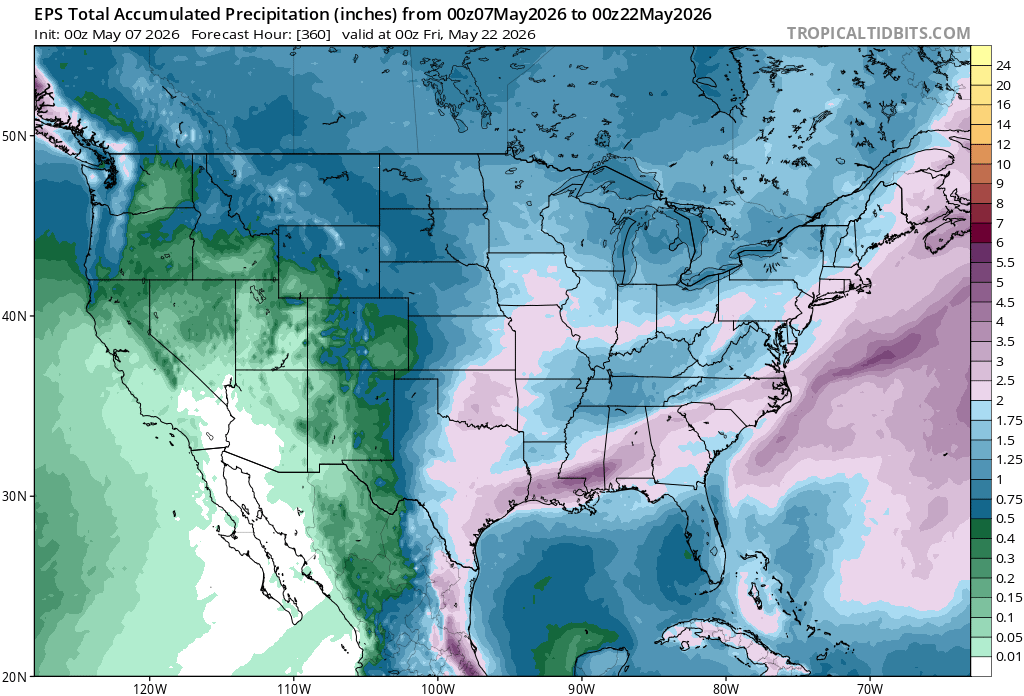
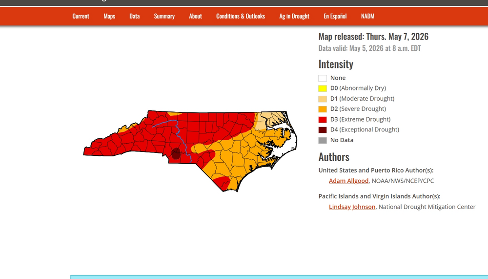
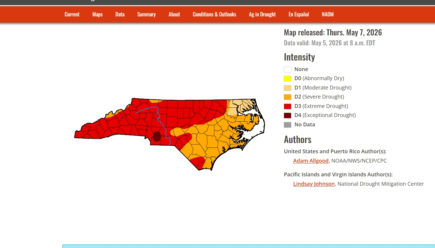
Keep in mind that the heavy rains covering much of the SE US since yesterday are of course not taken into account since these weekly maps are based on data being submitted no later than 8AM two days ago.
-
53 / 45 clouds splitting the area angled SW to NE - should clear out and make way for a nice albeit cooler next two days. 0.40 in the bucket. Clouds / showers Saturday another 0.25 - 0.50 rain and into Mothers Day and then on / off rain in between days next week. Overall cooler than normal through mid month before a moderation to a more persistent warmer pattern between the 17 - and beyond.
-

-
Not much change.
-
1.5-2" of rain for half the month isn't bad.. it's about average. pre-El Nino May's are nothing significant in the MA
-
Let's do it
-
Looking at official rainfall totals, a large portion of AL, TN, N and C GA, NW SC to CAE, and NC including CLT received ample to very heavy (flooding) rainfall since yesterday! Fantastic news regarding the drought and kudos to the Euro Weeklies to being on top of this potential for several weeks.——————This is just from FFC:MOST LOCATIONS HAVE SEE ANYWHERE FROM 0.5" TO 1.5" OF PRECIP WITH SOME ISOLATED LOCATIONS SEEING UPWARDS OF 2" TO 4". 1 LOCATION HAS SEEN 5.29" (CSG).
-
I really did! Lol. Last 18 mos in my area, its either a drought, or a flood. Up to 4.75" of rain now, more than 4 of it in 2 hours.
-
Dropped my scrip to Aguacero and switched to WeatherFront. Really liking WF and it’s products .
-

2026 Spring/Summer Mountain Thread
franklin NCwx replied to Buckethead's topic in Southeastern States
Closing in on 3 inches as its starting to wind down here -
It hit a trailer park unfortunately. Likely EF3 damage outside of the park .
-
I decided against it as trees made it nearly impossible to navigate and the back roads all had a northbound component with little east or west options. Besides, the storm was HP (that has not stopped me before) but in the location it tracked there was no way of even getting a good view without putting myself in a very bad position. I’m also glad I did not chase because I-55 had to be shutdown in both directions as trees were blocking the road. This is also why I am so hesitant about chasing south of I-20. You kinda of make your decision with little to no other option of getting out once you are down there. To help me make go vs no go decisions, I use Google Maps and the street view to help get a better understanding of the road network or even possible intersections before chasing in my chase target areas. I tend to find it more successful when I do study my chase targets as it allows me to have a better understanding of what I might come across instead of going in blind. Even when I am thinking about going into the Delta, I like to have a rough idea of what roads will lead back to a major highway or interstate for my commute back or in case of an escape route. I also tend to find places where I can pull over at where I can get back on the road safely and with little trouble. I may miss more opportunities to chase when doing this, like last night, but I also know I much rather be comfortable and safe than unsure and feeling lost. My end goal of chasing is to photograph and document storms. I am not here to be the next Reed or anything like that. This is just a hobby for me.
-
1.25” here .
-
The thing is, the warmer pre-strong/super el nino summers in the Eastern US (1991 and 2015) were preceded by borderline warm neutral/weak el nino winters. We did not have that this year, like in 1972, 1982, 1986, 1997, 2009, and 2023. All of those years had cooler summers.
-
I thought you said it was never going to rain again. Lol.
-
Even when we didn't have NW flow it was dry as a mofo and basically at 90 degrees... We need a stall front to just sit across the area and produce rainfall.
-

2026-2027 Strong/Super El Nino
PhiEaglesfan712 replied to Stormchaserchuck1's topic in Weather Forecasting and Discussion
91-92 would have probably had a big global temperature jump if not for Pinatubo. It was the 3rd robust el nino in 10 years, and coming off the heels of a temperature jump from the 86-88 el nino. But my guess is that if Pinatubo never happens, 97-98 still has a temperature jump, but not as drastic. 97-98 not only had the super el nino, but the exiting of a cooling period from a major volcano to enhance its temperature jump. -

Central PA Spring 2026 Discussion/Obs Thread
Mount Joy Snowman replied to Voyager's topic in Upstate New York/Pennsylvania
This probably amuses me more than it should.......low of 46 with .46" of rain. It's gonna be a good day ha. -
Welcome to the west side of the state
-
Still not looking great on eps and gets
-
Still too much nw flow
-
Started to rain around 12:30 last night so I checked the radar. Huge red blob in southern Fairfax/PW counties. Northwestern tip of it touching I66 in western Fairfax. I only got light rain and one distant rumble of thunder. It looked like the blob might hit DCA but checking this morning, they just got a few hundredths too.
-
It was the 15th warmest April at MSN and we were able to snag the wettest April on record with 7.26” of precip. Only a T of snow
-
Beautiful Mothership man!! I'd run a Waffle House out of coffee picking Trey's brain lol. Happy you didn't get totally burned. Great pics!
-
The following is very interesting as regards the controversial topic of potential significant deep ocean heating from sources independent of AGW such as deep ocean seismic activity: Apr 28, 2026 An anomaly in global sea level rise is explained by deep ocean heating by David Appell, Phys.org Scientists found that up until 2016 that the global mean sea level (GMSL) "budget," accounting for all the energy flows that create sea level rise, was "closed," but since then it has developed a hole in it. The budget is no longer closed, at least according to ocean heat data, down to 2,000 meters. Where was the missing cause for the latest sea level rise? Now a new examination of sea level in the global ocean since 2016 has closed the GMSL budget and brought the sea level books back into order. The new researchappears in the journal Earth's Future. The paper is important for showing that deep ocean heating can no longer be ignored when considering sea level rise and its acceleration. Deep ocean heat's growing role In particular, the researchers, with lead author Anny Cazenave, an emeritus scientist at the Laboratory of Space Geophysical and Oceanographic Studies (LEGOS) at Toulouse, France, found that accounting for sea level rise from expansion due to added heat in the deep ocean, below 2,000 meters, allowed the GMSL budget to be "almost closed" since 2016. "The next step," they write, "will be to determine whether the recent deep ocean change is due to internal climate variability, forced anthropogenic response or a combination of both." https://phys.org/news/2026-04-anomaly-global-sea-deep-ocean.html ——————————————— @donsutherland1, @chubbsand others, your thoughts? Does this imply that deep ocean seismic activity MAY actually be an independent nontrivial source of ocean warming after all? Perhaps this may help explain the pockets of extreme ocean warming such as has been the case in the W PAC? Keep in mind that David Appell is not at all an AGW skeptic.


.thumb.jpg.049f4a7f726ada07e8cd30bd17e713cb.jpg)