All Activity
- Past hour
-

E PA/NJ/DE Winter 2025-26 Obs/Discussion
Newman replied to LVblizzard's topic in Philadelphia Region
Details to be sorted out later, the good news is it's looking highly likely that someone along the East Coast will get a storm this coming weekend. Models will waffle north and south all week. But tbh, I'm feeling really confident for areas I-80 south. These things almost always come north. -

January 2026 regional war/obs/disco thread
Go Kart Mozart replied to Baroclinic Zone's topic in New England
They will in a few days. This is an event that is tailor made for AI. -
I am going to look at the last 10 years of results and congratulate the fine people of VA Beach on another snow storm. Weenie me.
-

Rise of the Machines: January 18-19 Winter Storm Obs Thread
CCHurricane replied to WxWatcher007's topic in New England
4.0” OTG in Barnstable, storm even likely closer to 4.5”. Can see a distinct layer of melt at bottom of snow. -

January 2026 regional war/obs/disco thread
Sey-Mour Snow replied to Baroclinic Zone's topic in New England
The Canadian Parallel is a KU for New England the weekend, I've been looking at it, no idea how it scores, it was one of the first models to catch on to yesterday's potential, that's about all I know about it.. It's experimental, but I read it's taking over for the CMC this year .. -

January 2026 Medium/Long Range Discussion
NorthArlington101 replied to snowfan's topic in Mid Atlantic
FWIW - the new Canadian (I think it replaces the old in the spring) is light snow -> sleet -> little bit of FRZA. So it’s amped and totally different than the about-to-be-replaced version -
The MSL pressure field actually shifted north in the TVA on 6z vs 0z eps. Mostly noise, but the shift was noticeable.
-

Rise of the Machines: January 18-19 Winter Storm Obs Thread
alex replied to WxWatcher007's topic in New England
A surprise couple of inches here, stake up to 13” -
They such bullcrap. They should be over 10.
-
The 0z and 6z Euro Ens essentially look the same wrt precip/snowfall at 6z on Sunday, outside of run to run noise. There is no 'trend'. I am going to trust the Euro more overall for this potential event given how crappy the GFS has performed recently. I will lump the AI models in with the GFS/GEFS based on their performance with our recent (mostly Non) event.
-
We are going to have Phase 8 MJO Slightly negative NAO Deeply negative AO Positive PNA
-

Rise of the Machines: January 18-19 Winter Storm Obs Thread
Ginx snewx replied to WxWatcher007's topic in New England
So pretty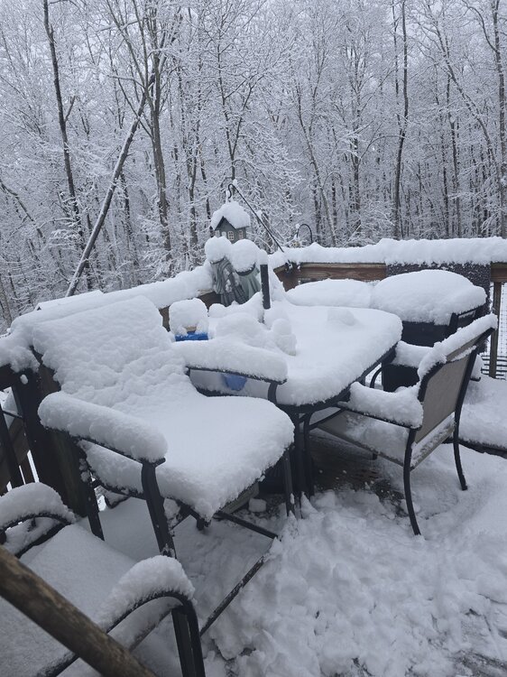
-
From NWS GSP: “As for the even further out potential system for the weekend, model guidance keeps the high pressure parked over the central part of the country and eventually makes its way into the area. There is much discrepancy and uncertainty if the frontal boundary is able to make anything of the weak moisture return. Friday and Saturday could see a mix of precip but again, its too far out. There is a possibility for a wintry mix as the transition zone and colder air move in. A few of the individual models show a signal for snow, but there is still much uncertainty. Any shift north or south of the potential boundary could be the difference in rain, snow, or nothing at all. And as this location has seen again and again, it`s all a matter of whether or not the cold air can even make it in time. Will continue to monitor as this system is going to change this far out.” So many important caveats in that discussion… .
-
I'm too young to be looking at porn...

-
Closeup


-

Rise of the Machines: January 18-19 Winter Storm Obs Thread
Snowedin replied to WxWatcher007's topic in New England
That’s what I told my last ex -
You're absolutely right, but can we go ahead and pin it too? This week is must see TV! One step short of Kamchatka. I mean could you imagine our board in the week leading up to Kamchatka?!?! . So lets live a little. Its the only weather we got man. And the board is about to be as hyped as it has ever been. Let's pin the thread. Cuz I'm tired of searching for it and its only Monday.
-
We are going to have Phase 8 MJO Slightly negative NAO Deeply negative AO Positive PNA
-

Rise of the Machines: January 18-19 Winter Storm Obs Thread
WxWatcher007 replied to WxWatcher007's topic in New England
Well, we made a valiant effort to comeback, and we finished at 2.7” here at WXW1. A truly gorgeous scene around town. -
I don't have snowfall maps, but here is the total qpf for the event.
-
That is such a BS measurement. Almost all the other places in the boroughs measured in between 1.5 to 3 inches today, a combination of both the snow from the morning and from the evening. If they measured properly, they would have had more than 1 inch. Their measurement problems have become so exacerbated since the start of the decade. They’ve consistently been, on average like 1-2” less than nearby areas in every storm, and it adds up. They should either measure somewhere else in the park or maybe they should measure in Riverside park on the west side where it’s more expansive. We’ve seen this time and again now.
-
Beautiful
-

Rise of the Machines: January 18-19 Winter Storm Obs Thread
HoarfrostHubb replied to WxWatcher007's topic in New England
So it’s Monday… -
Bottomed out at 15.5 degrees around 3 am, then once again temp started to rise and managed to pull off a non-diurnal temp for what seems like the 10th to 12th time since Christmas, crazy. Currently 21.4/13.0 at 8 am with SW 8 gutsing 22 mph winds.
-
Rise of the Machines: January 18-19 Winter Storm Obs Thread
HoarfrostHubb replied to WxWatcher007's topic in New England
4.0” here in Hubbentucky. I’m sure 4.5” in Templeton


