All Activity
- Past hour
-
While the temps may be trending warmer, the winters have also been trending snowier and stormier for you all who are along/north of I-80. IMO, that's a good trade off.
-

December 2025 Short/Medium Range Forecast Thread
Daniel Boone replied to John1122's topic in Tennessee Valley
Yep. It was a frustrating Month. Overall cold but precip almost all fell in the warmups. High of Zero on Christmas for coldest on Record. Not a flake of Snow ! -
Same here in Garwood NJ, Central Union County
-
If pattern changes are almost built in rushed in guidance then why not develop a system that does not do that? Over last couple winters we’ve seen gigantic failure anywhere from 36 hours to 15 days out. Very few if any positive such surprises .
-

E PA/NJ/DE Autumn 2025 Obs/Discussion
RedSky replied to PhiEaglesfan712's topic in Philadelphia Region
Alaska November seen the sun like one day -
Yes. Since 2020, Pittsburgh has had 7 such days while New York City has had 6. Temperatures have not warmed so sharply and abruptly that such storms are precluded. I suspect that this winter will see at least one such day in both cities.
-

Fall 2025 Medium/Long Range Discussion
Powerball replied to Chicago Storm's topic in Lakes/Ohio Valley
I'm not sure it's possible to get hard data on it, but I know @michsnowfreak has expressed the same feeling on multiple occasions. -

Fall 2025 Medium/Long Range Discussion
A-L-E-K replied to Chicago Storm's topic in Lakes/Ohio Valley
it feels like that but i'd like to see some data and i'm too lazy/not interested enough to look myself -
Today is tracking to be maybe my coldest daytime high of the season so far, sitting at 47.3
-
Hmmm. Timely article I just read adds another data point...... https://www.cnn.com/2025/11/19/weather/polar-vortex-cold-snowy-december-stratosphere
-
I am an outstanding forecaster as the same areas continue to get drowned by heavy rain and Austin remains drier than a proverbial popcorn fart. That Curl Pattern always leaves Austin out to dry. At this time I expect approximately one sixteenth of an inch as the front goes by eventually. Farther west torrential rain continues, provoking more flooding.
-

November 2025 general discussions and probable topic derailings ...
Kitz Craver replied to Typhoon Tip's topic in New England
It would be really nice to avoid the default holiday screamer this season, we can hope. -
 Sometimes it’s hard to resist the temptation and You can’t help yourself .. from falling….
 -

November 2025 general discussions and probable topic derailings ...
IrishRob17 replied to Typhoon Tip's topic in New England
I think you threw one of those lyrics out there last week too and I waited for one of the locals to respond but I believed it was crickets on that so I went all in this time...I like living on the edge... -
Frost was everywhere this morning here.
-
 the PV closer to us has been perturbed already. seems like this should couple pretty well
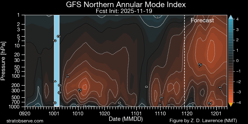
-

November 2025 general discussions and probable topic derailings ...
weatherwiz replied to Typhoon Tip's topic in New England
even mesos are a mess for us, yes but I am looking at more of the region as a whole (including just to our south. I would have to think any north guidance with the heavier axis is wrong but we do get some increasing diffluence aloft late with PVA so we may see showers blossom (just not heavy rain...maybe coast gets heavier rain). -
Only the GFS has soaking rain. It’s not hard at all. A shower or very light rain and call it a wrap
-
 Yeah. Night and day on the GFS and Euro.
 -
I actually don’t think that’s coming this year . I think it holds off until January when winter more or less ends . Like mid or maybe latter Jan.
-
I knew someone would kick into the verse
-
Could it a cold , dry 1989 type Dec.. could it snow a bit? There’s something happening here.. what it is Wolf ain't exactly clear .
- Today
-

November 2025 general discussions and probable topic derailings ...
Lava Rock replied to Typhoon Tip's topic in New England
Aliens -
November 2025 general discussions and probable topic derailings ...
weatherwiz replied to Typhoon Tip's topic in New England
What an absolutely colossal joke guidance is with tomorrow night. Who event wants to forecast precipitation events 4-5 days out? It's been absolutely terrible. I can only wonder how many storms we'll see on guidance 4-5 days out and the snow maps of 8...10...12+ inches start flying out only for significant reductions inside of 48 hours. Or who knows...maybe we'll get some in the other direction where it looks like crap and then we're forecasting 6-10" all of a sudden -
Fall 2025 Medium/Long Range Discussion
Powerball replied to Chicago Storm's topic in Lakes/Ohio Valley
Clippers have to be an endangered species at this point, but it's been that way for a while. I remember them being quite common in the 90s through mid-2000s.