All Activity
- Past hour
-
30th - the 4th or so still looks like -NAO frumunda' cheese though. Ooph.
-

2026-2027 El Nino
PhiEaglesfan712 replied to Stormchaserchuck1's topic in Weather Forecasting and Discussion
15-16 actually peaked at 1.97 in August: 2015 8 0.99 1.43 1.97 2015 9 1.04 1.48 1.80 2015 10 1.04 1.51 1.91 -
What a great run of wx in the face of "weeks of crap". Winner day after day
-

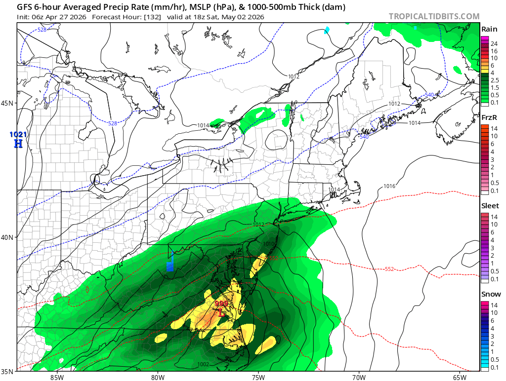
Potential Sever Weather Outbreak 4/27/2026
pen_artist replied to pen_artist's topic in Lakes/Ohio Valley
I feel like if there is really any chance at svr in NIL it would be late evening. 10 and 11z (haven't look back more) hint at at least thunderstoms with some rotation moving through the 9 PM -12 AM timeframe. -
55 vs 60. Big deal. I mean overall pattern.
-
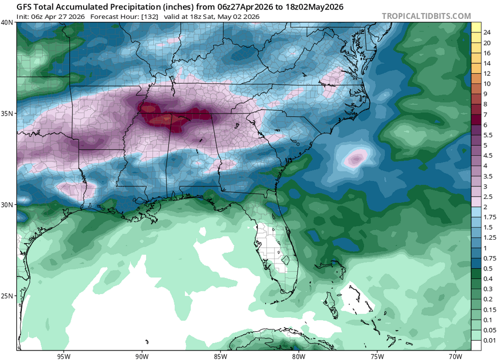
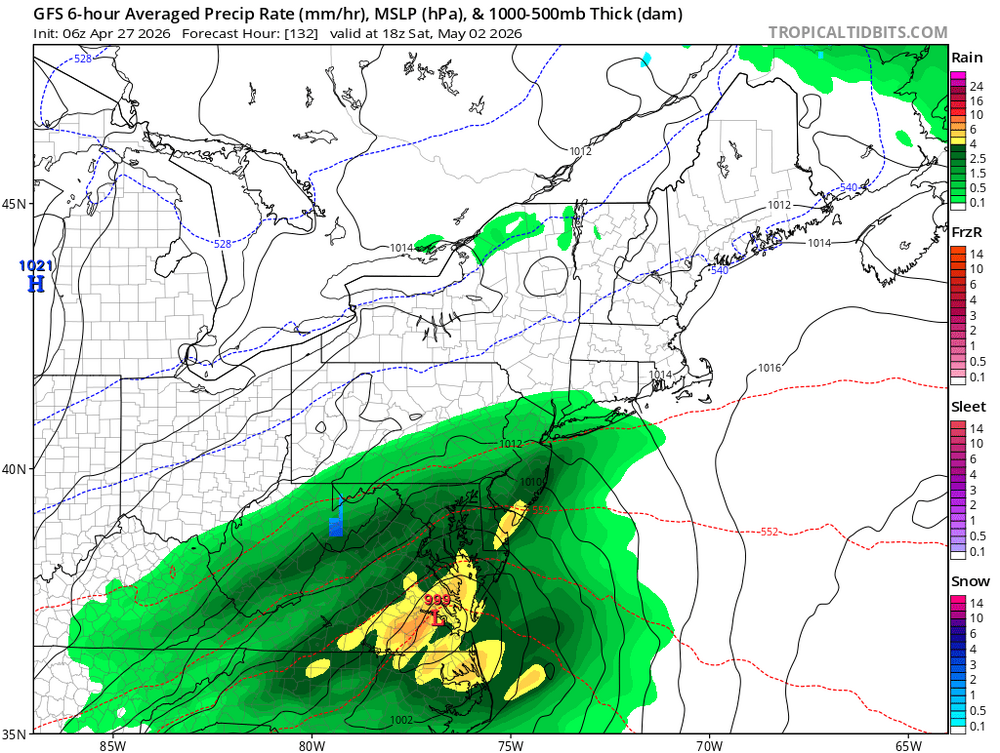
Latest GFS showing lots of precip the ATL area the next week. One can dream. I'd be happy with a quarter of what it's showing at this point.
-
Chilly this morning. Overnight low of 36.
- 915 replies
-
- 1
-

-
- april showers bring may..
- rain
- (and 2 more)
-
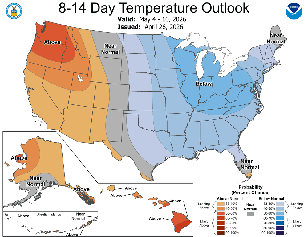
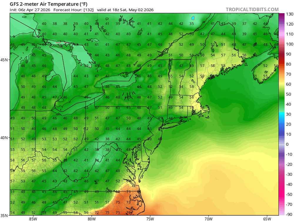
Unfortunately, the prospects for any sustained temperatures above the seasonal average is quite low as we move into the month of May and we may even have to wait fairly deep into May to flip the script. Unseasonably strong late season blocking continues to be a dominant mode within the Arctic domain and Greenland resulting in troughniess and below average heights dominating from the northern Inter-mountain West region across the northern Plains, upper-Midwest, and Northeast. There are some hints on the GFS/Euro we could see this pattern breakdown a bit moving towards mid-May, however, it is very possible that is a bit too optimistic and it is just the weighting of climo towards the end of the run making it appear the pattern will breakdown. Hopefully towards the back end of the month we can introduce some heat, humidity, and severe weather chances. While May is the beginning of severe weather season, that doesn't mean we get flooded with threats right away. Just like how June 1 is the official beginning to the Atlantic hurricane season...we aren't flooded with hurricanes on June 2. Patience, patience, patience.
-

2026-2027 El Nino
snowman19 replied to Stormchaserchuck1's topic in Weather Forecasting and Discussion
Yea, the only year with an OHC this warm, this early is 1997. And we have yet another WWB waiting in the wings for May courtesy of the MJO propagation back to the PAC and a protected parade of TC’s…. -
Vying for the diurnal yearly record on this one. Decimals above 32 for a low, now 51 just 2 hrs later is exception. When driven purely by sun in still unmixed air that's exceptional. Normally I'd think machine guidance would be cool biased on a spring day with sun this tall and quite hot (August 15 equiv). But I was a bit surprised to see MET and MAV 68 to 70 around the BDL-FIT-ASH horn ...thinking those products would be 64 happy -NAO blue ballies. The lowest 200 feet to the ground is definitely going into a super adiabatic state, with lased ground-air conduction thermal exchange going on so despite the MOS above, 73 ping highs? Rarely get a 40 F, purely diurnal driven spread this closed to sea level yet these metrics make that look plausible. There's also likely to be a sea breeze boundary/cold wedge wobbling toward and probably somewhat beyond 495 by late afternoon. All this repeats tomorrow.
-
E MA up to its normal antics . N ATL FTL
-

Central PA Spring 2026 Discussion/Obs Thread
Mount Joy Snowman replied to Voyager's topic in Upstate New York/Pennsylvania
Low of 40 with some heavy dew, not to be confused as .01-.02" of rain. Talking to all you Cocorahs observers out there haha. -
Just make it warmer
-
Let’s just hope this means we can keep the heat off while the AC isn’t being used.
-
Ugh, we’re doing a weekend trip to Charlottesville, lovely.
-
Nice couple days shaping up-was down to 36 here this am with frost on the roof
-
GFS says if you thought this past weekend was blah, we’re going to crank up next weekend on the shitty weather scale.
-
Crazy stuff
- Today
-
Already 52.. off to the torches .
-

Central PA Spring 2026 Discussion/Obs Thread
Superstorm replied to Voyager's topic in Upstate New York/Pennsylvania
37.6 F in Lancaster for the low. . -
Central PA Spring 2026 Discussion/Obs Thread
Superstorm replied to Voyager's topic in Upstate New York/Pennsylvania
Sweltering! . -
35.4° this morn Should make a run at 70°.
-

Central PA Spring 2026 Discussion/Obs Thread
canderson replied to Voyager's topic in Upstate New York/Pennsylvania
Low of 78 it looks like in Austin. About to head back to home. Wedding yesterday was outdoors - since yesterday it 92 and a 78 dew point they brought out massive misting fans. It helped somewhat. lol -

Central PA Spring 2026 Discussion/Obs Thread
mahantango#1 replied to Voyager's topic in Upstate New York/Pennsylvania
-
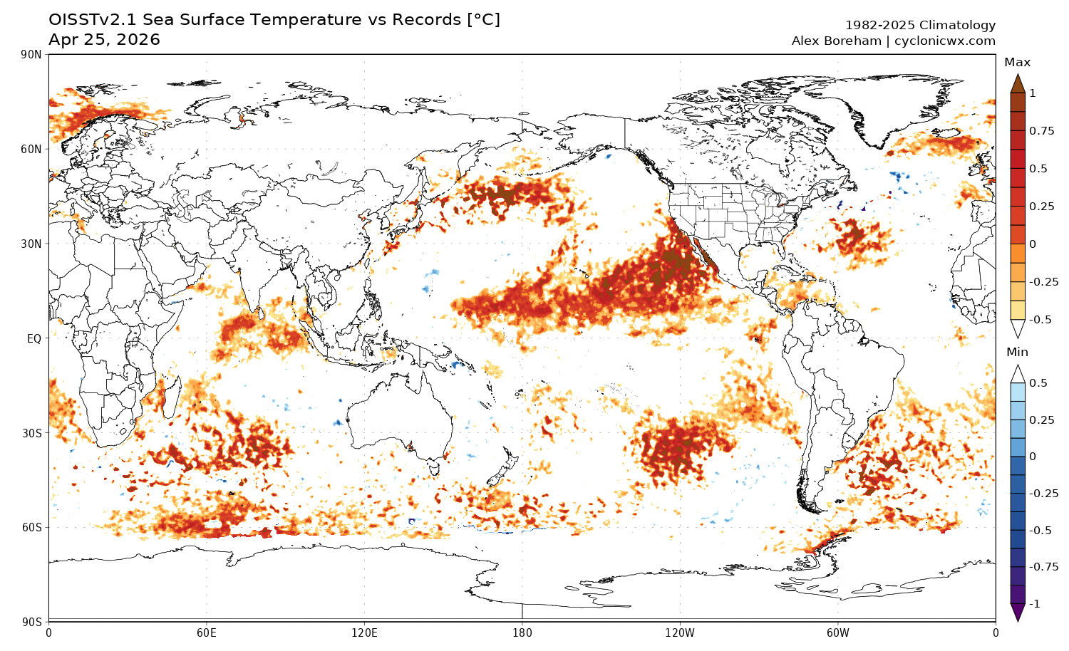
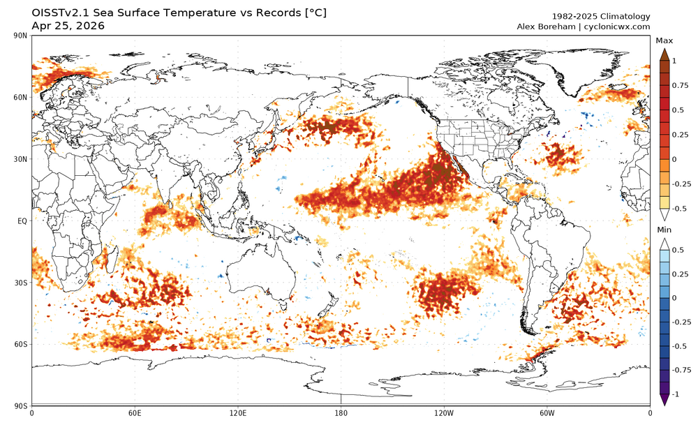
This chart shows where daily satellite SST is at record levels. Biggest feature is the large area of record warmth in the PMM area extending west of North America. An important area with nino conditions developing. There are also less extensive record temperatures in the southern hemisphere Pacific south of the enso region. https://cyclonicwx.com/sst/

.thumb.gif.f92b16c631a1d15d405ed77b33f0710d.gif)