All Activity
- Past hour
-

The Jan 31 Potential: Stormtracker Failure or 'Tracker Trouncing
paulythegun replied to stormtracker's topic in Mid Atlantic
The WeatherNext 2 trend over the last 4 runs through 06z is NW, NW, NW. Found this in another forum, cleaned it up.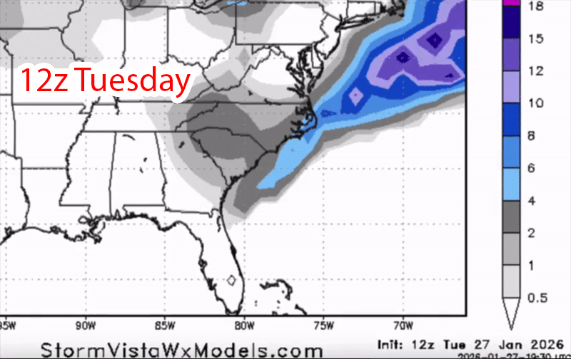
-

Possible coastal storm centered on Feb 1 2026.
ChangeofSeasonsWX replied to Typhoon Tip's topic in New England
Yeah 2005 was definitely special for the Cape but not many of us lived out there to experience it. -
Yeah I’ll get one out this afternoon. Had meetings most of the morning, but ready to see what the euro has for us.
-
 I have paths around the house that could become almost tunnel like with another big one. The dogs can't see over the top as is, almost like a maze for them.
 -

Possible coastal storm centered on Feb 1 2026.
40/70 Benchmark replied to Typhoon Tip's topic in New England
Ooops, beat me to it. -
Possible coastal storm centered on Feb 1 2026.
40/70 Benchmark replied to Typhoon Tip's topic in New England
2005 was comparable to the worst 78 had to offer on the cape. -
Possible coastal storm centered on Feb 1 2026.
ChangeofSeasonsWX replied to Typhoon Tip's topic in New England
True. Actually the top three that I have memories of are 2005, 2022, and 2015. 2013 had viscious winds which was a plus as well. But my father tells me that 1978 was in a league of its own. I hope I get to see one like that in my life. -

The Jan 31 Potential: Stormtracker Failure or 'Tracker Trouncing
CAPE replied to stormtracker's topic in Mid Atlantic
There is always a cutoff on the north side. There is a precip shield on the NW side we just aren't in it. That low is pretty far south at that point . As the low moves NE and deepens the precip on the NW side becomes more impressive but its all offshore. -
 Including early November snow
 -
Possible coastal storm centered on Feb 1 2026.
DavisStraight replied to Typhoon Tip's topic in New England
Don't think we'd have the gridlock today with social media but would t o see a storm like that again. I remember back in 78 they thought the storm was too far East to give us a good hit, it wasn't til close to go time they realized what was happening. -
Way to many Boston references in there coming from a supposed New Yorker.
-
4 days until the first flakes would be flying. Nam isn't even in range yet
-
This is so close we are not going to have all the answers till at least Friday or Saturday IMO because there is a good chance of at least some snow in the Region
-
It's winter. We cold.
-

Possible coastal storm centered on Feb 1 2026.
CoastalWx replied to Typhoon Tip's topic in New England
2005 was 78-like over the Cape. Over 3' there with gusts 80+. -
Mid-Long Range Discussion 2026
WinstonSalemArlington replied to BooneWX's topic in Southeastern States
February 4 Storm -

Possible coastal storm centered on Feb 1 2026.
Wxbear25 replied to Typhoon Tip's topic in New England
I mean, if you want a snowstorm I feel like you want the NAM to verify at 500 here. Thats one I look at the 500MB pattern and think “how does this miss” Most of the other guidance I look at right now and say “how does this hit” I don’t trust those bowling-ball lows the GFS, CMC, and Euro have to produce since those are tough to drag northward as opposed to kick with more eastward force Of course it’s the 84hr NAM so… -
Anyone else enjoy torturing themselves by watching Deep Creek Lake webcams where it its just fluffy dendrites 24x7 for no reason at all and they just casually pickup a couple inches a day... while we do whatever it is we're doing down here...
-
Mid-Long Range Discussion 2026
WinstonSalemArlington replied to BooneWX's topic in Southeastern States
I love nonstop cold$ -

Richmond Metro/Hampton Roads Area Discussion
Conway7305 replied to RIC Airport's topic in Mid Atlantic
the only thing positive I can post is the 12z GEGS ensemble members. Lots of good hits for now.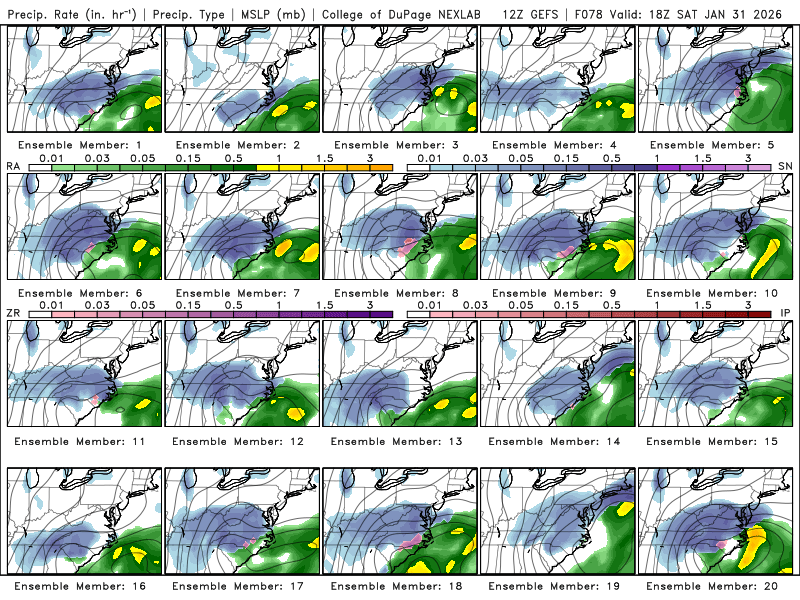
-
Who is starting the February 4 South Carolina-Wilmington-East Georgia Storm thread
-

The Jan 31 Potential: Stormtracker Failure or 'Tracker Trouncing
EHoffman replied to stormtracker's topic in Mid Atlantic
Uccellini right again "I'd rather be in Myrtle Beach" -
Yeah I swore I was going to start a weather blog this season but between life and a big promotion at work I've not had a lot of time. Women also... Been busy there also lol.
-

1-30/2-1-26 Arctic Blast, ULL Snow Event
Holston_River_Rambler replied to John1122's topic in Tennessee Valley
That is a pretty look for sure.- 58 replies
-
- 2
-

-
- extreme cold
- snow
- (and 1 more)
-
Not at all. It’s a very volatile setup where small changes aloft can result in significant changes at the surface. That said there are larger features that aren’t favorable-the kicker coming from the Dakotas, early closing off and positive tilt. We need one or two of those to change around soon.


