All Activity
- Past hour
-

November 2025 general discussions and probable topic derailings ...
Layman replied to Typhoon Tip's topic in New England
We’re going to get a place up here at some point. Just need to find the -right- one. -
 Partly cloudy. A gusty breeze. 36.5°
 -

Central PA Fall Discussions and Obs
Blizzard of 93 replied to ChescoWx's topic in Upstate New York/Pennsylvania
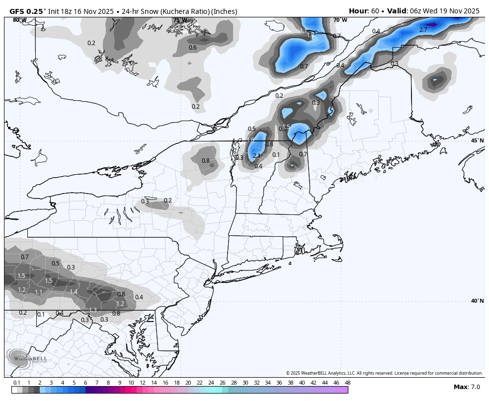
18z GFS has a little light snow showing this run on Tuesday early evening for the LSV with a weak wave.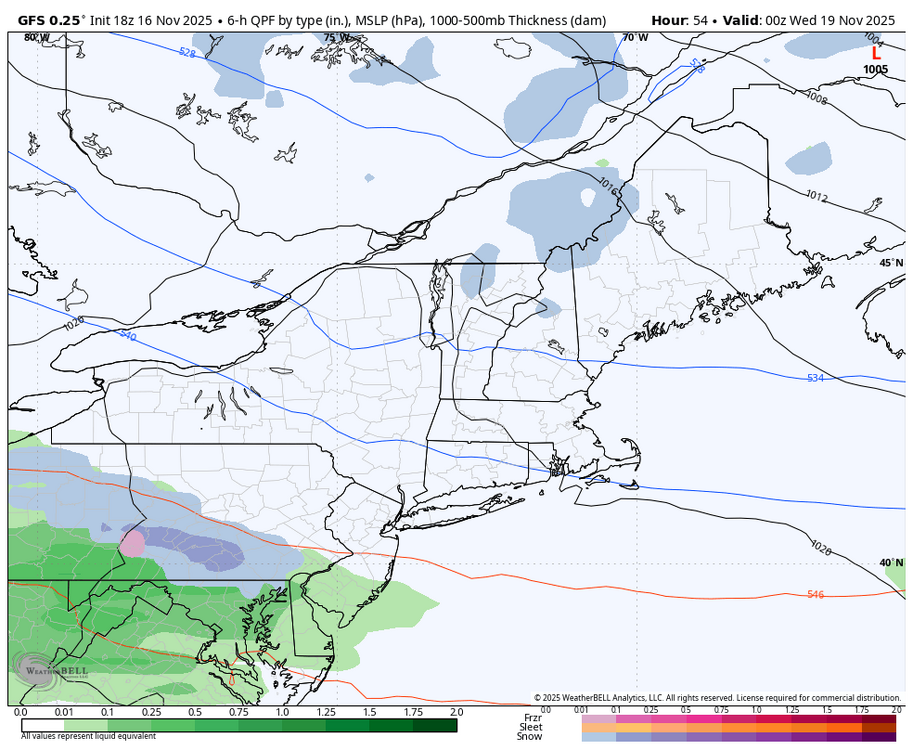

-

November 2025 general discussions and probable topic derailings ...
dendrite replied to Typhoon Tip's topic in New England
That’s looks more like a NYC snowman within 30 minutes after making it. -
A colder air mass is now overspreading the region. The wind will diminish tonight. Below normal temperatures will prevail through at least Wednesday and possibly Thursday. Highs will be mainly in the middle and upper 40s in New York City with lows in the middle and upper 30s. A milder pattern will likely develop during the latter part of the week. Some rain or rain showers are possible. Once in place, the milder pattern could continue for a week or longer. If so, that could tip the odds toward a warmer than normal monthly mean temperature. Meanwhile, today will be Central Park's 1,387th consecutive day without daily snowfall of 4" or more. The record of 1,394 days was set during February 22, 1929 through December 16, 1932. That stretch ended with 6.7" daily snowfall on December 17, 1932. The ENSO Region 1+2 anomaly was -0.2°C and the Region 3.4 anomaly was -0.7°C for the week centered around November 5. For the past six weeks, the ENSO Region 1+2 anomaly has averaged -0.07°C and the ENSO Region 3.4 anomaly has averaged -0.55°C. La Niña conditions will likely continue through at least mid-winter. The SOI was +8.20 today. The preliminary Arctic Oscillation (AO) was -1.552 today. Based on sensitivity analysis applied to the latest guidance, there is an implied 53% probability that New York City will have a cooler than normal November (1991-2020 normal). November will likely finish with a mean temperature near 47.7° (0.3° below normal). Supplemental Information: The projected mean would be at the 1981-2010 normal monthly value.
-
Unfortunately, it won’t matter if the Ravens can’t stop the run.
-
.thumb.jpg.6a4895b2a43f87359e4e7d04a6fa0d14.jpg)
Central PA Fall Discussions and Obs
Yardstickgozinya replied to ChescoWx's topic in Upstate New York/Pennsylvania

-
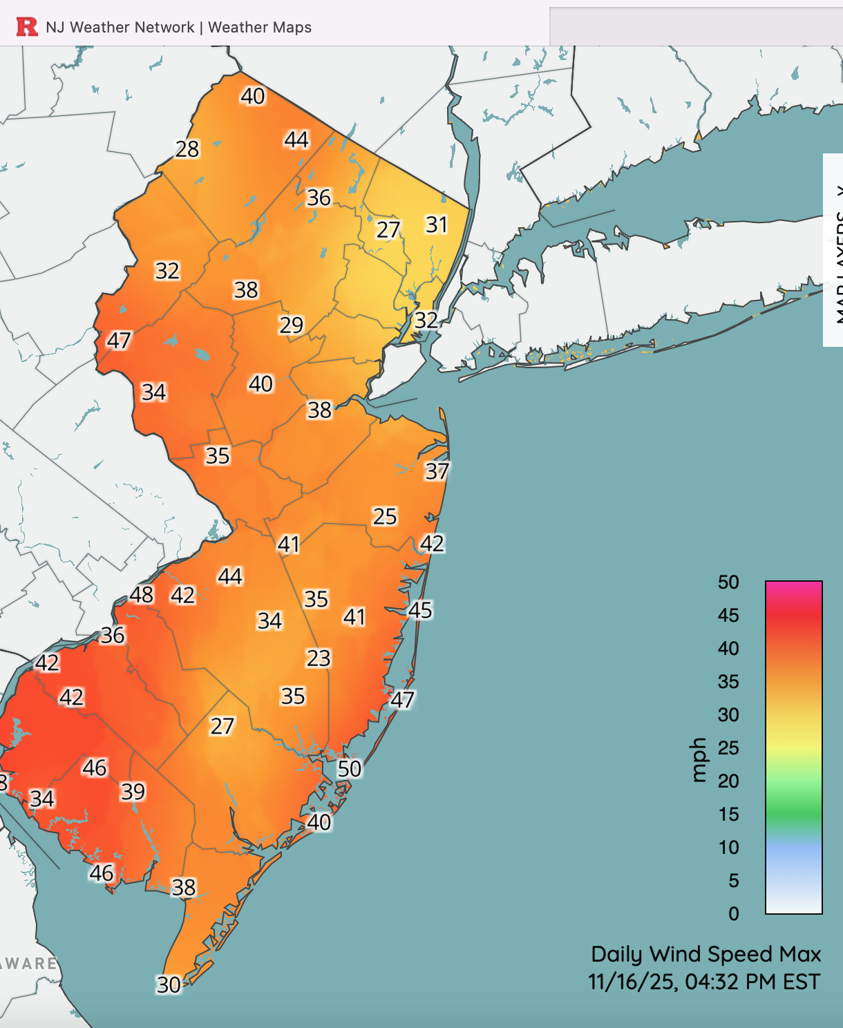
 Probably my last post of the day... Maybe someone could add when PHI and OKX publish a PNS of updated wind reports. Click for clarity. Thanks for your supporting OBS. .
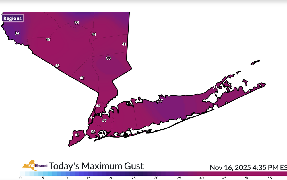

-
 We got it for the location--it's in the village, 30 steps to the water. The house is a disaster!! My wife said our prior houses have prepared us for this moment.
 -
November 2025 general discussions and probable topic derailings ...
dendrite replied to Typhoon Tip's topic in New England
Make a sleetman -
 Sleet . Hold me tight
 -
Multitude of reports 40Kt plus since 1PM... note the 47KT at Newark and many 43-46 KT showing up from SNE to PANJ KAGC: Pittsburgh, Allegheny County Airport, PA, United States [42kt, 22m/s] KALB: Albany, Albany Intl Arpt, United States [43kt, 22m/s] KBAF: Westfield, Barnes Municipal Airport, MA, United States [45kt, 23m/s] KBDL: Windsor Locks, Bradley Intl Arpt, CT, United States [46kt, 24m/s] KBDR: Bridgeport, CT, United States [46kt, 24m/s] KBGM: Binghamton, Binghamton Regional Airport, NY, United States [44kt, 23m/s] KBWI: Baltimore, MD, United States [41kt, 21m/s] KCXY: Harrisburg, Capital City Airport, PA, United States [44kt, 23m/s] KDYL: Doylestown, Doylestown Airport, PA, United States [40kt, 21m/s] KELM: Elmira, Elmira / Corning Regional Airport, NY, United States [42kt, 22m/s] KEWR: Newark, Newark Intl Arpt, NJ, United States [47kt, 24m/s] KFIG: Clearfield, Clearfield-Lawrence Airport, PA, United States [40kt, 21m/s] KFIT: Fitchburg, Fitchburg Municipal Airport, MA, United States [40kt, 21m/s] KFOK: Westhampton Beach, NY, United States [43kt, 22m/s] KFRG: Farmingdale, Republic Airport, NY, United States [41kt, 21m/s] KHWV: Shirley, Brookhaven Airport, NY, United States [40kt, 21m/s] KIAD: Washington-Dulles Intl Arpt, VA, United States [41kt, 21m/s] KIPT: Williamsport, PA, United States [45kt, 23m/s] KJFK: JFK Intl Arpt, NY, United States [46kt, 24m/s] KLGA: New York, La Guardia Airport, NY, United States [43kt, 22m/s] KLNS: Lancaster, Lancaster Airport, PA, United States [46kt, 24m/s] KMDT: Harrisburg, Harrisburg Intl Arpt, PA, United States [48kt, 25m/s] KMGJ: Montgomery, Orange County Airport, NY, United States [40kt, 21m/s] KMIV: Millville, Millville Municipal Airport, NJ, United States [40kt, 21m/s] KMPO: Mount Pocono, PA, United States [42kt, 22m/s] KMRB: Martinsburg, WV, United States [40kt, 21m/s] KMTN: Baltimore / Martin, MD, United States [45kt, 23m/s] KMUI: Muir/Indiantown, PA, United States [42kt, 22m/s] KORH: Worcester, Worcester Regional Airport, MA, United States [40kt, 21m/s] KOWD: Norwood, Norwood Memorial Airport, MA, United States [40kt, 21m/s] KPHL: Philadelphia, Philadelphia Intl Arpt, PA, United States [43kt, 22m/s] KPNE: NE Philadelphia, PA, United States [43kt, 22m/s] KPOU: Poughkeepsie, Dutchess County Airport, NY, United States [44kt, 23m/s] KPYM: Plymouth, MA, United States [40kt, 21m/s] KRDG: Reading, Reading Regional Airport, PA, United States [46kt, 24m/s] KROA: Roanoke, Roanoke Regional Airport, VA, United States [42kt, 22m/s] KRSP: Campd David, MD, United States [47kt, 24m/s] KRVL: Reedsville / Mifflin, PA, United States [45kt, 23m/s] KSWF: Newburgh / Stewart, NY, United States [40kt, 21m/s] KTHV: York, York Airport, PA, United States [45kt, 23m/s] KTTN: Trenton, Mercer County Airport, NJ, United States [40kt, 21m/s] KVAY: Mount Holly, NJ, United States [42kt, 22m/s]
-

November 2025 general discussions and probable topic derailings ...
ineedsnow replied to Typhoon Tip's topic in New England
We snow/sleet mulch turning a bit white -
Yeah, most of the snow north of the South Shore on radar remained aloft for hours with the subzero dewpoints and strong high pressure.
-
not really it feels like mid july..
-
 Mattapoisett is pretty sweet
 -
 57F and now 46F we take.
 -
Beautiful April afternoon
-
https://x.com/bennollweather/status/1990036396615274867?s=46 .
- Today
-
Justice Hill is inactive. That should mean increased touches for Keaton Mitchell. Given how poor the Ravens OG play has been- and the Browns standout DL, Henry will probably find it difficult to get going. Mitchell has the combo of quickness and speed that can make the difference. He damn well better be a big part of the game plan.
-
This shows that the Euro is now leaning toward that later period for the actual reversal (~11/28 instead of 11/25). Add in a several week lag and a potential of a phase 8 MJO followed hopefully by 1-2 and we’d have a realistic chance for a several week long period of cold domination in the E US starting as early as near mid-Dec. Prior to this potential, there’d also likely be a mild dominated next 30 days, which shouldn’t be ignored.
-

November 2025 general discussions and probable topic derailings ...
alex replied to Typhoon Tip's topic in New England
Welcome to the Woods! -
We still have Pit2, so I'll still have a winter. At least for one more year.