All Activity
- Past hour
-

2026-2027 Super El Nino
mitchnick replied to Stormchaserchuck1's topic in Weather Forecasting and Discussion
Won't be a record year, save the highest elevations. No one has said otherwise. But it's incredible how just posting model progs can cause such a stir. But as I said in my post to Michigan, no seasonal forecasts I've seen are flat out furnaces in the east. That and the surprisingly cold forecasts by at least the Cansips and Jamstec make me at least optimistic for a few snow chances considering the AN precip along the coast by most models. -
compare the 12Z NAM to the 18Z NAM and you will see it has no idea how much and where the rainfall will occur
-
Still grilled. I don’t think the heavy stuff is coming for awhile yet.
-

2026-2027 Super El Nino
40/70 Benchmark replied to Stormchaserchuck1's topic in Weather Forecasting and Discussion
The northeast doesn't need a cold winter for decent snowfall, but I agree that it won't be cold. 2010-2011 was actually one of the best seasons on record up here. -
645 pm or so
-

Junorch obs and discussion 2026
Damage In Tolland replied to Damage In Tolland's topic in New England
WTTE. They said 70’s thru mid July and blue -
While I have not looked at anything for tomorrow in detail, it could be an under the radar type of day for those in northern AL into the TN Valley for a potential chase day. If I was closer and/or had the day off tomorrow, I would take the gamble to chase, but unfortunately, I am not in that position to chase for that setup. On the side note, would love to be in CO/NE/KS this week to chase landspouts given that the pattern for tomorrow looks to be favorable for it once again across that area, maybe one day I will see one. Date: 6/21/2026 @ 6:00 PM CDT
-
-
Can we make it 4 for 4?
-

2026-2027 Super El Nino
Stormchaserchuck1 replied to Stormchaserchuck1's topic in Weather Forecasting and Discussion
I'm a believer in utilizing reverse conditions. The dataset is limited, so historically La Nina's look different than the reverse of El Nino's (they both aren't warm in the east when strong). Some of that is because El Nino's tend to be more east-based, but there is still discrepancy in the reversals. -

2026-2027 Super El Nino
raindancewx replied to Stormchaserchuck1's topic in Weather Forecasting and Discussion
The truth is you guys in the Northeast probably won't get too much snow. In your favor - 1) Very wet conditions are likely. 2) Some blocking is likely later on. Not in your favor - 1) -PDO is a negative PNA tendency. I expect PNA finishes positive in Nov-Mar, but not by much in a few of the periods. There won't be a whole of lot of shots at big nor'easters when it is cold. 2) -AMO trend pushes storms to the South. I had storms miss me (in the desert) in 2010-11, 2009-10, 2011-12, and 2018-19 to the South - same applies in the Northeast. 3) Three cold winters in a row is rare for the Northeast, and should not be the expected outcome. 4) Sort of looks to me like a -WPO in the Fall which will build up cold in Canada, and then it gets warmed up and dispersed in winter when it flips later on. -
12 tornado reports in Illinois so far
-
Only 0.03” here. Still one more cell trying to drop in from the NW. 3k and rufus dump up here
-

2026-2027 Super El Nino
MJO812 replied to Stormchaserchuck1's topic in Weather Forecasting and Discussion
Hes a troll -
2026-2027 Super El Nino
MJO812 replied to Stormchaserchuck1's topic in Weather Forecasting and Discussion
Your track record predicting long range forecasting is atrocious. How did your winter forecast turn out last winter ? -
2.17" so far. Nice soaker.
-
Junorch obs and discussion 2026
Damage In Tolland replied to Damage In Tolland's topic in New England
You’ve gotten hit multiple times already -

Junorch obs and discussion 2026
backedgeapproaching replied to Damage In Tolland's topic in New England
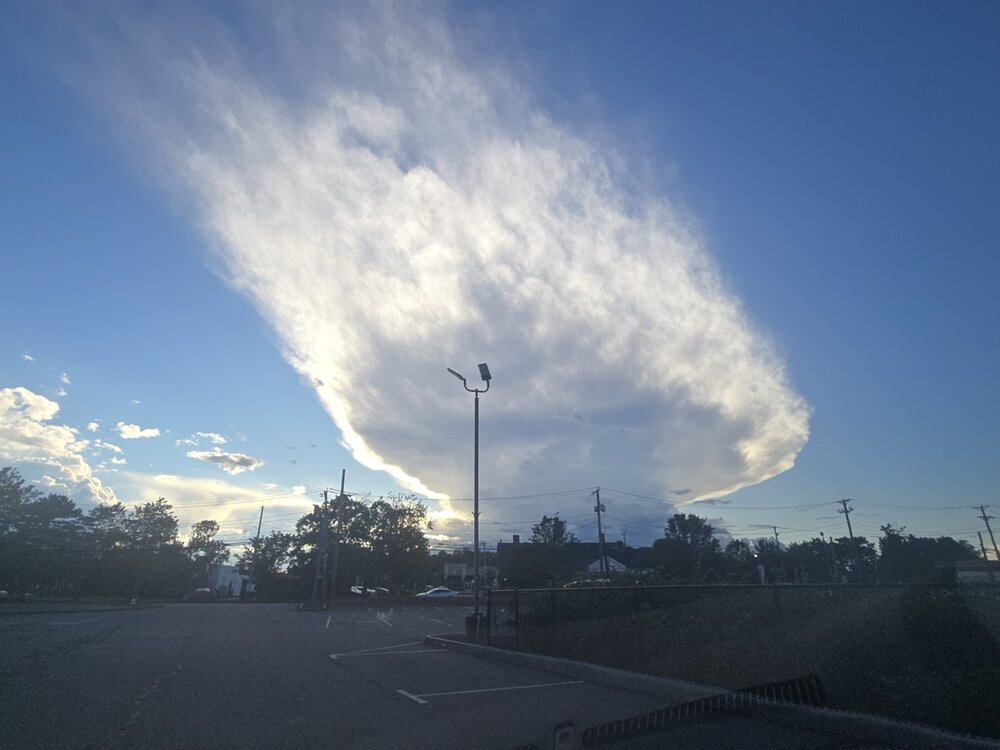
More storms rolled through, cleared out nicely this evening for grill, steak and some beverages outside.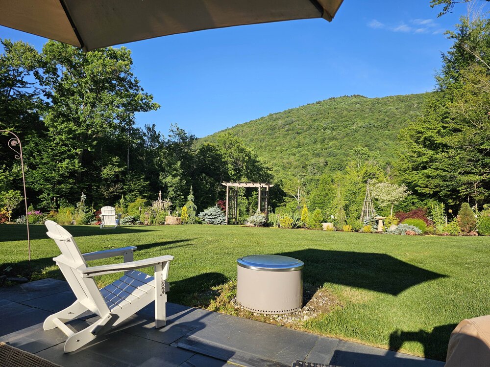
-

2026-2027 Super El Nino
Santa Claus replied to Stormchaserchuck1's topic in Weather Forecasting and Discussion
i am humble enough to pay tribute to my betters - Today
-

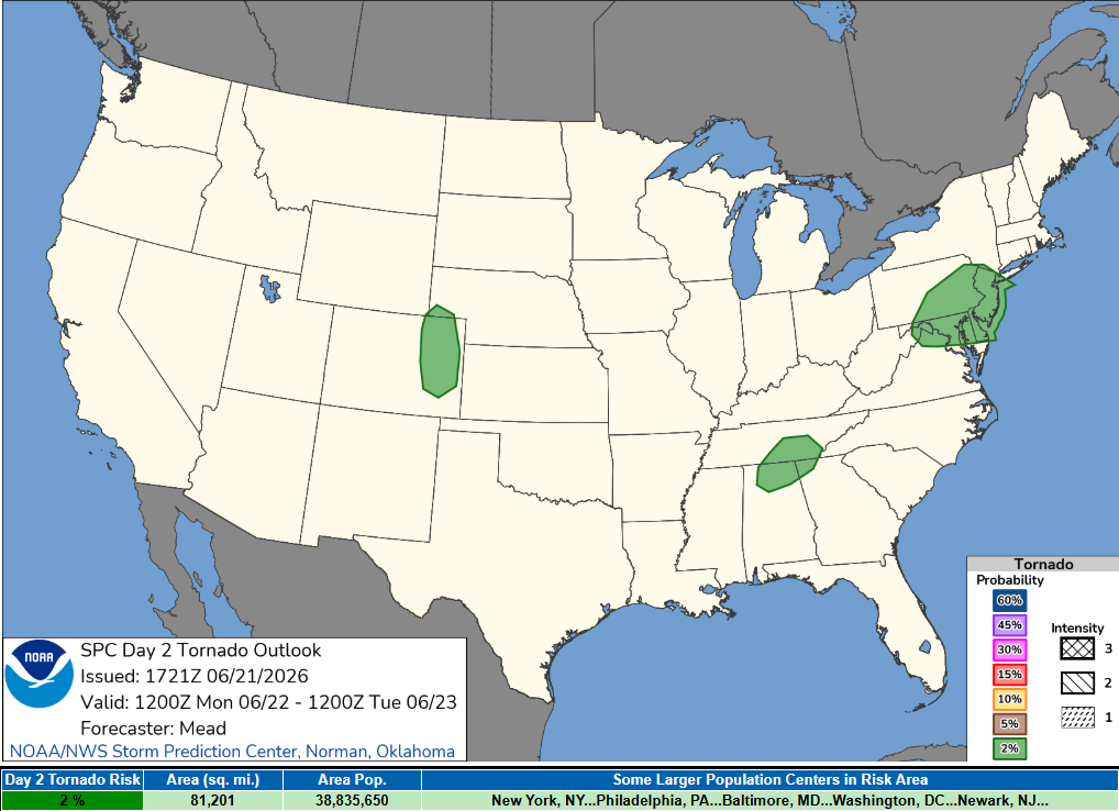
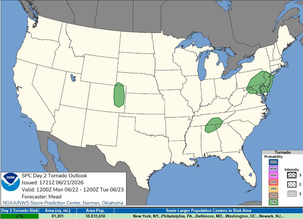
Wet late Monday 6/22 or another Fizzle?
Weather Will replied to Weather Will's topic in Mid Atlantic
Can you pin this thread through Tuesday? Thanks! -
My rain total is 0.47", on the low end of guidance. This is about as awful as a June day can get. It feels like April. Let's get back to warm and humid with storms.
-
Stand up straight and mind the ticks. As always ….

-
ya because the 0.1” of rain I got earlier was so satisfying
-
It’s gonna take repeated punches from giga-Nino. And a few more months until those start I think.
-
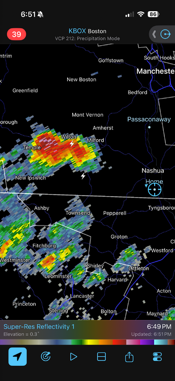
ILC081-191-212300- /O.CON.KPAH.TO.W.0038.000000T0000Z-260621T2300Z/ Wayne IL-Jefferson IL- 522 PM CDT Sun Jun 21 2026 ...A TORNADO WARNING REMAINS IN EFFECT UNTIL 600 PM CDT FOR WEST CENTRAL WAYNE AND NORTHEASTERN JEFFERSON COUNTIES... At 522 PM CDT, a confirmed large and extremely dangerous tornado was located near Bluford, or 11 miles northeast of Mount Vernon, moving east at 25 mph. This is a PARTICULARLY DANGEROUS SITUATION. TAKE COVER NOW! Just another day in Illinois, Intense to violent tornado ripping through. Wicked debris ball.


.thumb.gif.f92b16c631a1d15d405ed77b33f0710d.gif)

.thumb.jpg.049f4a7f726ada07e8cd30bd17e713cb.jpg)