All Activity
- Past hour
-
Personally I've hiked some of the easy 14ers, mainly easy ones, plus 12000-13000 were really nice a number of times. I hiked Long's twice, which is not easy, and it was not really that easy on me the 2nd time. For some reason I joined with my hiking group to do the Kelso ridge on Torrey's Peak, and that involved scooting on the "knife edge." So, Torrey's could have been a lot easier, but I decided to risk my life, kind of like Long's Peak. Silly me. I hiked Mt. Richthofen at RMNP from the Agnes Lake parking lot. That was a terrific view, and my friend and I had to fight against a little crumbly crap. The view was worth it. We were the only two people on the mountain. Not much of a developed trail. And I did that on a Labor Day some time in the past.
-
I speculate there will be lot of wish casting, meltdowns, and season cancellations.
-
Interesting Don…. So (as of today) Accu Weather long range is predicting 2026 will have the latest of all three. Of course their 90 day long range does/can adjust daily. When it comes to the cold season the double L L …. Lessor and later seems to prevail. As always ……
-
Any analogs show up with strong El Nino’s with extraordinarily low Atlantic ACE’s the preceding tropical season?
-

Septorcher 2026 Discussion - Endless Summer
Baroclinic Zone replied to Damage In Tolland's topic in New England
All day, every day weather. Cool AM, warm afternoon. Throw in some rains here and there and I’m sold. -

2026-2027 Record-breaking El Nino
michsnowfreak replied to Stormchaserchuck1's topic in Weather Forecasting and Discussion
This is a trademark of climate for the east coast (particularly NYC south) and the Mid-Atlantic. Which is why I dont understand the panic from some over an expected milder than average mean over a 90 day period. Especially with the overwhelming signal for above avg precip in the east. It is different here in the Great Lakes. Big storms are usually in the 6-12" range but snow is much more frequent than the east coast. So my worry about a crummy winter is not that it wont snow- it will many times- its that in the end total snow, snowcover, and stretches of sustained/deep winter are almost always less than average in strong ninos. I imagine its similar in new England, and even though they do get massive noreasters, i cant imagine 1 storm would make or break their season as it would further down the coast. -
 tamoxifen citrate [url=https://nolvacare.com/#]nolvadex 20mg[/url] :: liquid tamoxifen
 -
2026-2027 Record-breaking El Nino
michsnowfreak replied to Stormchaserchuck1's topic in Weather Forecasting and Discussion
For me its sweaters and those cold nights with mild sunny days. The smell of the air. October is amazing in Michigan and theres really very few weather patterns that can ruin it. -
Too much UHI these days to easily secure lows in the 50s before late september. We will smash the record likely.
-
Absolutely a stellar day on Lake Keowee today. Current temp of 74 and overcast.
-
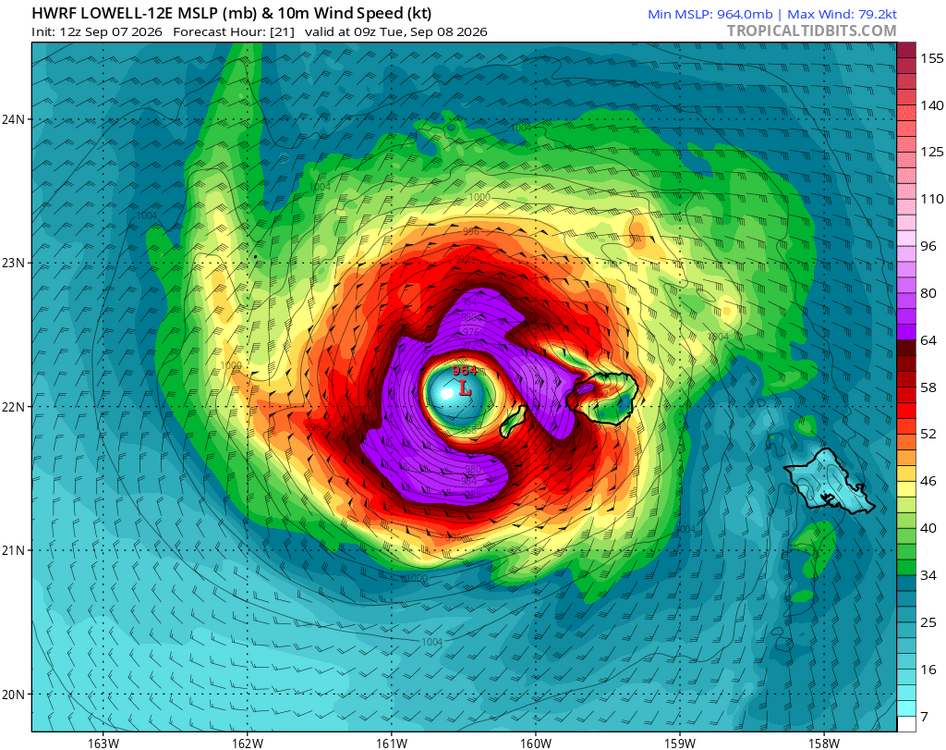
Recent eastward trends have made things a lot more interesting for Kauai.
-

2026-2027 Record-breaking El Nino
raindancewx replied to Stormchaserchuck1's topic in Weather Forecasting and Discussion
Again, we are tracking the last four El Ninos rather well as a blend. -
2026-2027 Record-breaking El Nino
raindancewx replied to Stormchaserchuck1's topic in Weather Forecasting and Discussion
Roughly 20F off so far for parts of Iowa. No big deal. Only 10-15F or so by CA/OR so far. La Nina Modoki / El Nino traditional tend to favor the West Cold Fall-Spring (E Pac relatively warm v. W Pac at the equator in each case). -

Septorcher 2026 Discussion - Endless Summer
ineedsnow replied to Damage In Tolland's topic in New England
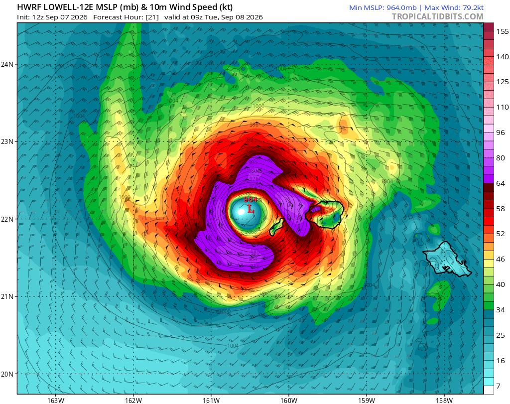
pretty big east jog with Hurricane Lowell.. it now looks like the Northern islands get into the good stuff -
https://cytocarepharma.shop/# buy cytotec
-
Would be a top ten day of the wind let up
-
Another .34'' from a cell that was moving southwest last evening,almost 2'' for the month.
-
Down to 53 here last night. Was great to sleep with the windows open and the blankets up.
- Today
-
(002).thumb.png.6e3d9d46bca5fe41aab7a74871dd8af8.png)
Central PA Summer 2026 Discussion/Obs Thread
ChescoWx replied to Voyager's topic in Upstate New York/Pennsylvania
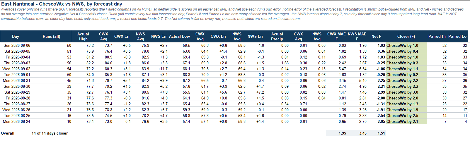
With now 2 weeks of forecasts in the books the ChescoWx model has performed a bit better than the official NWS forecast every day for my backyard here in East Nantmeal Township.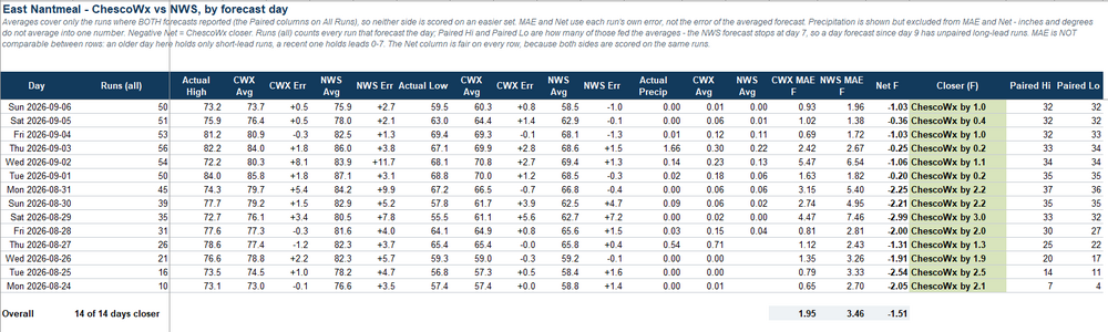
-
E PA/NJ/DE Autumn 2026 Obs/Discussion
ChescoWx replied to PhiEaglesfan712's topic in Philadelphia Region
With now 2 weeks of forecasts in the books the ChescoWx model has performed a bit better than the official NWS forecast every day for my backyard here in East Nantmeal Township.
-

2026-2027 Record-breaking El Nino
Chinook replied to Stormchaserchuck1's topic in Weather Forecasting and Discussion
I am wondering how the El Nino may already be shifting 250mb winds, even as we've just started, in summer. Obviously, we'll expect lots of subtropical jet in winter. As for now, I used the HISTDATA from NOAA to plot this... it's essentially the same as NCEP/NCAR reanalysis but it lacks some capabilities. Anyway, the 250mb zonal winds have been more westerly than average for some of the E Pacific, into southern Mexico, then out to the Atlantic. You can see the evidence of a ridge over the central USA. Now, we know El Nino tends to have these situations where the wind shear is quite high for the Atlantic hurricane season and squash that. But here's the question: if the 250mb winds were so westerly, why has the E Pacific generated some strong storms? Of course, on here, there's the Hawaii area ,which has had a hurricane this summer (and now a couple more storms by Hawaii), with the more-easterly-than-average winds as shown. -

2026-2027 Record-breaking El Nino
GaWx replied to Stormchaserchuck1's topic in Weather Forecasting and Discussion
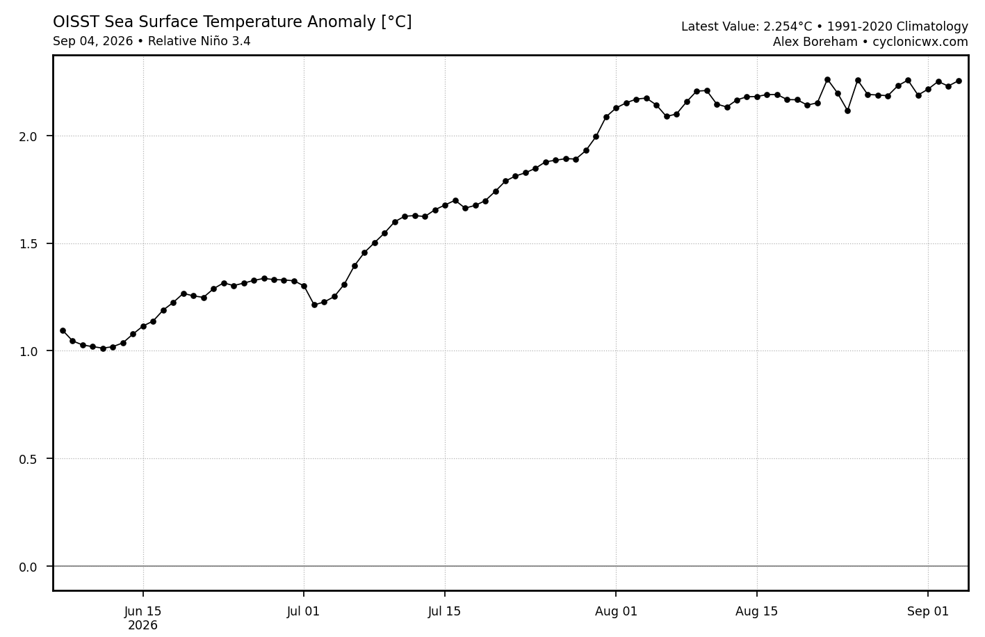
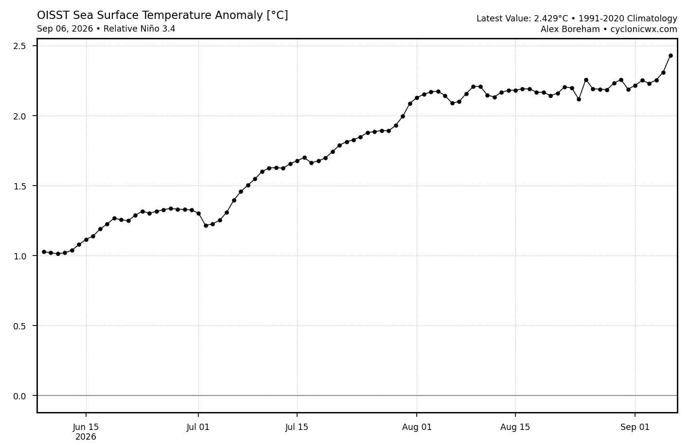
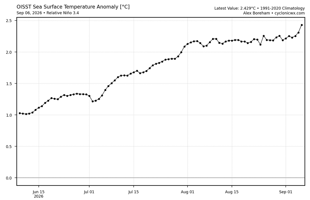
After being pretty flat in August/first few days of Sept, the relative 3.4 OISST anomaly has risen sharply the last two days: Sept 4th relative 3.4: +2.254 Sept 6th relative 3.4 anomaly: +2.429, a rise of 0.175 in just two days…that’s the most rapid two day rise on this entire chart as it is the most rapid two day rise since June 3rd-5th, which is not on this chart: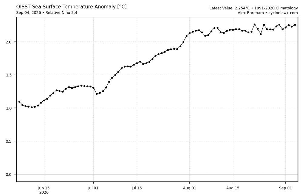
-
Dipped below 60 for the first time at my location since mid-June. Very cool feel this morning but it's rebounding quickly through the low 80s right now. Great windows open weather to let some of this dry air flow in.
-

Winter 2026-2027 Speculation
Prismshine Productions replied to 40/70 Benchmark's topic in New England
-5 for me is still 50+" so would take in a heartbeat Sent from my SM-S176V using Tapatalk -
2026-2027 Record-breaking El Nino
GaWx replied to Stormchaserchuck1's topic in Weather Forecasting and Discussion
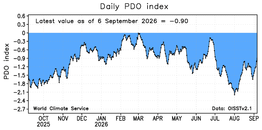
The daily WCS PDO has risen back substantially the last 7 days ending yesterday with it up to -0.9, the highest since way back on July 2nd, vs ~-1.65 one week earlier: