All Activity
- Past hour
-

2025 Atlantic Hurricane Season
Maestrobjwa replied to BarryStantonGBP's topic in Tropical Headquarters
Baking that must take forever... -
Jimmy Buffet on repeat in the background. Tie dye shirts only. Sign above the bar that says “Aren’t you glad you aren’t paving I-93?”
-
Get well soon. This should brighten your day.
-
If winter actually returns I’ll be right there with Ineedsnow. But these recent summers have been such a treat after 3 catastrophic winters.
-
thankfully there are antibiotics that you can take at least despite there not being a lymes disease vaccine out yet i kind of wish that one from the early 2000s could be brought back even though low demand
-
I would swim every day if I could. Just love that tropical vibe. Makes me want to live at a beach bar with a hemp necklace and put out chairs for people.
-
Something about this weather brings out past traumas…
-
Sadly there is no current Lyme vaccine. There was one that was discontinued in the early 2000s due to the manufacturer citing low demand. A new one is in clinical trials I believe. kind of shocked how I’ve never knowingly had it. I’m in the woods a bunch.
-
Do you swim every day? Is that why you don’t like this pleasant weather? Did Morgarbage’s teeet a couple of weeks ago hit too close to home for you? I don’t get it. Even with swimming it would only be mildly uncomfortable.
-

Hurricane Erin: 140 MPH - 935 mb - NW @ 12
GaWx replied to BarryStantonGBP's topic in Tropical Headquarters
Slezak may get a win for his “likely Carolinas” prediction. @BarryStantonGBP -

2025 Short Range Severe Weather Discussion
pen_artist replied to Chicago Storm's topic in Lakes/Ohio Valley
Got a TOR warning now just west of Elgin -
I have heard of reports of some 40 to 50 mile distances in the past. So 25 does not surprise me. Still could be a dreadful wakeup call though.
-
You are going to get two X outs or shit emojis from DIT and his chimp sidekick.
-
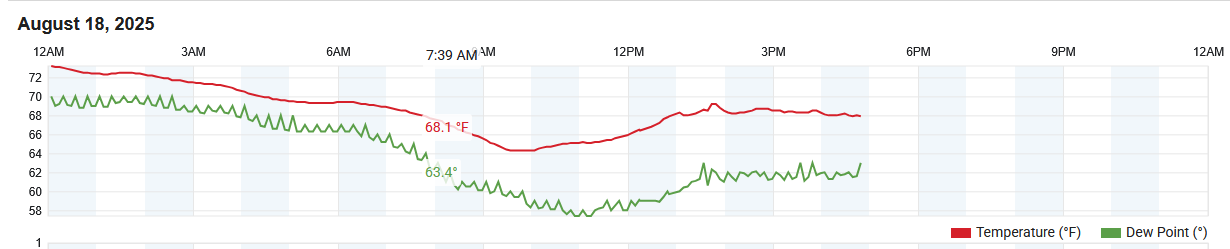
As I mentioned this morning - in fact many spots across the area stayed in the 60's all afternoon - including Atglen, East Nantmeal, Glenmoore, Nottingham and Longwood Gardens to name a few - for sure an unseasonably chilly Mid August afternoon! Below is from my station in East Nantmeal.

-

E PA/NJ/DE Summer 2025 Obs/Discussion
ChescoWx replied to Hurricane Agnes's topic in Philadelphia Region
As I mentioned this morning - in fact many spots across the area stayed in the 60's all afternoon - including Atglen, East Nantmeal, Glenmoore, Nottingham and Longwood Gardens to name a few - for sure an unseasonably chilly Mid August afternoon! Below is from my station in East Nantmeal.
-
He looks ready. He’s gonna be a great hitter.
-

Hurricane Erin: 140 MPH - 935 mb - NW @ 12
WxWatcher007 replied to BarryStantonGBP's topic in Tropical Headquarters
CHANGES WITH THIS ADVISORY: A Tropical Storm Watch has been issued from Beaufort Inlet to Duck, North Carolina including Pamlico Sound A Storm Surge Watch has been issued from Cape Lookout to Duck, North Carolina. -

Hurricane Erin: 140 MPH - 935 mb - NW @ 12
yoda replied to BarryStantonGBP's topic in Tropical Headquarters
Hurricane Erin Discussion Number 30 NWS National Hurricane Center Miami FL AL052025 500 PM EDT Mon Aug 18 2025 Erin's cloud pattern has become somewhat less organized than earlier today, likely as a result of some dry air intrusion over the northwestern portion of the circulation and increased northerly shear. An AMSR microwave image from the GCOM satellite showed the dry air intrusion which is consistent with the presence of arc clouds emanating northwestward from the system. The northerly shear has also begun to restrict the outflow to the north of Erin. The intensity is held at 120 kt for now, pending observations from another Air Force Hurricane Hunter aircraft in a few hours. This intensity estimate is also consistent with a blend of objective values from UW-CIMSS. After a west-northwestward wobble earlier today, the hurricane has resumed its northwest course with a motion estimate of 310/9 kt. The track forecast reasoning remains basically unchanged. Over the next 72 hours or so, Erin should turn northward and move through a weakness in the subtropical ridge, and on the western side of a mid-level anticyclone. Later in the forecast period, an approaching mid-level trough should cause Erin to accelerate northeastward over the northern Atlantic. The model guidance and low-level water vapor imagery suggests that the dry air incursion into Erin is probably temporary. However, given the degraded cloud pattern and the less conducive shear over the system, not much additional strengthening is likely. In any event since the system will remain over warm waters for at least the next 72 hours, Erin will likely retain major hurricane status through the middle of the week. The official intensity forecast is at the high end of the model guidance. Erin's continued expanding wind field will result in rough ocean conditions over much of the western Atlantic. It should be noted that the 34- and 50-kt wind speed probabilities beyond 36 hours in the text and graphical products are likely underestimating the risk of those winds occurring. This is because the forecast wind field of Erin is considerably larger than average compared to the wind field used to derive the wind speed probability product. KEY MESSAGES: 1. Bands of heavy rainfall are expected over portions of Hispaniola this evening, and through Tuesday for the Turks and Caicos, the southeast Bahamas, and the easternmost central Bahamas. Flash and urban flooding are possible. 2. Tropical storm conditions are expected in the Turks and Caicos Islands and in the southeast Bahamas through this evening. Tropical storm conditions are possible in portions of the central Bahamas tonight through Tuesday. 3. Erin is expected to produce life-threatening surf and rip currents along the beaches of the Bahamas, much of the east coast of the U.S., Bermuda, and Atlantic Canada during the next several days. Beachgoers in those areas should follow advice from lifeguards, local authorities, and beach warning flags. 4. Tropical storm conditions and coastal flooding are possible in the North Carolina Outer Banks beginning late Wednesday where Tropical Storm and Storm Surge Watches are in effect. Interests in Bermuda should also monitor the progress of Erin as strong winds are possible beginning on Thursday. FORECAST POSITIONS AND MAX WINDS INIT 18/2100Z 24.0N 71.3W 120 KT 140 MPH 12H 19/0600Z 24.9N 71.9W 120 KT 140 MPH 24H 19/1800Z 26.5N 72.8W 115 KT 130 MPH 36H 20/0600Z 28.4N 73.5W 105 KT 120 MPH 48H 20/1800Z 30.5N 73.7W 100 KT 115 MPH 60H 21/0600Z 32.7N 73.0W 100 KT 115 MPH 72H 21/1800Z 34.8N 71.2W 95 KT 110 MPH 96H 22/1800Z 38.0N 64.0W 85 KT 100 MPH 120H 23/1800Z 41.0N 56.5W 75 KT 85 MPH $$ Forecaster Pasch -

Hurricane Erin: 140 MPH - 935 mb - NW @ 12
Wannabehippie replied to BarryStantonGBP's topic in Tropical Headquarters
5:00 PM EDT Mon Aug 18 Location: 24.0°N 71.3°W Moving: NW at 10 mph Min pressure: 937 mb Max sustained: 140 mph -
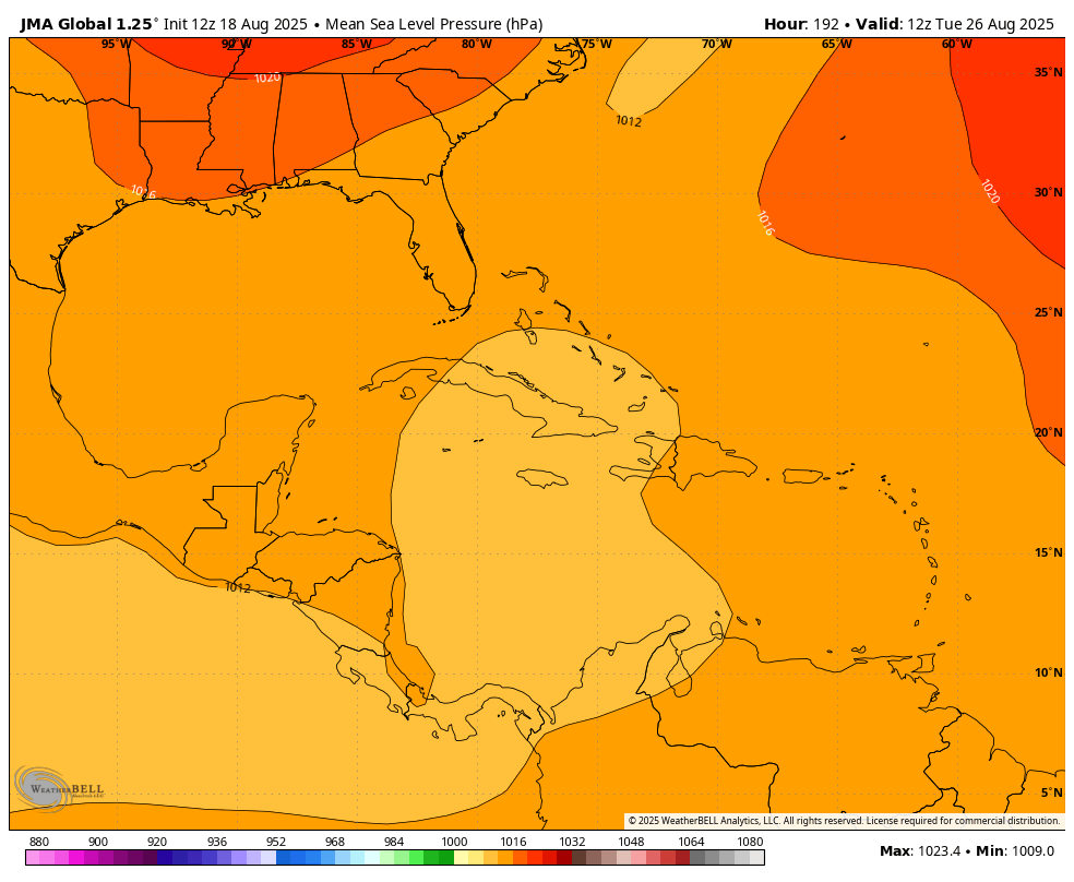
NEW DISTURBANCE: Central Tropical Atlantic (10/60)
GaWx replied to BarryStantonGBP's topic in Tropical Headquarters
12Z JMA fwiw also has it very weak but disagrees with the 12Z UKMET on the track with it near Cuba at 192: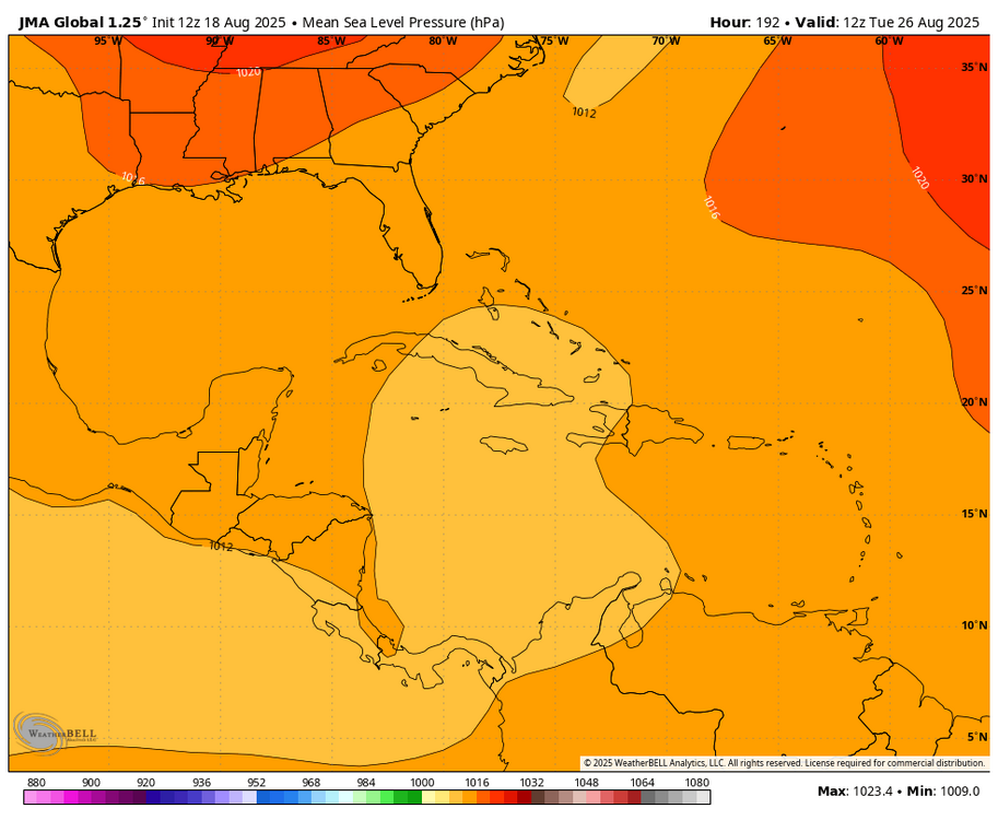
-
Watches have been issued for Mainland US as of the 5pm. advisory. WHO CARES!
-

Hurricane Erin: 140 MPH - 935 mb - NW @ 12
NJwx85 replied to BarryStantonGBP's topic in Tropical Headquarters
IR presentation is improving again as deep convection is wrapping around the Western half. -
NEW DISTURBANCE: Central Tropical Atlantic (10/60)
GaWx replied to BarryStantonGBP's topic in Tropical Headquarters
12Z UKMET: aiming for Bermuda and weak (only a TD this run)NEW TROPICAL CYCLONE FORECAST TO DEVELOP AFTER 96 HOURSFORECAST POSITION AT T+ 96 : 18.7N 59.7WLEAD CENTRAL MAXIMUM WINDVERIFYING TIME TIME POSITION PRESSURE (MB) SPEED (KNOTS)-------------- ---- -------- ------------- -------------1200UTC 22.08.2025 96 18.7N 59.7W 1010 280000UTC 23.08.2025 108 19.7N 62.4W 1009 281200UTC 23.08.2025 120 21.0N 65.2W 1010 280000UTC 24.08.2025 132 22.5N 67.0W 1011 261200UTC 24.08.2025 144 24.0N 68.0W 1013 290000UTC 25.08.2025 156 26.8N 67.7W 1013 291200UTC 25.08.2025 168 29.5N 66.1W 1014 29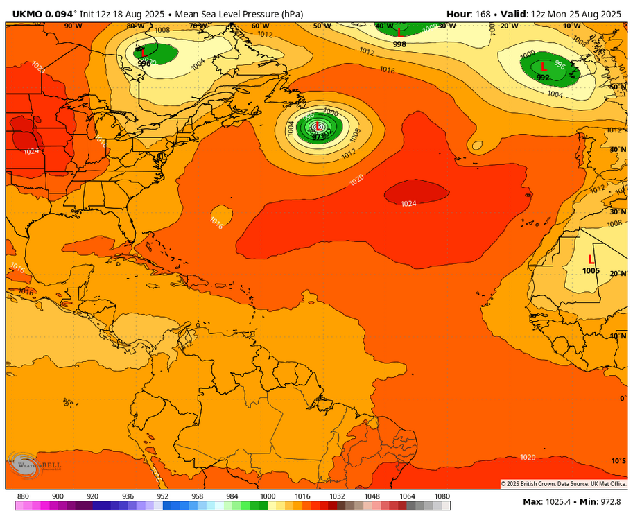
-
 A dramatic change to a sustained period of cooler weather has now occurred. High temperatures will likely reach the middle and upper 70s through Wednesday and then the lower 80s on Thursday and Friday. The extended range guidance continues to suggest that the closing week of August could feature below normal temperatures. Precipitation could be near normal. The synoptic pattern should limit direct tropical cyclone threats for the foreseeable future. Impacts from elevated tides, surf, and rip currents would be the most likely effects produced by Erin as it tracks well offshore between the U.S. East Coast and Bermuda. There will be higher-than-climatological risk of at least one period in September with highs in the upper 80s or perhaps 90s. Summers similar to the current one have had September highs of 90 or above about 10 percentage points above that for all other years. The ENSO Region 1+2 anomaly was +0.6°C and the Region 3.4 anomaly was -0.3°C for the week centered around August 13. For the past six weeks, the ENSO Region 1+2 anomaly has averaged +0.53°C and the ENSO Region 3.4 anomaly has averaged -0.20°C. Neutral ENSO conditions will likely continue into early autumn. The SOI was -4.73 today. The preliminary Arctic Oscillation (AO) was -0.721 today. Based on sensitivity analysis applied to the latest guidance, there is an implied 70% probability that New York City will have a cooler than normal August (1991-2020 normal). August will likely finish with a mean temperature near 75.2° (0.9° below normal). Supplemental Information: The projected mean would be at the 1981-2010 normal monthly value.
 -
Might be a decent strip of +RA from ern NY state across to SNE later Wed into Wed night. Some tropical moisture interaction.