All Activity
- Past hour
-

Occasional Thoughts on Climate Change
WolfStock1 replied to donsutherland1's topic in Climate Change
Well except for one thing - Delos demise wasn't because of sea level rise - it was because it was destroyed by attacks and looting, and also due to much of the island sinking due to tectonic plate movement, which is *much* faster than the sea level rise (~2.8mm per year). Delos is right on the Hellenic Arc - the main border of the African and Eurasian plates, where there is significant subduction happening. You might want to check facts like that before you post things like you did. While I think ChescoWx is wrong with much of his positions here - he's right about the climate change scare being discredited by playing loose with facts and principles in scaremongering. He's right about the terminology you've been using in your post. You present as if there is some sort existential crisis happening, when there very much isn't. Yes it's a slow motion problem - but it's a *lot* slower than you present. In general societal infrastructure - houses, businesses, roads, etc. - are re-built due to simply aging out *much* faster than they will be threatened by rising sea levels; every century or so for most things. So the solution is simply - when something gets torn down and rebuilt, due to being very old (say 100 years or 200 years) - simply build the replacement a bit higher - either inland or by literally adding new land (it's quite easy actually - e.g. ask the Emirates, Dutch, Bostonians, Manhattanites, etc.). Yes there may be some additional expense (beyond the normal expense of rebuild). But IMO it will be *far* less expensive than trying to actually prevent sea level rise; especially since such prevention is most likely futile. -

E MDR AEW: models support Car. TCG next wk
hawkeye_wx replied to GaWx's topic in Tropical Headquarters
The GFS has a piece of energy in the sw Caribbean that competes with the energy coming in from the east. That also causes it to stop much earlier and end up much farther northeast. The Euro, on the other hand, has the main wave remaining the dominant energy, and also has stronger ridging to the north, which keeps the system moving westward. -

Spooky Season (October Disco Thread)
dendrite replied to Prismshine Productions's topic in New England
That’s just radar algorithms…not ground truth. Cranky should know that. -
Fwiw due to it being way out in fantasyland, the 12Z Euro has Mitch-like/Eta-like/Iota-like flooding in N Honduras as it stalls just to the N of Honduras for a few days and intensifies followed by E and then ENE/NE movement to W of Jamaica headed toward C Cuba at the end as a trough picks it up.
-
https://x.com/weatherwilly/status/1978632840305631546?s=19 Winter outlook
-
https://x.com/weatherwilly/status/1978632840305631546?s=19 Cold Winter outlook
-
Thing is, and who knows how much, if any, it matters, but we are likely not going to see an official Niña (5 consecutive tri-monthlies Enso 3.4 average temps at or below -.5C) this winter if consensus modeling is correct. Not that the RONI won't be in Niña territory as well as Chuck's favorite subsurface readings, but it is something that "might" make a difference. In fact, Enso 3.4 temps are struggling to even maintain a -.5C reading over the past month+. https://www.cpc.ncep.noaa.gov/data/indices/wksst9120.for I'll repeat...who knows.
-
There's one day that's listed with a high of 72° (10/2) that actually had a high of 66°. I'm not sure how the 72° got into the climate record. Every other NYC area location ((BDR: 63, ISP: 67, LGA: 66, NYC: 66, EWR:68, HPN: 64)) + the hourly data shows < 70° for 10/2. During late September/early October, there were recurring issues at the JFK station.
-

Spooky Season (October Disco Thread)
kdxken replied to Prismshine Productions's topic in New England
-
We've got 2 weeks left of October. I wouldn't count any of those things out until we're closer to the end of the month.
-

2025-2026 ENSO
donsutherland1 replied to 40/70 Benchmark's topic in Weather Forecasting and Discussion
I agree. It's possible that other variables contributed, too, beyond the two utilized e.g., PNA. During the AO+/NAO+ days, 61.8% had a PNA+; for AO+/NAO- days, 56.5% had PNA+. -
True but we also had two category 5's this year, two category 5's last year, and the boiling caribbean hasn't been remotely touched this year. So it's entirely safe to say that if atmospheric conditions allow, something could easily blow up in caribbean in late October.
-
This just made the TWO for first time (0/20): Tropical Weather Outlook NWS National Hurricane Center Miami FL 200 PM EDT Thu Oct 16 2025 For the North Atlantic...Caribbean Sea and the Gulf of America: 1. Caribbean Sea: A tropical wave located over the tropical central Atlantic is expected to move westward at 15 to 20 mph during the next several days. Some slow development of this system is possible when it reaches the central portion of the Caribbean Sea by the middle part of next week. * Formation chance through 48 hours...low...near 0 percent. * Formation chance through 7 days...low...20 percent.
-

2025-2026 Fall/Winter Mountain Thread
BlueRidgeFolklore replied to Buckethead's topic in Southeastern States
The WPC just released their 3 month forecast for winter and it doesn't look good for us. https://x.com/NWSGSP/status/1978840883098202131 However, just out of curiosity and went back and looked at their forecast for the 2013-2014 since that seems to be the winter that is getting the most comparisons and the similarities are striking. Below is also how that winter faired for us.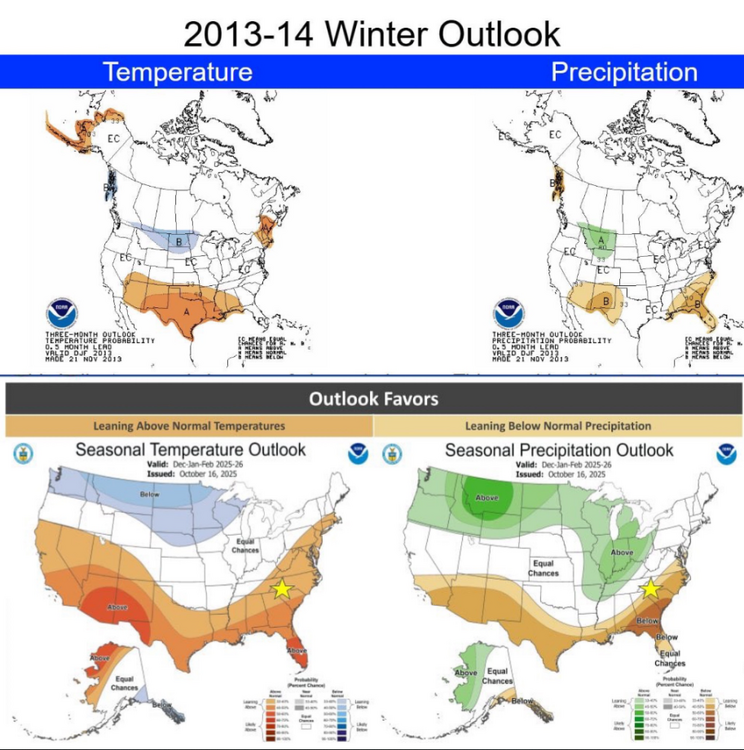
-

Digital Snow/Ice Thread 2025-2026
WinstonSalemArlington replied to WinstonSalemArlington's topic in Southeastern States
-
Thanks. It’s a bit surprising. If the AO is going to be positive, then we should root for a +NAO instead of - Wondering if the SE ridge linkage happens more with a +AO/-NAO regime…
-

Spooky Season (October Disco Thread)
WxWatcher007 replied to Prismshine Productions's topic in New England
I thought slightly AN. Too bullish on the peak, but nailed the big lull and when the tropics would heat up. It was a pretty big comeback but this season never had the runway others did. -
12Z: Icon joining the consensus turning it sharply right as it goes into DR after forming in E Caribbean; also very weak entire run CMC once again is the only model with a TCG E of the Lesser Antilles; TS goes through Windwards; it like the Icon joins the consensus turning it sharply right as it, too, goes N over DR. Then the weakened main part moves NE toward Bermuda GFS forms in E Caribbean and then moves N over PR followed by turn to NE/OTS UKMET text again shows no TCG through day 7 but again a sfc low is there (1007 mb) that’s further S than 0Z with it 300 miles S of Jamaica moving slowly W at 168; so this not turning right by 168 is exception so far of 12Z operationals JMA only out to 72 so far (inconclusive) Euro is next
- Today
-
Because it could abruptly collapse tomorrow.
-
There's definitely a subjective aspect to it, and one author may interpret the slew of objective data sets slightly differently than another. Aside from precip, ground water, river flow, a range of drought indices, and reports from the ground are all used to compile the product. In terms of how it's made, you might check out this short video (first below) and then a much longer and presumably much more detailed video below that (second). I think they'll be instructive in explaining how it all comes together.
-
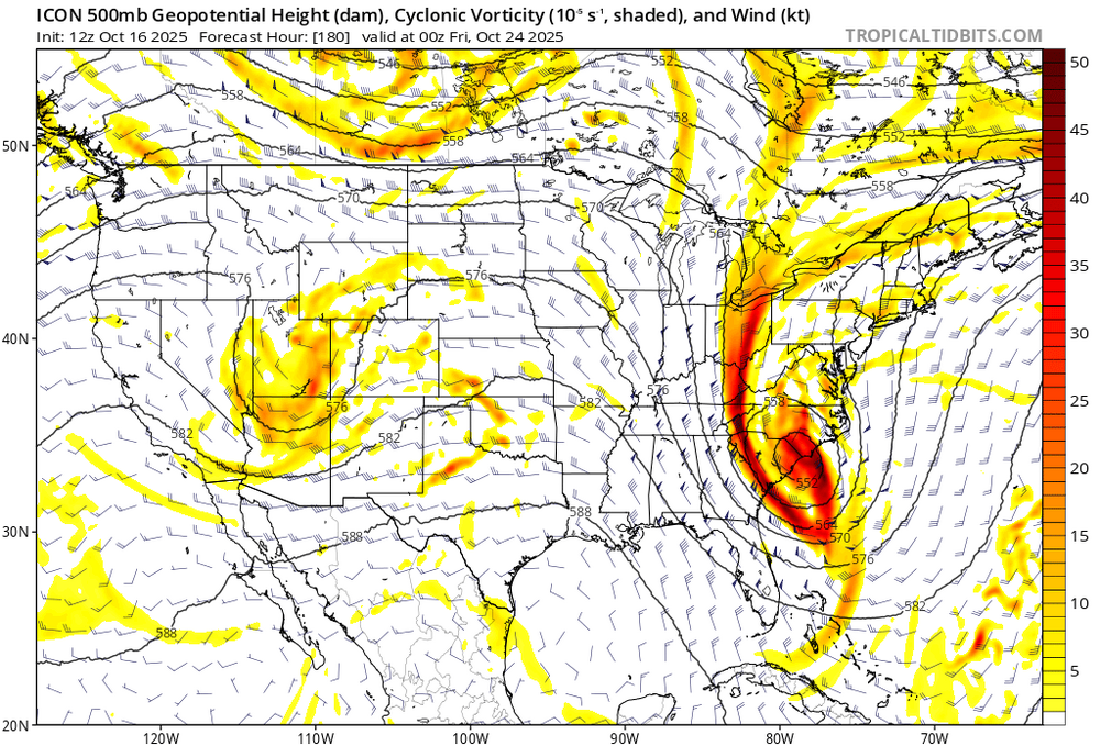
Take with a grain of salt but.... So nice to see a cold front passage then a storm explode in the area. 12z Icon just shows what can happen this winter.
-

Spooky Season (October Disco Thread)
weatherwiz replied to Prismshine Productions's topic in New England
The timing on this has slowed quite a bit. Going to be one heck of a squall going across the region. -

Spooky Season (October Disco Thread)
Chrisrotary12 replied to Prismshine Productions's topic in New England
Going to make my 10a tournament in Dover, NH interesting. -
It has my eye for sure - if a nice low pressure can be in the vicinity - fun things can happen even outside of peak heating. And honestly....I think peak heating becomes a lot less important this time of year and with a dynamic system.
-

Spooky Season (October Disco Thread)
tamarack replied to Prismshine Productions's topic in New England
Maybe some graupel?


