All Activity
- Past hour
-
 DCA: 104 IAD: 101 BWI: 102 RIC: 101
 -
Tomorrow will be the first 90 of the year for DTW. The avg first is June 10th.
-
I’m trying to determine what is the grossest part of the 18z parent NAM run, and I think it is the 108 Heat Index at 8pm on Monday.
-
18z NAM has a seabreeze for Monday as well. But it gets close to 100 before it drops us into the 80s and 70s east of the city.
-
Will be interesting to see the overnight lows. Someone posted in the NYC thread that the Euro had something ridiculous like 92/72 in NYC at 2am Mon night.
-
Happy longest day of the year. I wish tells followed that pattern and not the 2-3 month delay!
-
It will be interesting to see how many 90+ days we actually string together around here. Sat-Mon are a full on lock for 90+, but after that it gets tricky with the ROF potential. The Euro has been consistently keeping the streak alive all week, though, through Friday or so.
-
Tuesday and Wednesday are the days I'm favoring for 100 or better. If we get into the 100s as early as Monday then we're probably looking at a 2012 level heatwave.
-
Forecast high of 98 here on Monday. I'll take the under. 98 is the highest temp I have ever recorded here, and it was once or twice. It will end up 95-96 maybe.
-
i thought that this thread existed already, but apparently it does not. so, here we go...
-
NAM and HRRR are messy with the MCS. HRRR kind of carries activity into SNE through Sunday. That would cancel heat. NAM might argue for clouds. If that clears out in time, Sunday could be quite oppressive in the aftn. Some signs we have deep dews aloft with one of those setups that do not mix out much. Otherwise could be one of those mostly cloudy 85-90 days.
-
Yeah agree with Brian. Probably a lot of 98-99 with some spot 100s. Only thing that mighty argue for a 101 is that per GFS...we mix deeply and dews mix out. That might help offset the 850 Ts.
-
Nice and cloudy out there.
-
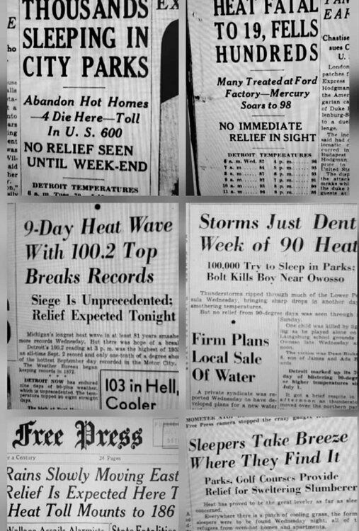
Heatwaves were just brutal in the 1930s-50s...with no AC
-

Occasional Thoughts on Climate Change
LibertyBell replied to donsutherland1's topic in Climate Change
but here in the northeast our air has become more humid and more cloudy, I compare years like 1944, 1948, 1949, 1953, 1955, 1966, when it was far easier to hit 100+ in drier air than it is now. Our cloudiness has increased since that earlier, much drier era. -
a couple of beaches on Long Island are closed because of elevated bacteria levels thanks to excessive rainfall and runoff from hazardous chemicals....
-
 but consider that forecasters do not like egg on their face so to speak... none of us like to be wrong. In this case confidence is high that problems will develop of the magnitude described. Yes watch is less confident than warning,
 -
Really quite extensive tree damage in takoma park. Some big ones down.
-

2025 Spring/Summer Mountain Thread
Met1985 replied to Maggie Valley Steve's topic in Southeastern States
An awesome summer day today. My high today was 75 degrees. It's going to get warm but it's summer. Nothing new -
Busy w granddaughter but I think terminology has changed. UNUSUAL for NWS to issue a watch 3-6 days in advance. Confidence high on problems. In the Deep South they might handle it better?? but here its sudden onset and magnitude. Ensembles continue 100+ for the I95 corridor.
-
So many leaves and twigs ending up in the pool today
-
We got a few bass, pickerel, yellow perch and good size American Eels but never any bullheads. Do you know if it ever produced those?
-
And the sun is breaking back out, just a light shower. Sorta felt (and looks on radar/satellite) like a winter snow flurry/shower. It MIGHT have touched 0.01 in the gauge, I'll check later. Temp 'bottomed out' at 73.0, which is current. More clouds forming out to the W and NW in WV, so it may sprinkle or light shower again later.
-
usually it's 3-4 mows. It's been like 8 mows and they are still growing.