All Activity
- Past hour
-
28 and heavy frost
-
It’s 28 here already. I don’t radiate well…
-
 UHI, which is an important contributor, has been mentioned in several of the past Phoenix-related threads. Even setting aside, UHI, there has been a strong warming trend in Arizona and the Southwest. During 1970-2025, Arizona's minimum temperatures have warmed an average of 0.6°/decade. Phoenix's have increased by 0.8°/decade. In terms of maximum temperatures, Arizona's rate of warming has been 0.7°/decade while Phoenix's has been 0.8°/decade. The differences are a reasonable but not perfect proxy for the impact of UHI. The ongoing March heat is widespread. The following stations with 100-year or longer climate records are on course for their warmest March on record. Some will break their existing records by sizable margins.
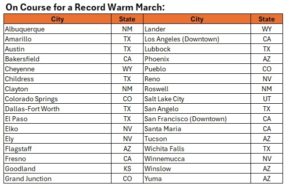
-
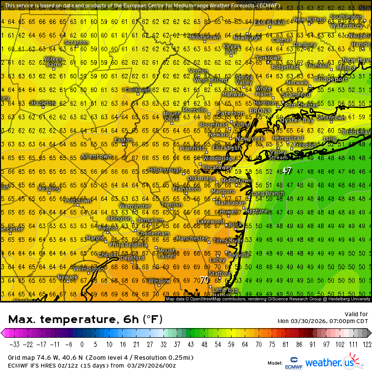
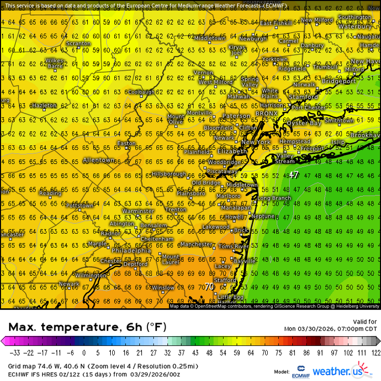
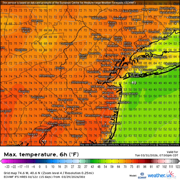
The warm spots like New Brunswick have a chance at another 1-2 March days reaching 70° and could get close to 2012. Time Series Summary for New Brunswick Area, NJ (ThreadEx) - Month of Mar Number of 70° days Click column heading to sort ascending, click again to sort descending. 1 1945 11 0 2 2012 8 0 3 1946 7 0 4 2026 6 3 - 1921 6 0 5 2016 5 0 - 1989 5 0 - 1948 5 0 - 1913 5 1 - 1910 5 2 - 1903 5 0
-
Assy ahead
-
I don’t see the appeal in that. It’s not like we have some vegetation that looks like that. Sticks out like an ugly soar thumb.
-

2026-2027 El Nino
snowman19 replied to Stormchaserchuck1's topic in Weather Forecasting and Discussion
The big WWB has begun to show up on visible satellite -

2026-2027 El Nino
bluewave replied to Stormchaserchuck1's topic in Weather Forecasting and Discussion
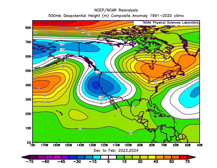
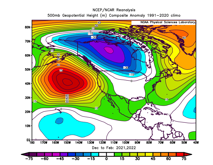
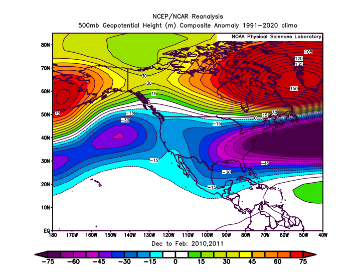
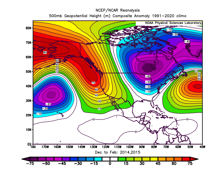
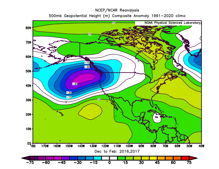
There also seems to be a type of underlying pattern with pairs of winters sharing similar overlapping locations of where their primary ridge and trough locations are found. We can take this back to at least the 09-10 to 10-11 winters. Same story for the 2020s so far. So in a very general sense perhaps the next few winters will find a way to share this similarity also. Obviously, this is all in hindsight and we will need to see how things evolve heading into next winter and beyond. It’s interesting that the models are indicating a potentially robust El Niño development in 26-27 following two winters with strong blocking across the North Pacific into Western North America like we saw following 13-14 and 14-15.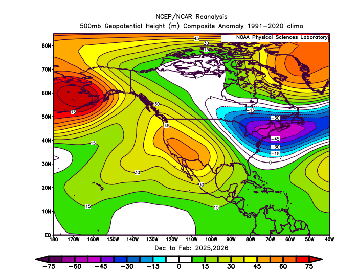
-

Central PA Spring 2026 Discussion/Obs Thread
pawatch replied to Voyager's topic in Upstate New York/Pennsylvania
25 degrees this morning. Slight frost -
Low of 26 with frost. It will probably be 8 months until we are this cold again.
-
It's happening
-
25 here. Looking forward to some warmer weather.
-

Central PA Spring 2026 Discussion/Obs Thread
mahantango#1 replied to Voyager's topic in Upstate New York/Pennsylvania
Now an exorcism should be done to correct the Tamaqua split. -
It gone
-
Hasn't we've had a couple years recently where @powderfreakhit his high temps for the year in April? Lol
- Today
-

2026-2027 El Nino
TheClimateChanger replied to Stormchaserchuck1's topic in Weather Forecasting and Discussion
No, I just meant they are forecasting it as 11th warmest since 1950. I wouldn’t call that “another warm” summer. That’s colder than 5 of the last 6 summers, so I think most here would consider that to be a pretty cool summer. -
22 here as well; back to back cold nights.
-
34 here
-
18F here again. Big warmup incoming though.
-

Central PA Spring 2026 Discussion/Obs Thread
Voyager replied to Voyager's topic in Upstate New York/Pennsylvania
Not sure what happened, but CTP made a major correction overnight. Maybe mahantango's exorcism gif did the trick... Wednesday Night Showers likely and possibly a thunderstorm. Mostly cloudy, with a low around 44. Chance of precipitation is 60%. Thursday A chance of showers. Mostly cloudy, with a high near 55. Chance of precipitation is 50%. Thursday Night Showers likely. Mostly cloudy, with a low around 40. Chance of precipitation is 60%. Friday Showers likely. Cloudy, with a high near 56. Chance of precipitation is 60%. Friday Night Showers likely. Cloudy, with a low around 46. Chance of precipitation is 60%. Saturday A chance of showers. Cloudy, with a high near 61. Chance of precipitation is 50%. -
28 imby w/frost.
-
Central PA Spring 2026 Discussion/Obs Thread
Voyager replied to Voyager's topic in Upstate New York/Pennsylvania
It wasn't the freezing rain that got me, but the cold air and chance of frozen precipitation falling. I'm pretty sure the snow (hopefully anyway) wouldn't accumulate either. I'm not saying I want 75 every day going forward, I'm just sick of the cloudy 40's, and wish we'd not drop below 50 on the cooler days. -
Eff this. 22-23F.
-
22 here this morning.
-
Central PA Spring 2026 Discussion/Obs Thread
mahantango#1 replied to Voyager's topic in Upstate New York/Pennsylvania
Wxrisk.com This current cold shot is probably the last REAL cold blast until late autumn. Now for the obtuse people in the back row you need to read that first sentence again carefully. yes of course between now and June 1 we are going to have cold fronts and cold or cool air masses. Obviously that is the case. What I am talking about in the first sentence are these cold blasts which knock us back down to the 20s at night and 40s to near 50 during the day. . All the data shows there is going to be a significant Ridge in the jet stream (sometimes extremely strong Ridge) that will be situated on the East Coast covering the eastern third of the country between now and April 15th. Any cold wants to come through will be weak and have no will push behind them. THAT BEING SAID REMEMBER SOIL TEMPS STILL HAVE TO WARM !! The old guideline zof waiting until aat least EASTER and preferably tax day...s till holds.