All Activity
- Past hour
-

Possible Light Snowfall (1" - 4") on Tuesday Dec 23
NEG NAO replied to Northof78's topic in New York City Metro
why are you posting a second link blend of models 6 hr snowfall that ends at 12Z 12/24 ? Plus its just not the GFS showing greater amounts -
Clear. 27.2°
-

December 2025 Short/Medium Range Forecast Thread
Golf757075 replied to John1122's topic in Tennessee Valley
I should be more realistic because we only average 4-5 in a winter. Just hope we get close to that -

December 2025 regional war/obs/disco thread
H2Otown_WX replied to Torch Tiger's topic in New England
Meh, I still think this winter has ratter written all over it. No southern stream involvement and the northern stream only cuts when it occasionally amplifies. Everything else is a strung out POS. -

White Christmas Miracle? December 23-24th
Baroclinic Zone replied to Baroclinic Zone's topic in New England
Nothing torks me off more than someone parking in the street in a residential subdivision. Reeks of inadequacies. -

White Christmas Miracle? December 23-24th
SouthCoastMA replied to Baroclinic Zone's topic in New England
assumed you were within the 1" shade. next run will be different anyway -
Don’t forget to remind friends and loved ones this Wednesday that Santa isn’t real. .
-
Windy here too last night. YHZ had a gust to 74mph. Lots of limbs down and 100k without power. Wild storm.
-

White Christmas Miracle? December 23-24th
dendrite replied to Baroclinic Zone's topic in New England
Imagine being a snow and Cowboys fan and having to look at that ugly Giants inflatable and pack when you look out your front window. -
White Christmas Miracle? December 23-24th
dendrite replied to Baroclinic Zone's topic in New England
Wow what a winter. -

Possible Light Snowfall (1" - 4") on Tuesday Dec 23
dmillz25 replied to Northof78's topic in New York City Metro
Let the weenies have this one lol -

Possible Light Snowfall (1" - 4") on Tuesday Dec 23
WeatherGeek2025 replied to Northof78's topic in New York City Metro
i'll tell you one thing that snow Tuesday early am will be heavy with big flakes! if it's below freezing it's going to accumulate! -
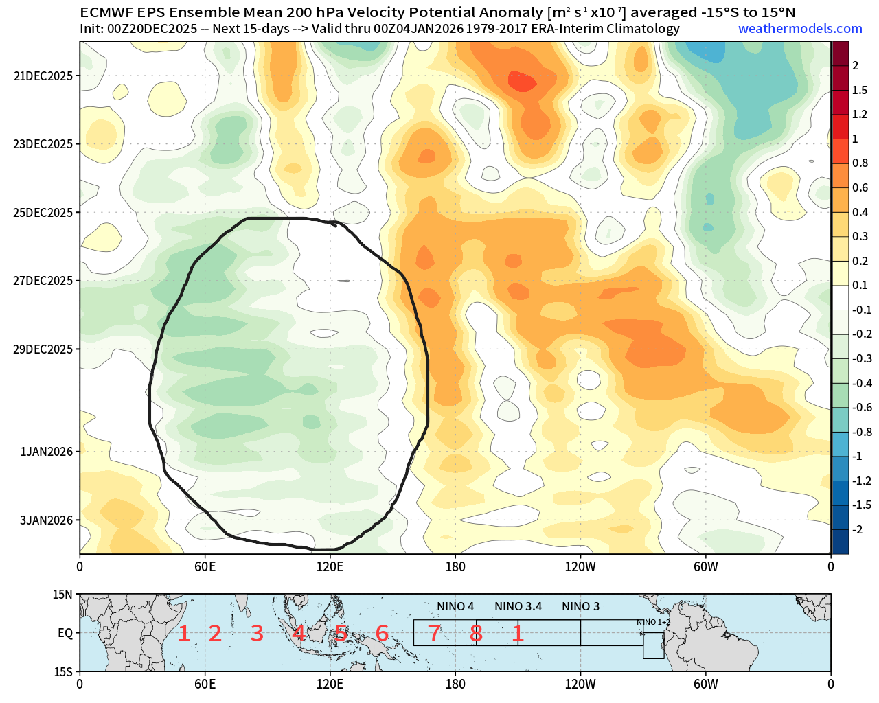
There's a shakeup for the Pacific in the pipeline as we start getting into January. I think this could offer an opportunity for a period of +PNA after the 1st week when these waves break but we'll see. Maybe this ties into Ray's @40/70 Benchmark ideas mid-month so maybe it's part of that timing to transition to +TNH. But I think sometime week 2 we see some changes and maybe clues to that happening during the 1st week of the month. We're being plagued with a series of -EAMT retracting the Pac jet and locking the Pacific block in place on guidance in perpetuity. High pressure into the west of the Himalayas removes the momentum. While high pressure on the east side would add it. This is likely going to change as we start heading into January. An active convective phase looks to cross an Indian Ocean to MC transit to close out December. These set in motion a series of events that eventually leads to +EAMT and a Pacific jet extension. Even at the end of the current EPS 12z I think we can see some signs of a changing Pacific regime. With high pressure building in Siberia in better position and a Jet beginning to be reinvigorated off the coast of Asia.
.png.b9dd45beab83cf14568c4069f83bdbdb.png)

-

White Christmas Miracle? December 23-24th
Damage In Tolland replied to Baroclinic Zone's topic in New England
Even if you hit 38 -40 there with 1-2” it will be white . Low dews . Low sun . We all had 38-44 prior to the screamer and everyone still had pack -

White Christmas Miracle? December 23-24th
Sey-Mour Snow replied to Baroclinic Zone's topic in New England
Your high was 31 today with a dry NW flow... There is potential for upper 30s and low 40s late Tuesday and Wednesday. The GFS is much colder than EURO , let's hope the colder trends continue and that we max out 32-36 instead.. -

Possible Light Snowfall (1" - 4") on Tuesday Dec 23
snowman19 replied to Northof78's topic in New York City Metro
Once again, the GEFS is in total disagreement with its own op, red flag: https://www.pivotalweather.com/model.php?m=gefsens&p=sn10_acc-mean-imp&rh=2025122018&fh=90&r=us_ne&dpdt=&mc=&pwplus=1 NWS Blend of Models: https://www.pivotalweather.com/model.php?m=nbm&p=sn10_acc-mean-imp&rh=2025122018&fh=90&r=us_ne&dpdt=&mc=&pwplus=1 -

December 2025 Short/Medium Range Forecast Thread
Matthew70 replied to John1122's topic in Tennessee Valley
That’s only 3 weeks into winter. Too many people are way to negative & expectations of winter are over the top. -

White Christmas Miracle? December 23-24th
Torch Tiger replied to Baroclinic Zone's topic in New England
Lol -
White Christmas Miracle? December 23-24th
Damage In Tolland replied to Baroclinic Zone's topic in New England
1” of snow will last everywhere.. even coasts . I had 1/4” .. at most 1/2” last night that lasted today. Wet snow and low sun angle FTW . Precisely why you want snow now and not Morch . A day in the 30’s little to nothing melts https://imgur.com/a/dm7YoFS#KIRP4vD -

Texas 2025 Discussion/Observations
Powerball replied to Stx_Thunder's topic in Central/Western States
DFW made it to at least 82*F today, shattering the previous record high of 79*F. -
White Christmas Miracle? December 23-24th
Baroclinic Zone replied to Baroclinic Zone's topic in New England
We watch, we monitor. No need to jump. No negatives in the grand scheme today since this AM. -
Tomorrow will be a bit milder with temperatures returning to the lower 40s with another brief push of somewhat cooler air following for Monday. No exceptionally cold or warm weather appears likely for the first week of astronomical winter. In terms of precipitation, light snow or snow showers are possible on Tuesday. The closing week of December could experience periodic warmer and cooler days. It now appears that the cooler anomalies will persist mainly in central and northern New England. The probability that December 2025 will have a maximum monthly temperature below 60° has increased further. The last time that happened was in 2019 when the monthly high was 58°. If 2025 has a monthly high below 60°, that would be only the fifth such occurrence since 2000 (2003, 2004, 2005, and 2019 are the cases since 2000). The ENSO Region 1+2 anomaly was -0.3°C and the Region 3.4 anomaly was -0.7°C for the week centered around December 10. For the past six weeks, the ENSO Region 1+2 anomaly has averaged -0.33°C and the ENSO Region 3.4 anomaly has averaged -0.67°C. La Niña conditions will likely continue through at least mid-winter. The SOI was +8.15 today. The preliminary Arctic Oscillation (AO) was +1.749 today. Based on sensitivity analysis applied to the latest guidance, there is an implied near 99% probability that New York City will have a cooler than normal December (1991-2020 normal). December will likely finish with a mean temperature near 34.5° (4.6° below normal). Supplemental Information: The projected mean would be 2.9° below the 1981-2010 normal monthly value.
-

Possible Light Snowfall (1" - 4") on Tuesday Dec 23
sussexcountyobs replied to Northof78's topic in New York City Metro
I don't do forecasts. But. Looking at all the forecasts I've seen right now. Looks like a good bet for a coating to 2" for NYC proper. 1-3"/2-4" nw of 287. Currently: clear, calm, 27.9 -
White Christmas Miracle? December 23-24th
Baroclinic Zone replied to Baroclinic Zone's topic in New England

-
It's in Europe. https://charts.ecmwf.int/products/extended-anomaly-2t?base_time=202512200000&projection=opencharts_europe&valid_time=202512290000 Coincidentally, Europe was really cold before we had our cold starting mid-late November, so maybe we live through AN in January while we wait for another chance late Januaryinto February. Just a thought...or prayer.