All Activity
- Past hour
-
Everyone good
-
Put it all on black? No, put it all on p18.
-
I made a post further up in the thread with h5 images showing how imperfect the pattern was leading up to the early Jan 2022 snowstorm, including a SE ridge which became more of a WAR that linked up with a transient -NAO. It snowed a day later. That was the famous 'shit the blinds' pattern with no end in sight, yet I identified a way out and a specific threat window 10 days or so in advance. I got lucky and it actually worked out.
-

January 2026 regional war/obs/disco thread
weatherwiz replied to Baroclinic Zone's topic in New England
Being held by the Statue of Liberty -
What do the median numbers look like? I recall you posting those numbers from pivotal a while back (I believe it's a Pivotal+ exclusive). I'm guessing there's a handful of members who go extreme with the SE ridge and pump big AN anomalies, while the colder scenarios provide pedestrian, yet serviceable cold that does little to revert the mean. Just a guess.
-
p18. Please. Pretty please.
-
<<< == JANUARY DAILY RECORDS for NYC == >>> ... temps in brackets after low min are that day's max when not also a record low max ... ** 2d snowfall was all on previous day ... note that Jan 1 record snowfall was on first day of data records Jan 1 1869 so no indication of 2d total there ... otherwise * all of record 2d snowfall was on that date and none on previous date DATE ___ TEMPERATURES ___________________________________________ PRECIP ________________________________ notes _________ High max ___ high min _____ Low max ___ Low min ________ Max prec ___ Max snow ___ Max 2d snow _ Jan 01 __ 62 1966 ____ 52 1966 _______ 10 1918 ______ -4 1918 ________ 2.05 1888R ___ 9.0 1869 ____ 9.0 1869* (no data prev day) Jan 02 __ 68 1876 __ 49 1890,1911,2023 __10 1918 ___ 2 1918 _________ 1.92 1925RS__11.5 1925 ___13.0 1877 (4.8"+8.2") Jan 03 __ 64 2000 ____ 51 2000 ________ 7 1879 ____ -4 1879 _________ 2.42 1999R ___ 7.0 1923 ____ 8.2 1877** _ 1923 added 2.0 4th Jan 04 __ 66 1950,2023 __ 59 1950 ___ 14 1904,81__-3 1918 _________ 2.73 1982R___ 9.8 2018 ____ 9.8 2018* Jan 05 __ 64 1950,93 _ 53 2007 _______ 13 1884 ____ -4 1904 (14)_____ 1.50 1909R___ 6.5 1881 ____ 9.8 2018** _ 1881 no added snow 4,6 Jan 06 __ 72 2007 ____ 54 2007 _______ 12 1896 ____ -2 1896 _________ 1.57 1962R___ 5.0 1989^____ 6.5 1881** _ 1989 no added snow 5,7 Jan 07 __ 64 2007 ____ 54 1946 _______ 17 1878 _____ 4 2014 (19) ____ 3.12 1874R___13.6 1996 ____13.6 1996* Jan 08 __ 65 1998 ____ 53 2008 _______ 13 1968 _____ 2 1968 _________ 1.25 2007R___ 6.6 1996 ____ 20.2 1996 Jan 09 __ 64 1937,2008_ 50 1937 _______ 14 1968,70__ -1 1968 _________1.73 2024R___ 5.0 1886 _____ 6.9 1996 Jan 10 __ 60 1876 ____ 47 1935 _______ 13 1875 _____-3 1875 _________ 1.80 2016R___ 6.3 1965 ____ 6.3 1965* Jan 11 __ 69 2020 ____ 51 2020 _______ 12 1873 ______3 1968 _________ 1.46 1900R___ 5.7 1991 ____ 7.4 1954 (2.4+5.4) 1991 no added snow Jan 12 __ 68 2020^____47 2017 ________ 8 1886 _____ 2 1886,1968,81 _ 2.35^1915R___6.1 2011 _____ 9.1 2011 Jan 13 __ 68 1932 ____ 56 1932 ________ 8^1912_____-3 1912, 14 ______ 2.35^1915R__11.5 1964 ____ 12.5 1964 Jan 14 __ 70 1932^____55 1932 ___ 17 1893,1988,2004 _-5 1914 ________ 2.06 1940R___ 9.5 1910 ____ 11.5 1964** Jan 15 __ 67 1932 ____ 54 1995 _______ 12 1957 _____ 0 1957 _________ 1.26^1890R___6.0 1892 ____ 10.0 1910 Jan 16 __ 58 1995 ____ 53 1995 _______ 14 1920 _____ 1 1893_2004 ___ 1.44 1924R__ 13,0 1879 ____13.0 1879* Jan 17 __ 63 1990 ____ 46 1990 _______ 12 1977 _____-2 1977 _________ 1.36 1994RS___6.0 1907 ____13.0 1879** Jan 18 __ 66 1973,90 _ 47 1915 _______ 13 1977 _____ 0 1982 (15) _____ 2.10 2015R___ 5.0 1875 _____ 6.0 1907** Jan 19 __ 64 1951 ____ 45 1986 _______ 10 1994 _____-2 1994 __________2.39 1936RS__ 9.0 1936 ___ 9.2 1936 Jan 20 __ 64 1951,2006 _46 1900 _______ 15 1994 _____ 0 1994 _________1.41 1995R __11,1 1978 ______ 13.6 1978 Jan 21 __ 63 2006 ____ 49 1906 ________ 9 1985 _____ -2 1985 _________3.45 1979R___11.0 2014 ____11.1 1978** Jan 22 __ 61 1916,59 __ 47 1906 ________14 1888^_____ 0 1888^_________ 1.26 1891R____ 8.5 2005 ____11.5 2014 Jan 23 __ 63 1874^____50 1906 _______ 11 1871 _____ -3 1936 __________2.55 1998R___27.3 2016^____ 27.5 2016 (13.8 2005) Jan 24 __ 68 1967 ____ 54 1967 ________ 6 1882 _____ -6 1882 _______ 2.18 1979RS __ 7.4 1875,1908_ 27.3 2016** Jan 25 __ 60 1967 ____ 49 2010 ________ 12 1897 ______2 1945 (15) ___ 1.80 1978R ___10.0 1905 ___ 11.0 1905 Jan 26 __ 72 1950^___ 49 1916 ________ 14 1871 ______2 1871 __________ 2.19 1986R ___12.3 2011 ___13.3 2011 Jan 27 __ 69 1916 ____ 53 1916 ________ 14 1888 _____ -1 1927 _________ 1.94 1976R ___ 9.0 1871 ___ 19.0 2011 Jan 28 __ 66 1916 ____ 46 2002,18 _____10 1888 _____ -2 1925 (14) ____ 1.87 1994R ___ 7.5 1897^ ___12.0 1871 (10.3 2004 6.0+4.3) Jan 29 __ 69 2002 ____ 50 2002 ______ 13 1977 ______0 1873 _________ 1.03 1990R ___ 7.3 2022 ___ 8.5 2022 repl 7.5 1897** (6.5 1922) Jan 30 __ 64 2006 ____ 44 1989 ______ 16 1934 _____ -1 1873 (20) ____ 1.19 1939R ___ 5.8 1966 ___ 7.3 2022** repl 6,8 1966 Jan 31 __ 63 1916,47 __ 43 1913 ________ 16 1935,2019 _ -1 1920 _______ 1.51 1914R ___ 8.0 1882 ___ 8.0 1882* - - - - - - - - - - - notable near record values (^) 6th _ 6.0" total snow 5-6 Jan 1893, may be reported as one-day record on 6th in some data sets. Not the 2d max (1881 5th 6.5) 9th _ 2024 rainfall record broke 1.42" R 1936. Total rainfall 1.95" incl 0.22" first few hours of 10th (2024). 57F peak temp. 12th _ 1915 rainfall followed by 1.06" precip on 13th, of which 0.7" snow (so mostly more rain). 12th _ 66 max in 2017 .... 14th _ 66 max in 2005. 13th _ 9F max 1914 22nd _ Probably around -2 F max and -15 F min in 1857 (before NYC records began) ... severe cold lasted 2-3 days 23rd _ 62 max 1906 ... 2.31" prec from the record 27.3" snowfall. 1998 had 2.55" rain. 28th _ 7.1" snow 1943, 8.4" 27-28
-

E PA/NJ/DE Winter 2025-26 Obs/Discussion
RedSky replied to LVblizzard's topic in Philadelphia Region
A neighbour takes them down January first which is insane -
What did the P.I.S.S. Index look like in the 10-15 days leading up to the Jan 2016 event?
-

January 2026 Medium/Long Range Discussion
NorthArlington101 replied to snowfan's topic in Mid Atlantic
Just for you
-
One thing I’ve noted the last couple days is that the end of the op runs haven’t been looking like the ensemble means. This is @mitchnick’s anecdotal rule. Today there’s better similarity with non-GFS runs having a more or less favorable winter pattern for us D10-15.
-

January 2026 regional war/obs/disco thread
Damage In Tolland replied to Baroclinic Zone's topic in New England
Where’s the torch ? -
Snow chances probably aren't very high(although this is literally the only period the model gives us snow). Nor have the chances of snow been high with the better look up top, legit cold in place and zero SE ridge. Its a crapshoot man. I bet we get some snow in the next 15 days, because that's how random this all is, models aren't very reliable at range, and ofc, the WDI!
-

January 2026 regional war/obs/disco thread
40/70 Benchmark replied to Baroclinic Zone's topic in New England
I like early Feb...then flips warm while strat does it's thing. -
January 2026 regional war/obs/disco thread
40/70 Benchmark replied to Baroclinic Zone's topic in New England
Theoretically speaking, I agree....but I would be stunned if ends up solidly negative. -

January 2026 regional war/obs/disco thread
weathafella replied to Baroclinic Zone's topic in New England
Lol….a big whoosh! -
From the SE forum, Euro heading in the right direction.
-
12z euro. It's in the mid to long range and we've seen what the points look like but this is kind of what we want. Sent from my SM-G998U using Tapatalk
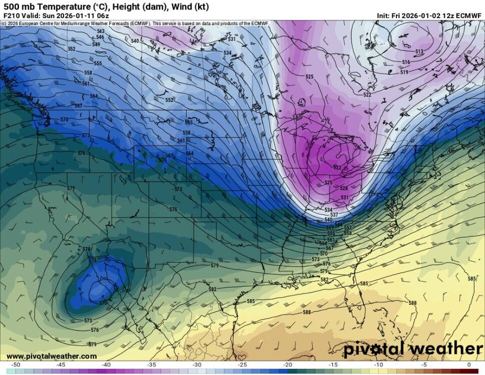
.thumb.jpg.fe440d2e4ac6dc5661e4519ef7f5ffa2.jpg)
.thumb.jpg.d347ac395ec06a728afaa3776177c3a8.jpg)
.thumb.jpg.3af67a2a2465562810457aa3fa22cd95.jpg)
-

January 2026 regional war/obs/disco thread
WinterWolf replied to Baroclinic Zone's topic in New England
That’s basically a 4 week window…and at peak climo for SNE that Cosgrove is predicting. He didn’t do too well last year with his ideas if I remember correctly? Or maybe I’m mistaken? -
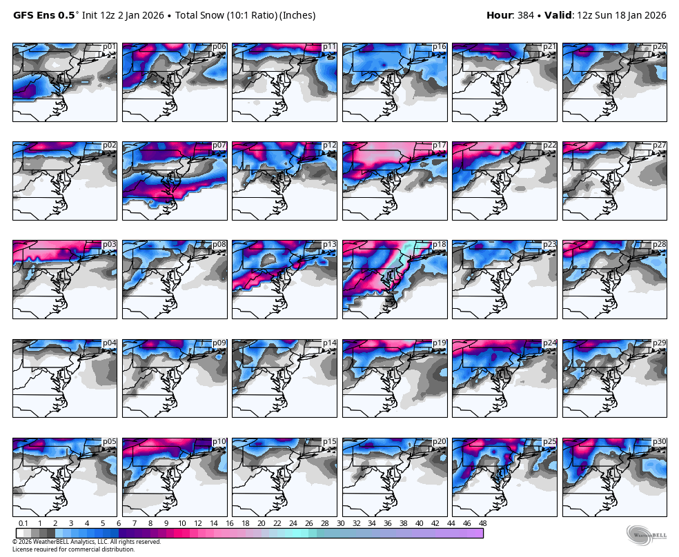
Someone with panels wanna find the big dog in the GEFS for Jan 16-17? Quite an influence on the average I imagine edit: can see it in the mean mslp with members lol. Looks like it even tucks a bit. 1004 at OBX, 996 just off Ocean City, then 989 off central NJ
-
Whatever, I'm reasonably confident we can get cold air by the latter half of the month. My top analogue is.....1985. I was only 4yo that winter living in Michigan so I have.no idea what it brought here. What I'm not reasonably confident is precip. The drought presses on for the next few weeks and I see no reason it lets up this month.
-
What I think would be fascinating is if someone developed a "Pattern Incoming Surety System" (PISS) Index to describe the certainty level associated with the 2 week pattern forecast. A variety of factors would go in the creation of PISS. How many ensembles are in support? What's the spread? Did it just pop up for a couple of model cycles, or hace the runs been dripping in and steadily increasing the flow of confidence as we approach? Less important, but still crucial: how do the higher res mesos compare to the short term ensemble depiction (kind of an initial conditions test). A 5 alarm PISS Index reading would be something like we saw in I believe January of 2016. Amazing pattern trending to locked in storm 10 days out. Sent from my SM-S938U using Tapatalk
-
Oh yeah yall can get hammered with a Miller A. It will ge nice when that pattern sets back in.
-
You damn right I do. Im an optimist even when the pattern is crappy. Seen it too many times. The pattern is volatile and honestly it's been like that for most of the season. No reason for that to change now. I hope your right about after the 10th. Many ensembles look to build the EPO ridge out west after that time period but as we've seen the ridge out west collapses...
-
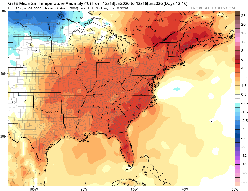
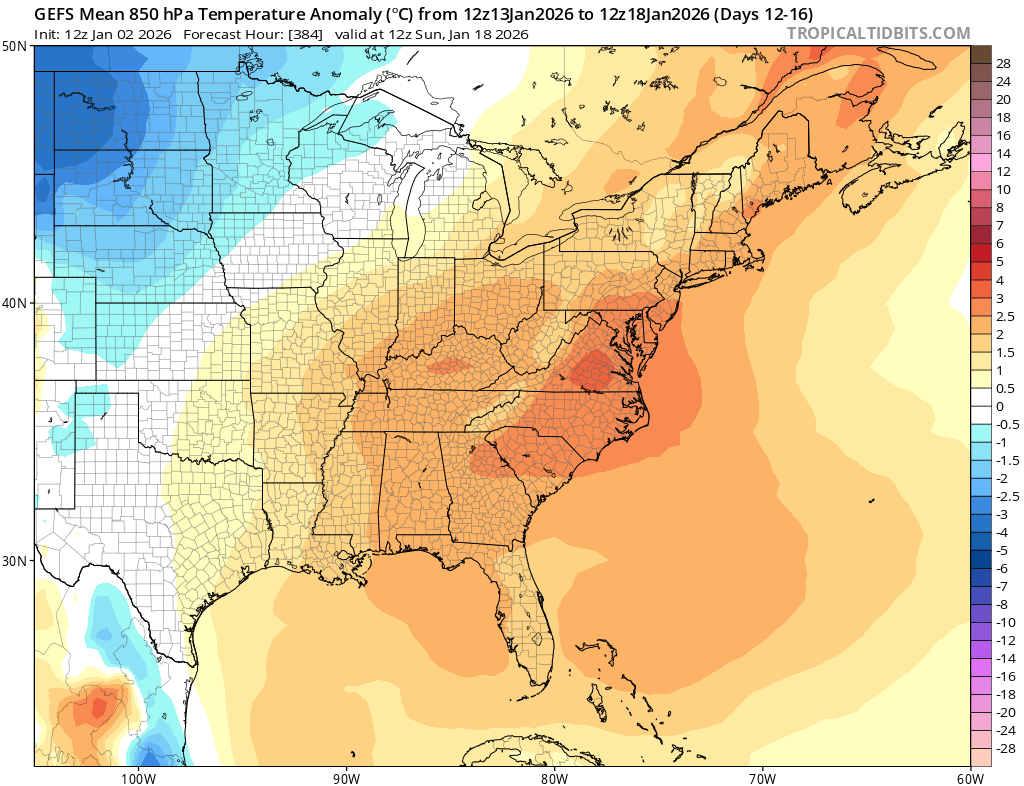
Going to have to disagree with you on this one. First, I'm discussing the run verbatim. You used the 11-16 day average, so will I. Surface and 850 are decently AN verbatim. I don't believe the chances of snow are high at all.


.jpg.a800ed741693447ad14a66c8cad86051.jpg)
.jpg.a95906e66ba4824a2a2bbd23317ef994.jpg)
.jpg.c3ba2de998b768de099f303a26bfdb11.jpg)