All Activity
- Past hour
-
BOS with 90° today
-
Triple IPA
-
Very warm conditions will likely continue through tomorrow. Showers and thundershowers are possible tomorrow as a cold front moves across the region. Some of the thunderstorms could be strong or severe. Cooler weather will return for at least the first half of next week. The ENSO Region 1+2 anomaly was +2.6°C and the Region 3.4 anomaly was +1.3°C for the week centered around June 3. For the past six weeks, the ENSO Region 1+2 anomaly has averaged +1.95°C and the ENSO Region 3.4 anomaly has averaged +0.98°C. The ongoing El Niño will continue to strengthen through the summer. The SOI was -30.44 today. The preliminary Arctic Oscillation (AO) was -0.344 today. Based on sensitivity analysis applied to the latest guidance, there is an implied near 77% probability that New York City will have a warmer than normal June (1991-2020 normal). June will likely finish with a mean temperature near 74.4 (2.4° above normal). That would make June 2026 the eighth warmest June on record. Supplemental Information: The projected mean would be 3.0° above the 1981-2010 normal monthly value.
-
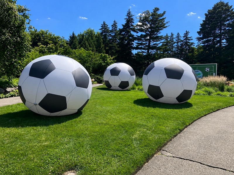
Four photos from the New York Botanical Garden during a warm June day.


-
Beer?
-
.thumb.jpg.6a4895b2a43f87359e4e7d04a6fa0d14.jpg)
Central PA Summer 2026 Discussion/Obs Thread
Yardstickgozinya replied to Voyager's topic in Upstate New York/Pennsylvania
Not that anybody probably cares, but I got so far behind in work and life I decided to drop the forum for a while and until I got caught up. -
Did Wiz hijack your account? Triple this:
-
Central PA Summer 2026 Discussion/Obs Thread
Yardstickgozinya replied to Voyager's topic in Upstate New York/Pennsylvania
There are some questions about tomorrow's setup, the big one, being the possible lack of instability. What started off looking like could be an anomalous storm season for cpa fell off a cliff quick. Instability and weak capping has been about as hard to come by the spring, as any of i've seen. That said, we all know big shifts are taking place right now so let's see what happens. Seems like we're moving in the right direction for increased convection opportunities and most importantly precipitation. -
I made a series of posts regarding the Winter, and things to watch out for later this year, in the Mid-Atlantic forum, starting here:
-

2026-2027 Super El Nino
Stormchaserchuck1 replied to Stormchaserchuck1's topic in Weather Forecasting and Discussion
Subsurface is warming again. Eastern subsurface is about to pop a +8c on TAO/Triton. If normal water is 65F, that's almost 80 degrees, 100 meters below the surface. In La nina it can possibly cool down to 55F, so it must be interesting the type of wildlife that has evolved there, along the equator. -
101 at 4:26pm. Had about 5 raindrops hit my car driving past the State Fairgrounds.
-
Tomorrow night is a little intriguing. Could be some triple point convection moving through.
-
77* and a great breeze. June FTW.
-
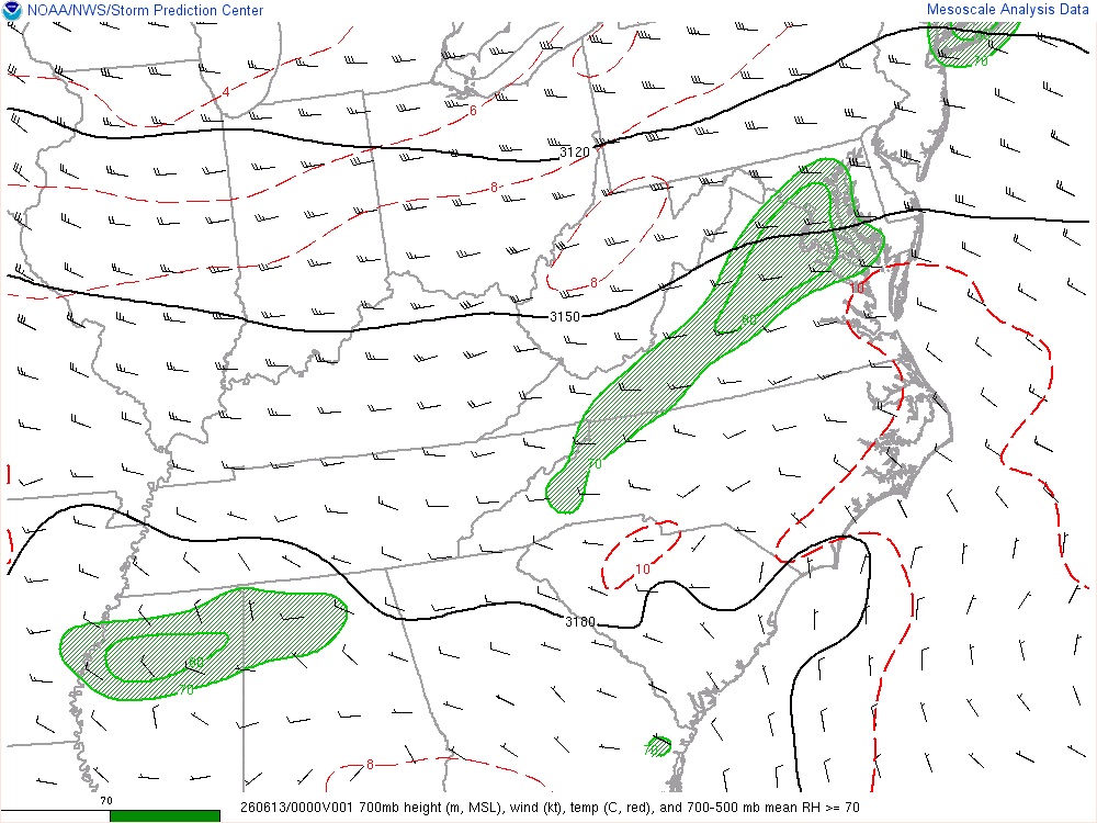
SPC Hourly Mesoscale Analysis - Archive Viewer. You can loop this and see what I mentioned above.
-
Nothing like a good cold front to knock the temps down
-
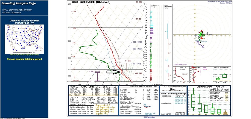
...perhaps a "LID" was probably partly to blame----Nothing really strong enough to break it in past I-77? Used the sounding from GSO 00Z, since any convection was to be around that time frame across central NC. Relative humidity levels between 500 and 700 relatively low, evident on sounding, but maybe part of why little convection took place over the central NC. Always pieces to a puzzle. Just my thoughts.
-
High of 90F at DCA, 12th of the year thus far.
-
Of course.
- Today
-
It felt that way then the sun broke containment, 98.1
-

2026-2027 Super El Nino
jaxjagman replied to Stormchaserchuck1's topic in Weather Forecasting and Discussion
Im kinda skeptic you see any big change in the SST'S in the east.Seems like we are fixing to see a WWB getting combatted with possibly a strong EWB,which is why you see the RMMS showing a decent signal into the WP when we get into July and beyond,other than that maybe a ERW off the Peruvian coast which could possibly warm 3 up,should not be much going on well into July -
Now this is summer. 86/55
-
best chance of severe yes. But we do have great dynamics and potent shortwave moving through with strong height falls so I think precip. will be expansive. What kills our severe potential with this is the lack of steeper mid-level lapse rates and/or stronger cooling aloft. Having those present would yield stronger instability, despite the loss of heating. We will destabilize though after sunset just from increasing dewpoints though but don't think it will be enough to maintain svr potential outside of super localized
-

2026-2027 Super El Nino
roardog replied to Stormchaserchuck1's topic in Weather Forecasting and Discussion
That seems like a huge change. If they changed their methodology that much then it's hard to take the past numbers seriously. It's almost annoying actually. lol -
Subtle changes for 18z lol
-

Junorch obs and discussion 2026
Damage In Tolland replied to Damage In Tolland's topic in New England
Seems like NYC south and CNE/ NNE. Just scattered at best SNE


