All Activity
- Past hour
-
I hate sleet this past October
-
We are on NYC this weekend so of course it will rain.
-
We also need a respectable 500 mb pattern. Looks like the "best" climo is one that features a ridge flexing NW -> SE from Kentucky to Bermuda. Kinda of laying the train tracks for us.
- 1,007 replies
-
- severe
- thunderstorms
-
(and 2 more)
Tagged with:
-
yeah we had the same issue last week for our upstairs unit....was fixed Sat but then it cooled off lol
-
Anyone heading to OC MD this weekend for the Air Show? I'll be there and am hoping to squeak out decent weather for later Saturday and Sunday, sounds like chance of showers and cloudy right now.
-
-
My AC broke yesterday, at least it will be a cool weekend!
-
While I was waiting to undergo pre-op tests, I watched nurses helping a surgery patient practicing on stairs, almost certainly on the day after his operation. I anticipate going thru the same, as there's 8 steps to enter our place - fortunately has rails on both sides. Hazy sun here, will be cooler than yesterday's 74.
-
That might be a good pattern to get MCS or derechos to track through from the Midwest. Looks like a ring of fire type pattern.
-
Dewpoints are currently at nice levels, we take
-
It's all good. The winter lovers have been shortchanged the past few years. Guess it's my turn.
-
About 5 years ago during this period, I ken 5 or more days of clear sunny skies in a row; unheard of even during summer months here. Not even 2012 had that kind of streak I'm aware of. We had a couple good days, now back to grunge.
-
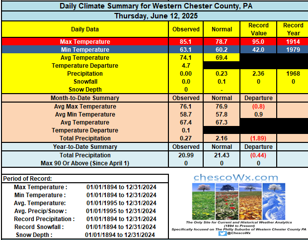
A pretty nice day on tap across the area before shower chances begin to increase late tonight. Of course, the weekend looks have some rain at times. Although, not a complete wash out with the best chances of rain late tonight through Sunday morning. Rain chances to lessen by Monday night but ramp up again by midweek. Does anyone remember those drought concerns?
-

E PA/NJ/DE Summer 2025 Obs/Discussion
ChescoWx replied to Hurricane Agnes's topic in Philadelphia Region
A pretty nice day on tap across the area before shower chances begin to increase late tonight. Of course, the weekend looks have some rain at times. Although, not a complete wash out with the best chances of rain late tonight through Sunday morning. Rain chances to lessen by Monday night but ramp up again by midweek. Does anyone remember those drought concerns? -
Going to be a long crappy Father's Day weekend for many
-
one day we will get a power grid collapsing derecho followed by two weeks of 90+
-
i just want the snow bunnies to suffer
-
We have deep summer well into October.
-
And the most humid month awaits!
-

Central PA Summer 2025
Mount Joy Snowman replied to Voyager's topic in Upstate New York/Pennsylvania
Low of 69. Boat day. -
I'm about 5 miles inland here...90 degree days are actually somewhat rare compared to nearby places like Danbury White Plains or Newark given the seabreeze
-
From watching this tool this spring so far - it seems like it way overdoes things - I'm not even sure it works on the same percentages as SPC...so take those maps with a grain (or a handful) of salt. I've been using it more of a "first look" at which days to look at closer.
- 1,007 replies
-
- 1
-

-
- severe
- thunderstorms
-
(and 2 more)
Tagged with:
-
45%... impressive indeed
- 1,007 replies
-
- severe
- thunderstorms
-
(and 2 more)
Tagged with:
-
Saturday looks like shite, maybe Sunday can be somewhat salvaged - But we can do a lot better on Father's Day.
- Today
-
i actually suggest it is useful to do that - not just a bias evidence. i was just smirking that we've been low-balling if not failing heat since last november really. i've actually been seeing evidence of winter 'structure' to the super synoptic behavior, just doing so at 30 to 40 dm higher. weirdly long wave lengths and useful pna prognostics is not very summer like, so we get what we get from that. try to spare the long winded digression ( no pun intended) but the fast flow associated with blazing equatorial and sub-equatorial heights would be the most suspect factor in keeping the jet alive due to +d(gz) at mid and upper latitudes... anyway, in deference to that being the case ... i believe these odd-ball cold lobes in ontario like these long range gfs have some principle value to them. i mean they're not going to be right per se, just in concept in other words. that's an important heat signal in that ~19th + time range out there but we'll see.


