All Activity
- Past hour
-
Yeah, that looks ideal for STJ and Gulf Action on up through Hattras as you said. Man, providing there's enough cold and the STJ is active enough that would be great.
-
Perfect BLUF.
-
Still snowing
-
12z Euro active with multiple chances. I like it.
-

December 2025 regional war/obs/disco thread
Damage In Tolland replied to Torch Tiger's topic in New England
We had a very localized icestorm here two winters ago where literally the two hilltops in town near or over 1k had under .50 accretion but the next morning big winds hit with 50-60mph gusts and all hell broke loose. The rest of the town had zero ice. Every house in the neighborhood lost at least one tree or had large limbs down, of course I was in heaven but that’s how I’m programmed . Big winds of thickly iced trees is wild . https://imgur.com/a/zQzYoDx#7PlJaSM https://imgur.com/a/zQzYoDx#mbAc3Hu https://imgur.com/a/zQzYoDx#WFHuic1 https://imgur.com/a/zQzYoDx#oVK4yun https://imgur.com/a/zQzYoDx#OTESvFN -

December 2025 regional war/obs/disco thread
ma blizzard replied to Torch Tiger's topic in New England
not enough QPF for ice storm warnings and we aren’t advecting in colder temps / lower dews so its more of an in situ icing with a slow climb to 32 sure it will be icy in NNE but think it will fall short of being that destructive -
we are so back
-
Yeah, been thinking about how close that is to happening and it causing me anguish to see how a couple little Flies keep hampering it from evolving on Modeling, lol
-
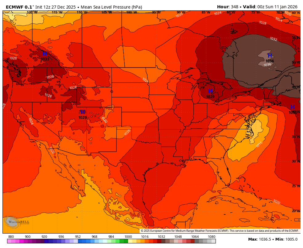
lol us analyzing a 348 hour map. We definitely are in the shut the blinds window right now
-
Kind of a yin and yang look. But if I showed you this....not a bad look. When I toggled to a 5 day 500 pattern, this is what I got. Kind of like putting it in the blender and washing out the craziness. That will work, and it is cold. That storm signal is almost perfect with the low inside Hatteras.
-

Wounded Duck Strikes Back: Dec 26 & 27th Winter Storm Obs
weathafella replied to WxWatcher007's topic in New England
The one thing that was a bit surprising was the fact that once radar echoes reached me it started snowing at a good rate. I thought I’d be fighting dry air but that seemed to be displaced 20-30 miles further north. -
We do wind well in the mid-Atlantic Extreme Western Allegany-Western Garrett-Eastern Garrett-Western Grant-Western Mineral-Western Pendleton- 1144 AM EST Sat Dec 27 2025 ...HIGH WIND WATCH IN EFFECT FROM MONDAY MORNING THROUGH TUESDAY AFTERNOON... * WHAT...West winds 25 to 35 mph with gusts up to 55 to 65 mph possible, with the highest gusts near the ridgetops. * WHERE...In Maryland, Eastern Garrett, Extreme Western Allegany, and Western Garrett Counties. In West Virginia, Western Grant, Western Mineral, and Western Pendleton Counties. * WHEN...From Monday morning through Tuesday afternoon. * IMPACTS...Damaging winds could blow down trees and power lines. Widespread power outages are possible. Travel could be difficult, especially for high profile vehicles.
-
Look what's in the Great Lakes.
.thumb.png.c0587caab00bcde851f37ffab60ac7ab.png)
-
Only so many winters left for us right...ain't nobody got time to wait
-
Close but no cigar
.thumb.png.8f322d3510610816865e2af0048b95c6.png)
-
Banana High, peak climo, cold Canada and the outcome still sucks. Yes its at OP at 348 hours, LOL.
-
Doesn't look so mixy out this way
-

Winter 2025-26 Medium/Long Range Discussion
Baum replied to michsnowfreak's topic in Lakes/Ohio Valley
Never concerned. -
surprised you pointed to the high without mentioning the fact that it's the middle of january as well lol
-
Perfectly said and exactly what the deal is imo brother!
-
Come on. End of run storms are a dime a dozen and I can't think of one that's ever worked out. Too many things to go wrong Until we get a confirmation by the operationals and ensembles, all we have is potential. Big deal.
-
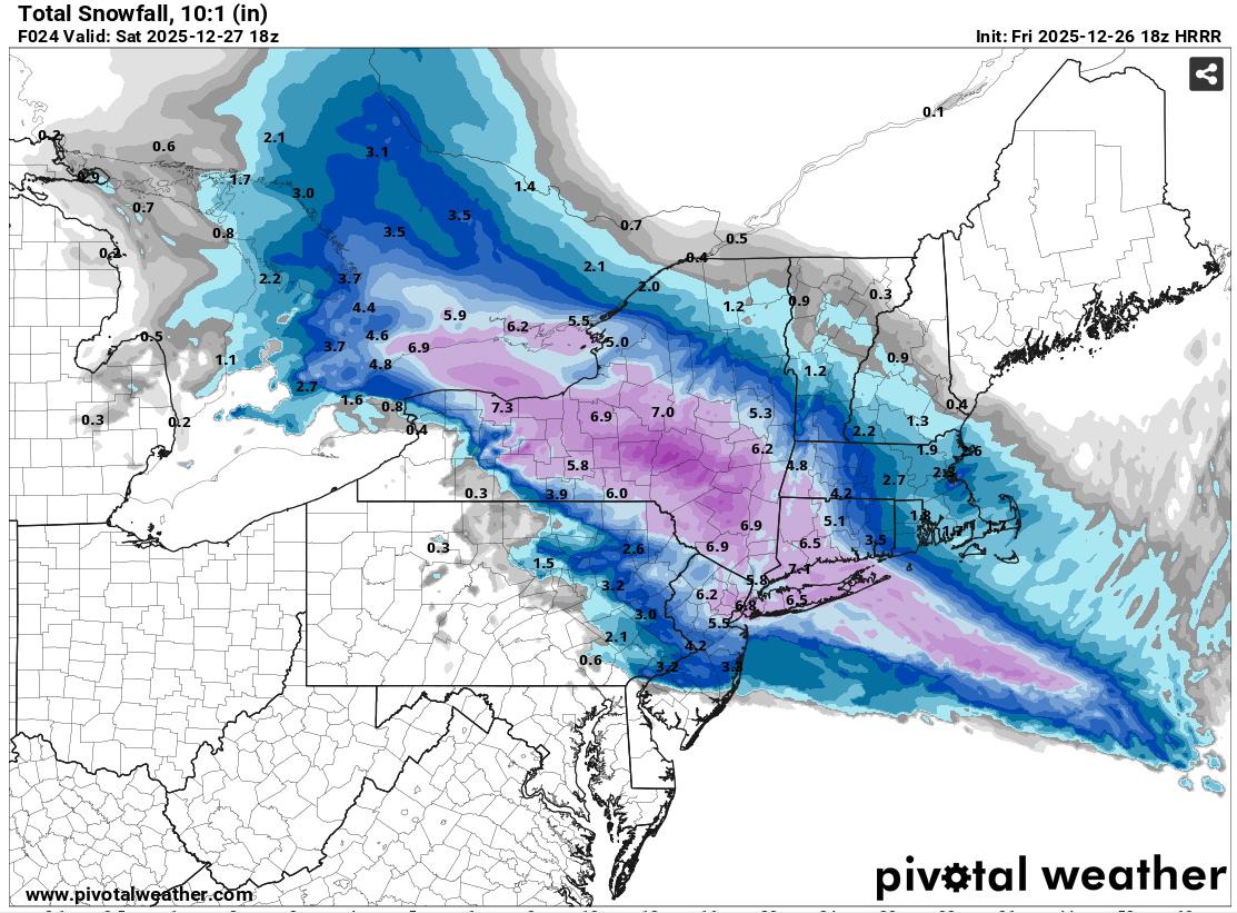
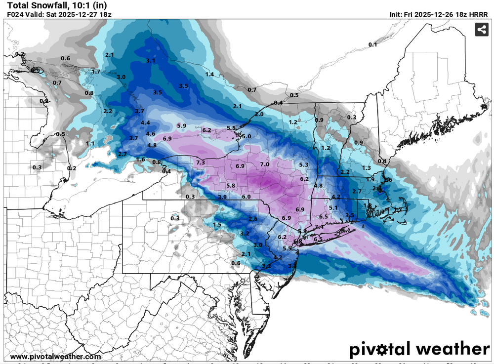
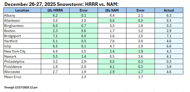
As forecasting accuracy requires, among other things, an objective assessment of the guidance, I've expanded the comparison of the 12/26 18z NAM and 12/26 18z HRRR. The major point of contention had been whether the NAM was providing a realistic forecast for the New York City area. It did not fare well. But what over a larger area? Again, the HRRR outperformed the NAM, but its forecasting edge was less decisive. The HRRR was better in assessing where the 4" or above snows would fall from New York City southward. The NAM confined such snows to the north and east of New York City. However, the HRRR was too aggressive in pushing 2"+ snows past Allentown and into Philadelphia. The HRRR also did better in such locations as Albany and Boston. 12/26 18z NAM: 12/26 18z HRRR: Outcomes for 12 Cities:
-
exactly - it had the storm many days in advance but to be fair other models did not pick up on that warm layer surging north so early in the storm - so GFS not alone screwing it up
-
if we are getting mixing with a1036 high in this position....just cancel winter now forever

-
You can see the pattern evolve to coastals on the Euro. I suspect what we see is some sort of TPV get trapped under an EPO/NAO block which bridges across. I just think modeling isn't quite there yet. Models are so very close at 12z. I think we keep the cold...but again, January seasonal will get it done.


.png.e85d64652ff90fec3cf7106f1c3b7229.png)


.png.f6679933be4182beba63351a7e198398.png)