All Activity
- Past hour
-
Spooky Season (October Disco Thread)
Great Snow 1717 replied to Prismshine Productions's topic in New England
you are wishing for that lol... -

Spooky Season (October Disco Thread)
CoastalWx replied to Prismshine Productions's topic in New England
Could be Mowvember to start? -
Well hopefully this is our last warm spell. I've been off the board for a while, but all is well. With tropical cyclones staying offshore it allows warmth through the middle of the week. Still might get some Mountain t-storms. I'm hoping for some Tropical high clouds Monday evening to set up a gorgeous sunset but that might be only a Carolina thing. Looks like some new members, or back after a while. Woo-hoo! Welcome @midwoodianand @louise.caison233to the best Region on the Forum. Yeah Signal Mountain forecasting is a whole other animal. Slips under the model radar, yet big enough to make an impact. Then there's the ol' 2 inches of snow on Signal with lovely brown ground in the Valley! Somebody asked me about fall foliage, about which I have no clue but somehow I always make a guess. My thinking is the August rain saved southeast Tennessee from a dull autumn. Northeast Tennessee seems to find a way no matter what. Elsewhere might have drought stress from July and August. Recent dry is less of an issue since trees start to go to sleep even while they're still green in Sept. However it goes the other way; recent Sept. rain might not help much. We'll see. Fall foliage is like a box of chocolates!
-

2025-2026 ENSO
40/70 Benchmark replied to 40/70 Benchmark's topic in Weather Forecasting and Discussion
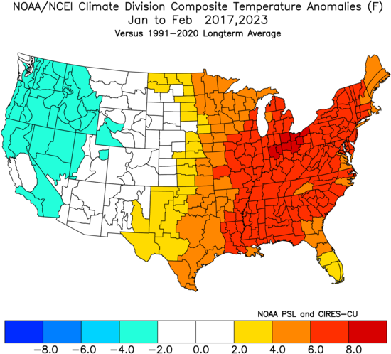
I think January will turn markedly colder in the second half, but cold probably out weighted by warmth, especially east. -
Was not expecting it to look so symmetrical today. Very impressive loop and very clear it is getting its act together quickly
-
Last thing I’ll say right now- track guidance is now tightly clustered on a solution that gives Bermuda direct impacts if not a rare landfall. This is not a “fish” storm and may actually be chaseable in Bermuda
-
Nice visible loop.....on her way to Cat 2. I'd venture to say Imelda reaches Hurricane status by 5pm based on radar and satellite over the past few hours. https://www.meteo.psu.edu/ewall/PSUGOES_MESO1/loop90.html
-
Wow, Melbourne radar shows a very well defined system with a partial eyewall. Continued strengthening is expected based on that look
-
Fall 2025 Medium/Long Range Discussion
A-L-E-K replied to Chicago Storm's topic in Lakes/Ohio Valley
Looks like a torch month, would love to pop a 90 -
Up to 60 mph at 11 am and now forecast to reach cat 2
-
2025-2026 ENSO
PhiEaglesfan712 replied to 40/70 Benchmark's topic in Weather Forecasting and Discussion
With this being a -ENSO and strong -IOD, there is a much higher than normal potential for a very warm January. That's what happened the last 2 times we had that combination, and it continued into February. December is probably the best chance for snow and cold this winter, although 16-17 was saved by a snowstorm in mid-March. But it seems like the winters are ending earlier post-2020, and you can't count on a snowstorm anymore. Heck, snow seems hard to come by since the end of the mid-2010s el nino. -
I guess we are doing June in October again. This could be forecast for the week of Father's Day or the 4th. Not so much for October 1st. At least the days are nice though. Just to think, we have the same daylight as ~March 10th rn, where we can have a foot of snow on the ground and 20 degree highs.
-
Spooky Season (October Disco Thread)
Great Snow 1717 replied to Prismshine Productions's topic in New England
even into the first month of winter(November) ??? -
They were +15 on the high and only +11 on the min
-
Looks like some prime biking and hiking weather coming up. Every now and then I hit up Weverton for a quick hike.
-
BOS put up a +13.3 yesterday, driven by the high low temps. Now at +0.4F MTD ORH is at +1.6F MTD
-
Quit whining like a child
-
I'd add to this discussion that these indices are also increasingly non-resonant. Meaning, they are less (apparently...) physically forced into quasi-stable mode. The reason for that is related to the increased winter time gradient in the whole sale integral of the subtropical to Ferril latitude band. Faster basal flow velocities sends the Roulette wheel spinning more frequently - metaphor.
-
That lower sun angle parboiled me as I drove to BGR and back, especially the return trip at 2:30-4 PM. The car's failed A/C added to the oppressive effect, even with temps near 80 rather than 90s.
-

2025-2026 ENSO
40/70 Benchmark replied to 40/70 Benchmark's topic in Weather Forecasting and Discussion
Stratospheric Reflection events, which are triggered by Pacific trough regimes, trigger a transition to AK ridging and colder patterns across the CONUS. They are more common in +QBO seasons (30/44 since 1980), which is maybe what snowman was getting at....but I am going against the grain a bit in feeling as though we get one due to the prevlence of them in my analogs. Usually very warm a few days prior to a few days after the start, but it begins turning colder quickly....so I guess you could say mid January warmth. Early to mid-January, anyway. - Today
-
Thank you for making this fun table for 14 years. I doubt that many knew how much work and $$ it took to keep it working. May you have a low-stress winter with some big 'uns.
-
Occasional Thoughts on Climate Change
Typhoon Tip replied to donsutherland1's topic in Climate Change
You have to consider the total geology of Earth in the model/differences comparing the two oceanic basins. The NE Pacific arc is blocked off from the arctic by Alaska and the continental rise - identified by Aleutian archipelago of islands. The arctic waters are prevented from intermingling. Additionally, the NW Pacific blocks the arctic due to NE Siberia. There is a gap between, but it is very shallow - the Bering Straight. In fact, ...over the last ice advance cycle of the greater Pleistocene epoch, it is theorized that the ocean levels, having fallen crucial distance, exposed a 'land bridge' that assisted animal migrations between Asia and North America. Many ancient native America human populations are believed to have arrived via the land bridge route during these lower oceanic level time spans.. Anyway, that sub-surface geology blocks the Pacific from establishing an "AMOC" of its own. Compared to the N Atlantic Basin, where deep oceanic floor abruptly abuts the Greenland landmass. Very cold water due to intermingling with the Arctic happens there, where it really can't happen in the far N Pacific Basin. The cold water is heavy ... it falls to the bottom of the ocean - organized in 'chimneys', these tubes of very cold water plummet to the ocean floor. The falling motion pulls the surface water into replace, due to conservation of mass; and since their is less obstacle to fluid flow, S, that encourages a surface motion that is preferential from the Equator toward the N. The ongoing pattern of wind stress and Coriolis then organizes the large scaled anti-cyclonic motion of the Basin. The Gulf Stream and the Japan currents of either Basin are artifacts of the same wind stressing and Coriolis balancing, but the Atlantic has this AMOC machinery that the Pacific does not. Because of all this... the Pacific distribution of upper oceanic heat content is shallower, thus .. can be thermally modulated faster. Might be a little counter-intuitive when knowing that the Pacific is larger than the Atlantic by a several factors of total mass and surface area, but AMOC has a vastly deeper Z-coordinate in the total integral. -
https://x.com/bam_weather/status/1972640087235232099?s=46 .
-
DocATL started following Fall 2025 Banter Thread
-
Yup...that's a nice shot of colder air modeled.


