All Activity
- Past hour
-
83 ... 35 delta
-
-
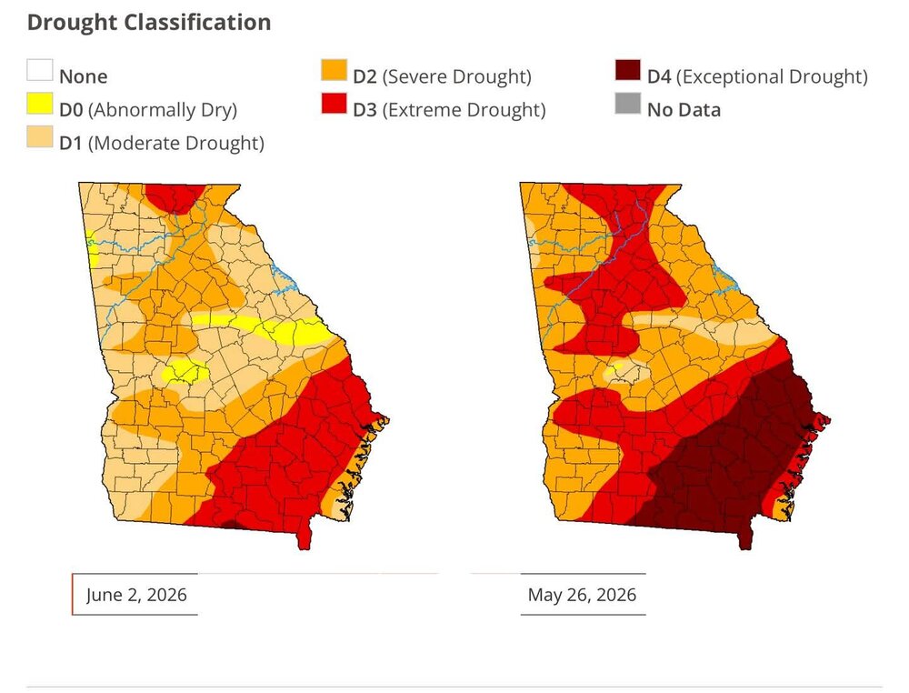
Hit a bone chilling 54 this morning. Crisp is an understatement. Beautiful couple of days. Here's an updated drought map. Much improved for most of Georgia, except close to the coast unfortunately.
-
Really wish summer was 6 months long. It literally took until June to have extended awesome weather.
-
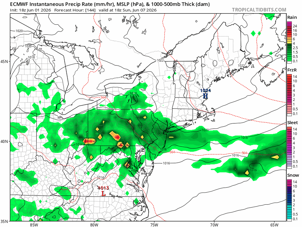
Picked up 0.11" of rain this morning. Meager, so hopefully more to come later today.
-

2026-2027 Strong/Super El Nino
snowman19 replied to Stormchaserchuck1's topic in Weather Forecasting and Discussion
Yea, that’s not cold. Solar irradiance from the roaring STJ -

2026-2027 Strong/Super El Nino
40/70 Benchmark replied to Stormchaserchuck1's topic in Weather Forecasting and Discussion
I feel like we could see some patterns set up that resemble the CANSIPS output..maybe even the entire month of January or February, but not the seasonal mean. -

2026-2027 Strong/Super El Nino
LakePaste25 replied to Stormchaserchuck1's topic in Weather Forecasting and Discussion
Those blues in the South do not necessarily equate to winter-like cold that would be supportive of snow outside of the appalachians. The blues are also there because it’s very stormy with the strong extended pacific jet feeding into the active southern stream. -
Well the good news if aurora does appear tonight it won't be cloudy.
-
Low of 55 here. Warming up quickly.
-
-

2026-2027 Strong/Super El Nino
mitchnick replied to Stormchaserchuck1's topic in Weather Forecasting and Discussion
Fwliw, Cfs2 is entertaining for February and March. December on the last run verbatim ain't so bad either for the Mid Atlantic, but dry up near you. The beauty of the Cfs2 is that it changes 4x/day, so everybody has a good run at some point of the day. Lol Starting in December. https://www.tropicaltidbits.com/analysis/models/?model=cfs-mon®ion=us&pkg=z500a&runtime=2026060400&fh=6 -
June 4 1935: The latest official measurable snowfall in Minnesota falls at Mizpah on this date with 1.5 inches. For Thursday, June 4, 2026 1825 - A hurricane struck Long Island NY leveling trees and causing damage to ships. The early season hurricane, which originated around Cuba, caused major damage along the Atlantic coast from Charleston SC to New York City. Many were lost at sea. (David Ludlum) 1860 - Iowa's Commanche Tornado , with wind speeds estimated in excess of 300 mph, was unquestionably one of the worst experienced by early settlers, with nearly a million dollars damage. (The Weather Channel) (Note: You can read about this tornado event here: https://www.tswails.com/single-post/the-camanche-iowa-tornado-june-3-1860 1982 - A four day storm began over New England which produced up to 14 inches of rain in southern Connecticut breaching twenty-three dams and breaking two others. Damage was estimated at more than 276 million dollars. (David Ludlum) 1987 - Early morning thunderstorms in south Texas produced 6.5 inches of rain at Hockheim, and five inches at Hallettsville, in just a few hours. Afternoon thunderstorms in Virginia deluged northern Halifax County with 5.5 inches of rain in two hours. Thunderstorms produced wind gusts to 76 mph at Dusty WA, and wind gusts to 88 mph at Swanquarter NC. (The National Weather Summary) (Storm Data) 1988 - A dozen cities in the eastern U.S. reported record low temperatures for the date, including Atlantic City NJ with a reading of 40 degrees. Fifteen cities in the north central U.S. reported record high temperatures for the date, including Glasgow MT and Havre MT with readings of 102 degrees. (The National Weather Summary) 1989 - Thunderstorms produced severe weather from the Southern Plains Region and the Lower Mississippi Valley to the Southern Atlantic Coast Region during the day and into the night. Just four tornadoes were reported, but there were 87 reports of large hail and damaging winds. (The National Weather Summary) (Storm Data)
-
2026-2027 Strong/Super El Nino
40/70 Benchmark replied to Stormchaserchuck1's topic in Weather Forecasting and Discussion
Yea, it's going to be warm in the mean. The question is will we have some respites from the jet...my early hunch is that we will. -
Light frost again this morning. Fourth time in the last week.
-
Records: Highs: EWR: 97 (1943) NYC: 99 (1925) LGA: 96 (1943) JFK: 91 (1971) Lows: EWR: 48 (1964) NYC: 48 (1926) LGA: 51 (2023) JFK: 49 (2023) Historical: 1814: A severe weather outbreak occurred across portions of Missouri, Illinois, and Indiana. The tornado in Wabash County was reportedly a mile wide, and crossed into Indiana. Damage from this tornado in forested areas was reportedly still visible in 1876. (Ref. Wilson Wx. History) 1825 - A hurricane struck Long Island NY leveling trees and causing damage to ships. The early season hurricane, which originated around Cuba, caused major damage along the Atlantic coast from Charleston SC to New York City. Many were lost at sea. (David Ludlum) 1825: A severe storm of tropical origin swept up the Atlantic Coast during the first week of June 1825 with reports of significant damage from Florida to New York City. Shipping logs told of a disturbance at Santo Domingo on May 28th and Cuba on June 1st. Gales were reported at St. Augustine, Florida on the 2nd. The Norfolk and Portsmouth Herald reported "undiminished violence" from the gale force winds for 27 hours, ending on June 4th. The effect of the storm reached well inland. Washington had cold, heavy rain all day on the 4th with high winds laying the crops in the vicinity. The wind also tore up trees by the roots in front of the State House in Philadelphia. This storm impacted the New Jersey Coast and the Long Island area as well with high winds and a two-foot storm surge. A Columbian frigate was driven ashore as were many smaller boats. The largest loss of life occurred along the Long Island shore when a schooner capsized. The entire crew of seven was lost. 1860 - Iowa's Commanche Tornado , with wind speeds estimated in excess of 300 mph, was unquestionably one of the worst experienced by early settlers, with nearly a million dollars damage. (The Weather Channel) 1877: A tornado of estimated F4 intensity touched down just west of Mt. Carmel, Illinois and moved east-northeast, devastating the town. 20 businesses and 100 homes were damaged or destroyed. At least 16 people and as many as 30 were killed, with 100 others injured. 1885: Pittsburgh, PA & Cleveland, OH received up to 10 inches of rain that caused serious flooding. (Ref. Wilson Wx. History) 1892: A rare June snowfall occurred at Cheyenne, WY with 8 inches reported also in 1937 Cheyenne, WY reported 3 inches of snow.(Ref. Wilson Wx. History) 1945: Several locations in the upper Midwest had their coldest June temperatures on record. La Crosse, WI and Waukon, IA dropped to 32°. This was their latest spring freeze and coldest June temperature. Other locations recording their coldest June temperature were Mondovi, WI: 29° and Richland Center, WI: 31°. (Ref. Wilson Wx. History) 1958: An F4 tornado tracked 32 miles through St Croix and Dunn Counties in Wisconsin, killing 20 people and injuring 110 others. (Ref. Wilson Wx. History) 1982 - A four day storm began over New England which produced up to 14 inches of rain in southern Connecticut breaching twenty-three dams and breaking two others. Damage was estimated at more than 276 million dollars. (David Ludlum) 1987 - Early morning thunderstorms in south Texas produced 6.5 inches of rain at Hockheim, and five inches at Hallettsville, in just a few hours. Afternoon thunderstorms in Virginia deluged northern Halifax County with 5.5 inches of rain in two hours. Thunderstorms produced wind gusts to 76 mph at Dusty WA, and wind gusts to 88 mph at Swanquarter NC. (The National Weather Summary) (Storm Data) 1988 - A dozen cities in the eastern U.S. reported record low temp- eratures for the date, including Atlantic City NJ with a reading of 40 degrees. Fifteen cities in the north central U.S. reported record high temperatures for the date, including Glasgow MT and Havre MT with readings of 102 degrees. (The National Weather Summary) 1989 - Thunderstorms produced severe weather from the Southern Plains Region and the Lower Mississippi Valley to the Southern Atlantic Coast Region during the day and into the night. Just four tornadoes were reported, but there were 87 reports of large hail and damaging winds. (The National Weather Summary) (Storm Data) 1993: Lynchburg had 70 mph winds, 95% of city lost power, 21 million damage. Severe thunderstorms were widespread from Missouri and Arkansas eastward to the Mid Atlantic states with more than 260 reports of severe weather, including over two dozen tornadoes. An early morning mesoscale convective complex over southern Missouri and north Arkansas moved eastward and evolved into a vicious derecho, traversing eastward across Kentucky in excess at 80 mph at one point. Wind gusts reached 100 mph near Elizabethtown, KY. Damage was widespread. 30 homes and mobile homes suffered major damage in Butler County. Over 75% of the roads in the county were blocked due to downed trees. 4.5 inch diameter hail fell at Smith Mountain Lake, VA. Total damage from the high winds at hail in Virginia was $60 million dollars, with $21 million of that occurred in the city of Lynchburg. 3.5 inch inch diameter hail was reported in Davie County in North Carolina. (Ref. Wilson Wx. History) 1998: The temperature at Williston, ND dropped to 26° to establish a monthly record for June. Neillsville, WI also reported their coldest June temperature as they dropped to 22°. The mercury dropped to 24° in Tower, MN as winter made one last call across the northern Plains. 2 to 3 inches of snow fell in portions of South Dakota and 7 inches fell in portions of Wyoming. (Ref. Wilson Wx. History) 2002: An individual in Fancy Gap, VA was injured slightly by lightning. (Ref. Lightning - Virginia Weather History)
-
80 / 49/ For some the start of the next heatwave 2nd, for most mid upper 80s. Fri - Sat and potentially Sunday get 90 - 95 range. Cut off ULL more offshore so less rain , unsettled weather Sunday and Monday. Heat pushes back in next week and overall warm to at times hot into mid month and beyond.
-
Same here, but by 10am… 43F to 73F.
-

Junorch obs and discussion 2026
Damage In Tolland replied to Damage In Tolland's topic in New England
Far NW MA. Nothing elsewhere - Today
-
-

2026-2027 Strong/Super El Nino
FPizz replied to Stormchaserchuck1's topic in Weather Forecasting and Discussion
I think he is fairly close to Erie PA. -
30 F recovery here so far... 48 to 78 It's only 9:30
-
We are so overdue for a legit, snowy and cold winter from start to finish. Bring it on. Kill the drought on Miller A at a time.
-