All Activity
- Past hour
-
Down to 50F this am, a few warm days ahead then see where things go
-

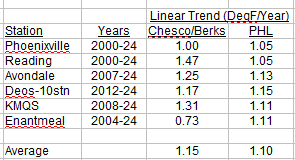
Chester County PA - Analytical Battle of Actual vs. Altered Climate Data
chubbs replied to ChescoWx's topic in Climate Change
Here's a chart and table combining the Chesco, Berks and Philly Airport (PHL) data from the previous page or two. No doubt about it, Chesco, Berks, and PHL are all warming at the same rapid rate.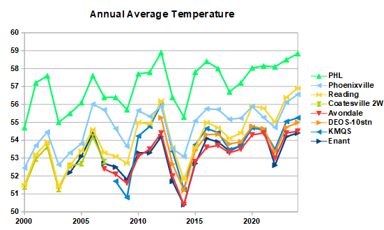
-
55 degrees for the low this morning. Grass is starting to turn brown in spots from lack of rain.
-
54 degrees early this morning.
- Today
-
 Very pleasant 55F right now
 -
Beavers isn’t even a top 100 prospect right now. So this roster manipulation bullshit is all for the vanishingly small chance that he gets added to those lists at the end of the season and then wins RotY in 2026. The big deal is that management is prioritizing this microscopic chance of an extra 2027 draft pick over the CURRENT FAN EXPERIENCE. They’re raising ticket prices and forcing fans to watch an outfield of Greg Allen (who??), Dylan Carlson, and Ryan Noda. If you had a healthy high-performing outfield this conversation would be moot. But it’s not. Your outfield is decimated and you have someone who’s knocking the cover off the ball at AAA.
-
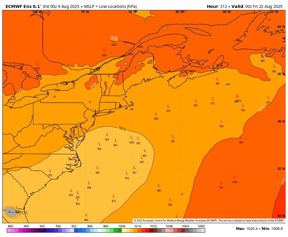
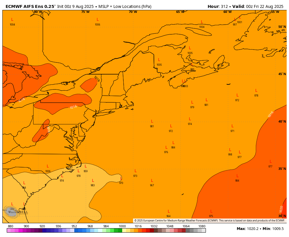
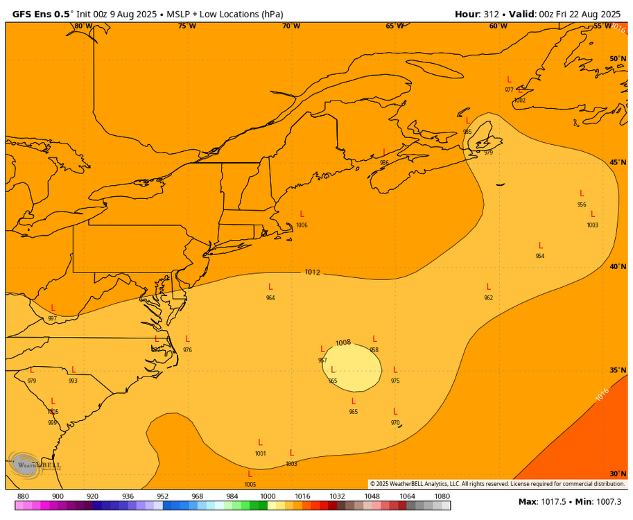
WB 0Z ensemble low locations at 0Z Friday.

-
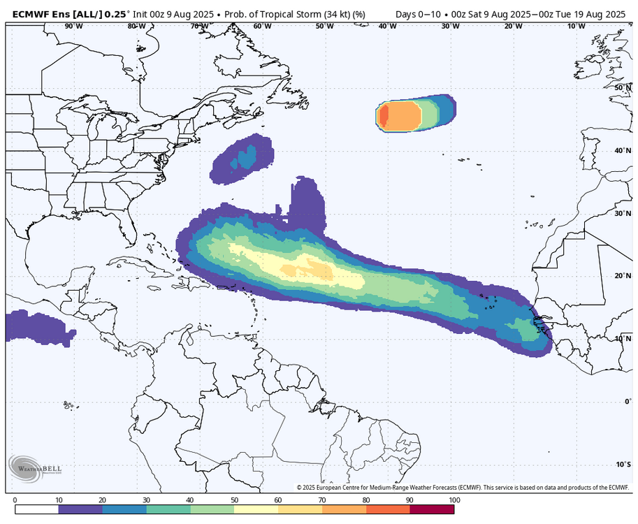
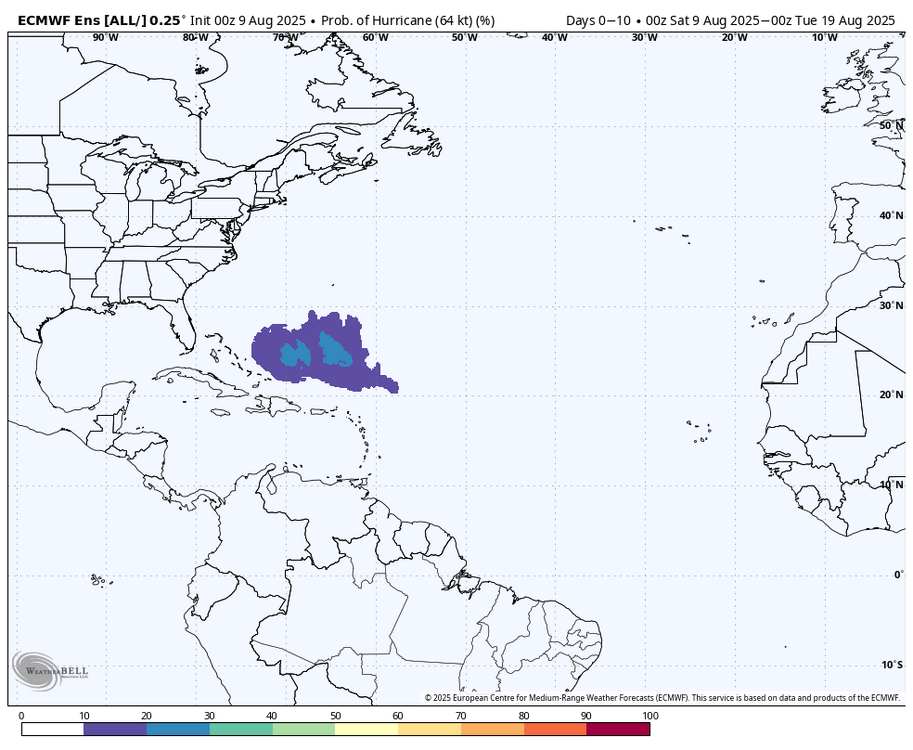
WB 0Z EPS tropical storm and hurricane probabilities through day 10.
-
Its a start-
-

2025-2026 ENSO
40/70 Benchmark replied to 40/70 Benchmark's topic in Weather Forecasting and Discussion
Heh....case en point, John.....even this image of an ostensibly favorable pattern breaks your "Miami rule" of greater than 580dm heights. -
2025-2026 ENSO
40/70 Benchmark replied to 40/70 Benchmark's topic in Weather Forecasting and Discussion
True. It will be interesting to analyze how we "thread the needle", so to speak the next time the east coast scores on a grander scale. -
-
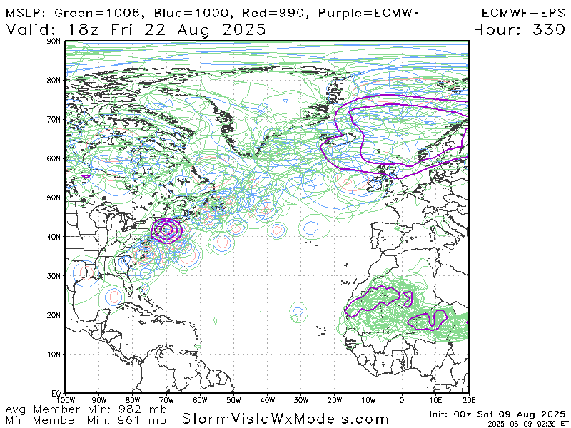
0z EPS gone wild.. sucks it's so far out
-
Days and days of weenie runs at fantasy range
-
0z Euro Please!!! 958mb over far eastern Ma /Cape
-
Bring on 2026... it is going to be great.
-
Sure beats the cold rain we are likely to endure this upcoming winter. The coldest rain that is even possible. Book it. Mark your calendar, etc.
-
Fixed.
-
Hm...well then there's the other part of bringing up your best prospect and having them sit on and off the bench just to avoid the 130 mark. Teams may prefer more consistent playing time for the best ones? Just speculating
-
I have one of those. It's a good Station overall. Accurate T, RH, Rain, Solar. 14 second updates not bad for budget Station. Biggest con is Windspeed runs low the higher the Winds, at least with mine. Customer support is good. I also have a Logia 7-1 . It has been very accurate overall. It was right with my Davis irt accuracy. T Sensor failing after 3 year's.
-
Anthony? Is that you?
-

2025-2026 Winter Speculation Thread
WintryMixmaster replied to Carvers Gap's topic in Tennessee Valley
That is a good point, I forget how different the weather can be between downtown Knoxville and TYS (January 2024 had a sharp cutoff for accumulations right by the airport too). My first 3 winters here were spent in Hardin Valley and I remember being jealous of the Powell/Fountain City area posters that often had just a bit more elevation and were a bit further northeast. Last winter was my first winter in the Concord/Northshore town center area and I'm dreading the inevitable storm where Hardin Valley gets snow and I see nothing -
2025-2026 Winter Speculation Thread
WintryMixmaster replied to Carvers Gap's topic in Tennessee Valley
Well hopefully I'm good luck for Knoxville- I remember that March 2022 snowstorm and being a bit sad thinking I might never see that kind of storm again here... and then January 2024 came around haha. I did notice that the tri-cities seemed to get the short end of the stick these past few winters despite averaging more snow than Knoxville, it's really interesting how the shape of the valley influences which storm types are better/worse for which areas, despite how geographically close TRI/TYS/CHA all are. Blount/Sevier counties got warm nosed in January 2024, but they also get some solid accumulation during NW flow events while in West Knox I've usually seen flurries or a dusting at best from those. Chattanooga seems like a snow lovers nightmare where anything that can go wrong will go wrong, I was glad they finally got to cash in last January. I remember the post you're referencing about the natural spillway for cold air into the valley and it makes sense that it would work in favor of the Knox area. This might be a dumb question, but do you think that there's a correlation between the very strong pacific jet stream that we've seen in recent winters and the shift in snow between the tri-cities and Knoxville? As a novice, it seems like Nor'Easters and Apps runners/Great Lake cutters are less common than I remember from the 2002-2010 period when I followed the weather more closely - but sliders that move west to east and weaker storms that ride along a frontal boundary are more common, and Knoxville has cashed in when one of them is timed correctly with a shot of cold air that briefly buckles the flow. Would the ideal storm track for TRI be something that is more south to north, so that a strengthening storm east of the valley would bring winds from the north? -
True. But keep in mind the heights in my plot are being skewed lower by some of the older years being measured against today’s means. The same pattern as say a 1958 or 1960 wouldn’t produce nearly as negative an anomaly today (by 1960s standards) and a might more positive anomaly over the high latitudes as well. Of course we could argue whether the same pattern would even produce similar snow now given the mean heights have increased significantly.