All Activity
- Past hour
-

Central PA Fall Discussions and Obs
canderson replied to ChescoWx's topic in Upstate New York/Pennsylvania
It’s been a while but extremely good high end chocolate -

Central PA Fall Discussions and Obs
Jns2183 replied to ChescoWx's topic in Upstate New York/Pennsylvania
@canderson have you had any experience with Frederic Loraschi Chocolate? Sent from my SM-G970U1 using Tapatalk -

December 2025 Short/Medium Range Forecast Thread
jaxjagman replied to John1122's topic in Tennessee Valley
East Asia gives you some insight of the pattern ahead,yes its never gonna be right because we have different teleconnections,sorta speaking.But honesltly 1,E,you see a ridge building into Mongolia into maybe even Russia,nothing but a trough in a few days as we head towards T-GIVING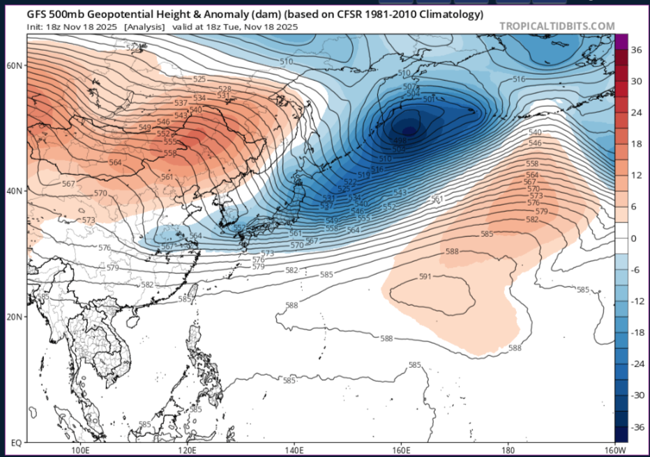
- Today
-

Mountain West Discussion
mayjawintastawm replied to mayjawintastawm's topic in Central/Western States
.07" here. A deluge, indeed. -
Didn’t matter if it was the NWS broadcast or a radio station but the excitement when the forecasted accumulations jumped up! I agree on the info overload nowadays, it’s not nearly as exciting.
-
Yes Eastern sections had a nice winter
-

E PA/NJ/DE Autumn 2025 Obs/Discussion
simbasad2 replied to PhiEaglesfan712's topic in Philadelphia Region
Is it too early to start looking at December? Unfortunately it seems like strong east coast ridging will kick off meteorological winter for us. Still far away, but most long range ensemble guidance supports temps reaching the 50s-70s. Thankfully short lived though as a really cold air mass will advect eastward by around December 5th. EPS Weeklies support a weak SER around this time, so maybe some overunning events next month? -
Urging caution when going out beyond 180hrs in a Nina. But alas, majority here are already aware of this.
-
Welcome to Nina December reality.
-
Nothing questionable that the Orioles do surprises me.
-
I am surprised the Orioles tendered an offer to Mountcastle.
-
For those of you that like to reminisce: Some good memories here. If you watch till the end what do you prefer? The information overload of today or the way is used to be. For me the information of today is great but there was something "magical" as a kid (70's and 80's) with just evening newscasts, scanning the radio dial (1010, 880, 1130) and my little radio shack weather cube. Personally I'm glad I grew up in that era. If you are not old enough to remember any of that you missed out on great times in my opinion. Who can forget the Winter Storm Watch being downgraded to a Travelers Advisory???? Always a great disappointment.
-

Occasional Thoughts on Climate Change
TheClimateChanger replied to donsutherland1's topic in Climate Change
-

November 2025 general discussions and probable topic derailings ...
frd replied to Typhoon Tip's topic in New England
Thats a bummer. Some feel the Mid Atlantic will do well because it is a Nina and its December, however I think we end the month below normal snowfall here, which by Dec. climo is not that much anyway, as far as temps its up and down. Basically nothing remarkable down here. Winters are not great anymore for cold and snowlovers in my hood. -
-

Pittsburgh PA Fall 2025 Thread
Ahoff replied to TheClimateChanger's topic in Upstate New York/Pennsylvania
Of course it's not impossible. -
Dec 6th it is !
-

2025-2026 ENSO
40/70 Benchmark replied to 40/70 Benchmark's topic in Weather Forecasting and Discussion
Same page with him on that, but I think we see a reversal in February. -

E PA/NJ/DE Autumn 2025 Obs/Discussion
Kevin Reilly replied to PhiEaglesfan712's topic in Philadelphia Region
It’s the exact same thing every year for the past 5 years or so. Welcome to our new normal of Pacific warm dominated weather pattern with a sprinkle of flat ridges from the warm Gulf of Mexico and southwestern Atlantic this the cause of your erratic rainfall amounts and very little snow. -
I was thinking similarly. If it stays warm up north and doesn't build serious cold early when it's dark, what's left for us later. Considering the warmer background state it seems that as the cold degrades winter will struggle to stay.
-
December will be very good for us...it's the mid Atlantic that will take the shaft. Not worried in the least. My December analogs show this well.
-
I think I'll do fine in December.
-
Don’t worry. I always start off strong when there’s nothing to lose. in 45 days. I’ll be falling apart.
-
(002).thumb.png.6e3d9d46bca5fe41aab7a74871dd8af8.png)
Central PA Fall Discussions and Obs
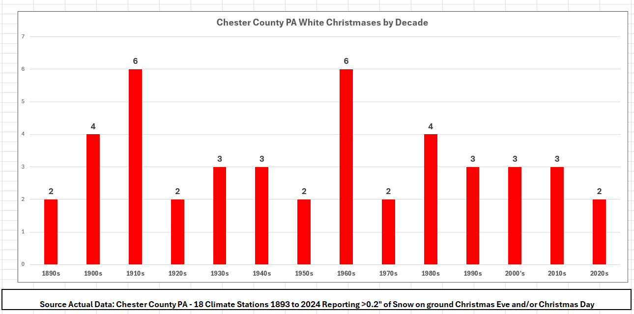
ChescoWx replied to ChescoWx's topic in Upstate New York/Pennsylvania
Well, I have completed some deep analysis across all of the Chester County and SE Berks County PA climate sites to see how often we have seen a White Christmas here in the western Philadelphia suburbs of Chester and SE Berks Counties. Now what is up for debate is what represents a White Christmas?? For purposes of this exercise, I am considering measurable snow on the ground (+0.2") on either December 24th or December 25th before midnight. Some interesting statistics of note. We have received Holiday Week snow during Christmas week (December 17th through 25th) in 77 of the 132 years or 58% of all Christmas seasons We experience a White Christmas somewhere in Chester/SE Berks Counties about 1 out of every 3 years or 34% of all years. We have received measurable snow on 29 Christmas Eve or Days (22%) 16 measurable snows on Christmas Eve 13 measurable snows on Christmas Day One inch or more snow was on the ground: 32 times on Christmas Eve (24%) 31 times on Christmas Day (23%) Our last White Christmas was last Christmas Eve Day when 0.5” fell at East Nantmeal and 0.4” at Octoraro Lake on December 24th. Below is the number of White Christmases by Decade including the partial decades of the 1890’s and our current decade the 2020’s.