All Activity
- Past hour
-
-
Mercy that is a rather depressing prospect for snow...and I wanna put "WPAC Warm pool" on a dart board right about now, lol And let me guess...that warm pool is climate right? Smh
-

First Legit Storm Potential of the Season Upon Us
CoastalWx replied to 40/70 Benchmark's topic in New England
Reggie is better at 500vs 6z -

First Legit Storm Potential of the Season Upon Us
ineedsnow replied to 40/70 Benchmark's topic in New England
Not liking the trends for this.. but I am liking the trends for tomorrow here -
Reggie is a light snowfall
-

First Legit Storm Potential of the Season Upon Us
MJO812 replied to 40/70 Benchmark's topic in New England
Reggie is still decent but slightly lowered amounts. -
Well, the Canadian goes from rain to snow for NE NC.
-

2025-2026 ENSO
TheClimateChanger replied to 40/70 Benchmark's topic in Weather Forecasting and Discussion
Shows up really well on the rankings too, with almost every station out there seeing its warmest winter to date. -
Started to post last night irt the WRF being as warm as it was. It seems it's been the warmer outlier Exactly. We need the STJ to become active out of the Pacific and across Mx the SW and Southern Plains. That dryness there helps extend that ever present SW Heat Ridge, if you will, Eastward to the Gulf. That hinders our moisture transport and LP development there as well.
-

First Legit Storm Potential of the Season Upon Us
Spanks45 replied to 40/70 Benchmark's topic in New England
Definitely looks like it is ticking east too at 12z, still spreads precip well west into western New york -

Pittsburgh/Western PA WINTER ‘25/‘26
colonel717 replied to Burghblizz's topic in Upstate New York/Pennsylvania
-
First Legit Storm Potential of the Season Upon Us
MJO812 replied to 40/70 Benchmark's topic in New England
Icon miss Reggie slightly flatter -
2025-2026 ENSO
TheClimateChanger replied to 40/70 Benchmark's topic in Weather Forecasting and Discussion
This has been a very favorable pattern for the eastern U.S. overall since December 1. You can see departures in the intermountain west as high as +16F to +18F for the winter season to date. Really can't complain about this look. Could be a LOT worse. -
Yes please
-

First Legit Storm Potential of the Season Upon Us
Kitz Craver replied to 40/70 Benchmark's topic in New England
Let’s wait for the big leagues -

First Legit Storm Potential of the Season Upon Us
HoarfrostHubb replied to 40/70 Benchmark's topic in New England
I'm pretty confident about Saturday... I think Sunday/Monday is up in the air for my area... leaning nothing much -
ICON is a whiff for Sunday. Came a bit west from where it was, but still a whiff. Let's see what the other models have to say. At some point, I don't think they can keep showing a whiff if this thing is real, we're 48 hours left. I'd hate to be the NWS with this one.
-

January 2026 regional war/obs/disco thread
weatherwiz replied to Baroclinic Zone's topic in New England
Just looked at 0z/6z models for second half of the week and holy hell what a disparity. I will say though and I think I mentioned this the other night...that is one powerful Arctic front slated to drop South and I would find it hard pressed not to see at least one major winter weather event impact a large geographical area. I think the biggest question is going to be the timing...does this happen during the second half of the week (similar to the 6z GFS) or does this get pushed back say 2-3-4 days? I would definitely watch anywhere from the mid-South into the Northeast. -
6z GFS no squashy.
-
I have been, and it does not
-

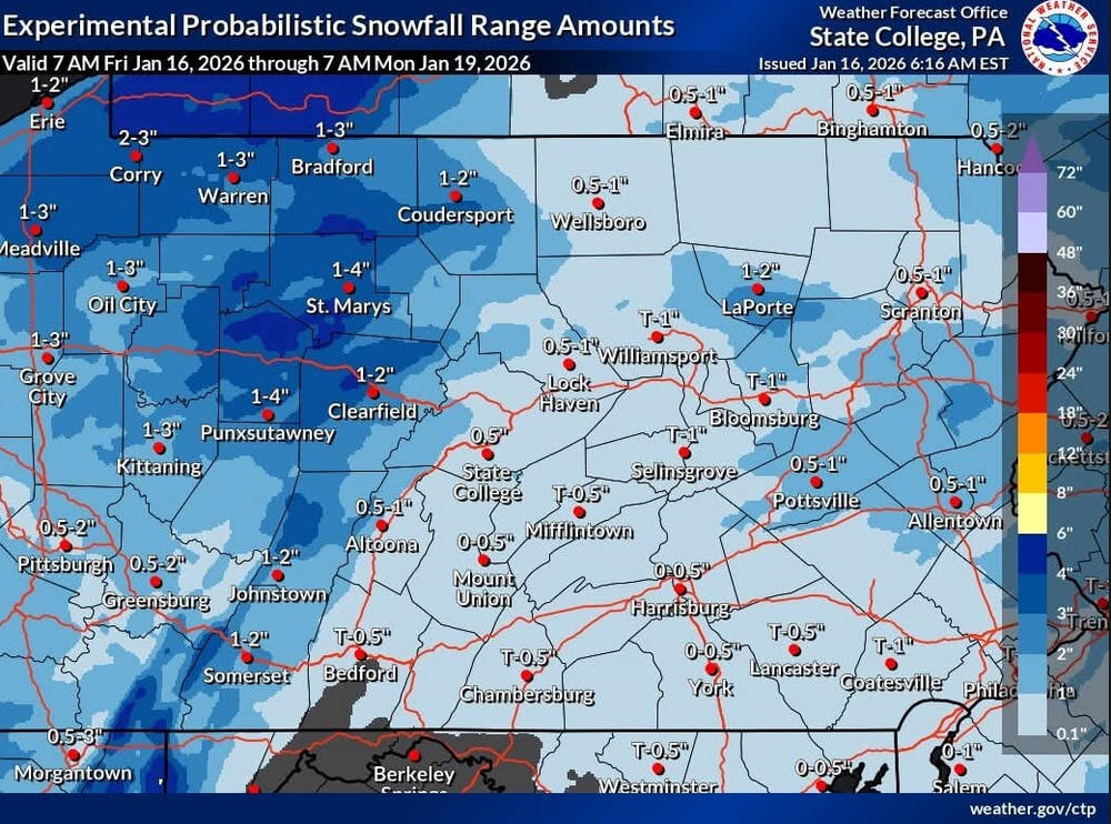
Central PA Winter 25/26 Discussion and Obs
mitchnick replied to MAG5035's topic in Upstate New York/Pennsylvania
Maybe if the Gfs could pump out multiple runs in a row showing similar results, it could be believed. The run-to-run inconsistencies are abhorrent. And in case you're wondering where I got that word, my wife has been using it a lot lately. -
This could take some time to make it to the northeast as we slowly scour out the cold air and also risk CAD setups. I’m eyeing early Feb for the warmup here.
-
.
-
That is cool .
-

First Legit Storm Potential of the Season Upon Us
SouthCoastMA replied to 40/70 Benchmark's topic in New England
Many spooked by the NAM, and jaded by the recent years. I get it, but it holds little wait until we see the others start doing the same.


