All Activity
- Past hour
-
Toasty Euro run
-
79/42 A 40-degree diurnal rise day off 39F.
-
yeah by like 5 second a day at first
-
2:45 pm and it's 79/47. Humidity at 33%. Amazing for June.
-
80/48
-
That’s the biggest difference I see and that kind of brings us into the summer vibe.
-
Or at least if/when there are post BDs or N-door boundaries regionally we're going back to 72s instead of 49s yup.
-

E PA/NJ/DE Summer 2026 Obs/Discussion
The Iceman replied to PhiEaglesfan712's topic in Philadelphia Region
Looking like a lock that most area's receive < 1" precip from now through mid month. Best shot of any precip comes sunday but the timing is looking poor. Maybe some showers but not the best set up for convection despite the frontal passage. After that looks like another week of bone dry. -
18 more days and days start getting shorter @MJO812
-
I think we’ve made it past the worst part of spring cold rains. Most days looking forward look AOA normal temperature wise and plenty of sun.
- Today
-
12z GFS not awful, at least for western portions of this sub comfortable temps have def kept things from drying out too much with things still p green but that will probably change quick with some heat if we don't get another soak soon
-

Central PA Summer 2026 Discussion/Obs Thread
Mount Joy Snowman replied to Voyager's topic in Upstate New York/Pennsylvania
Heck yeah, I feel like I've had the windows open for a week straight. -
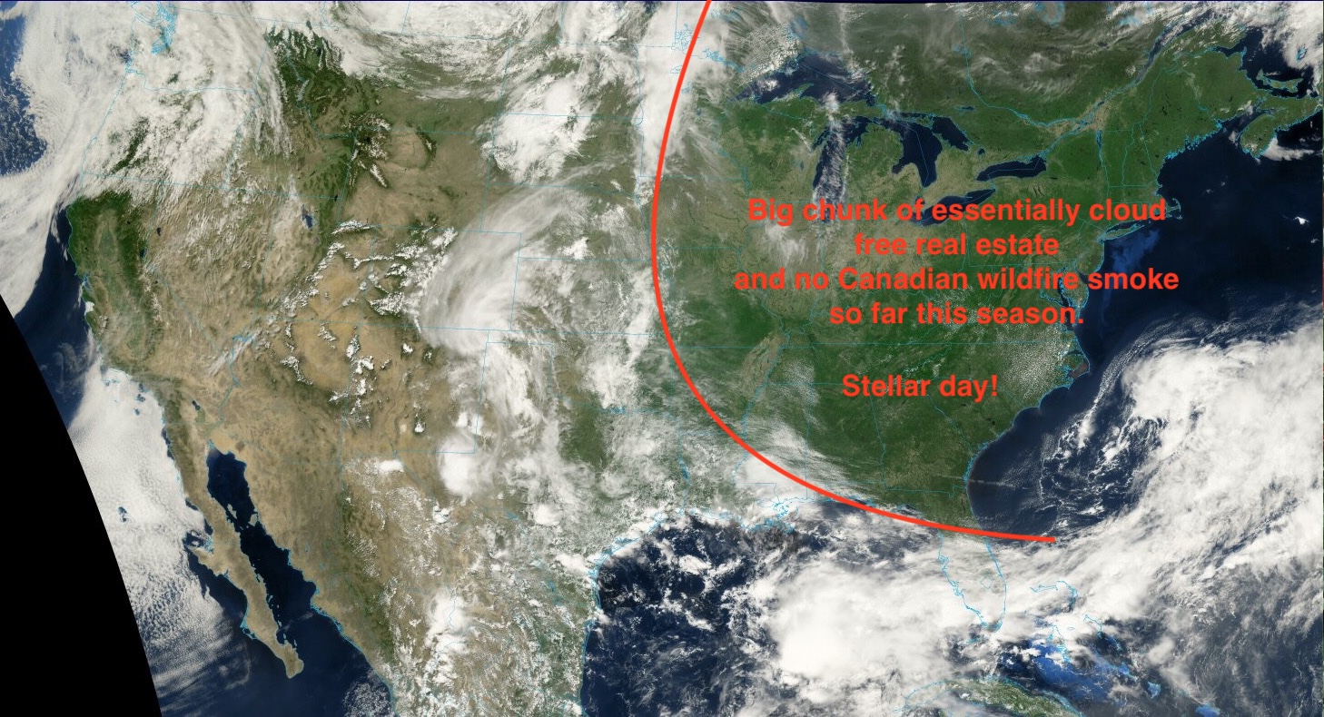
rare satellite image
-
Hey yoda, Thanks. Would you please post this in this newly created 2026 C and E Pacific tropical thread? TIA.
-
Please post 2026 C and E Pacific discussion/activity in here. Thank you.
-
you should name your dog "Boat" bring on another thousand
-
84 in Kearny, NJ. Not a cloud in sight. Gorgeous out.
-
Low was 46.1 here. Currently 72.3/50.0 with partly cloudy skies at 1:30 pm.
-
It has begun in the EPAC BULLETIN Tropical Storm Amanda Advisory Number 4 NWS National Hurricane Center Miami FL EP012026 800 AM PDT Wed Jun 03 2026 ...DEPRESSION STRENGTHENS INTO THE FIRST TROPICAL STORM OF THE 2026 EASTERN PACIFIC HURRICANE SEASON... SUMMARY OF 800 AM PDT...1500 UTC...INFORMATION ---------------------------------------------- LOCATION...10.6N 128.2W ABOUT 1475 MI...2375 KM WSW OF THE SOUTHERN TIP OF BAJA CALIFORNIA MAXIMUM SUSTAINED WINDS...40 MPH...65 KM/H PRESENT MOVEMENT...NW OR 305 DEGREES AT 8 MPH...13 KM/H MINIMUM CENTRAL PRESSURE...1006 MB...29.71 INCHES WATCHES AND WARNINGS -------------------- There are no coastal watches or warnings in effect. DISCUSSION AND OUTLOOK ---------------------- At 800 AM PDT (1500 UTC), the center of Tropical Storm Amanda was located near latitude 10.6 North, longitude 128.2 West. Amanda is moving toward the northwest near 8 mph (13 km/h) and this motion is expected to continue through Friday. A turn toward the west and west-southwest at a slower forward motion is forecast this weekend. Maximum sustained winds have increased to near 40 mph (65 km/h) with higher gusts. Additional strengthening is forecast during the next couple of days. A weakening trend is forecast later this weekend. Tropical-storm-force winds extend outward up to 60 miles (95 km) from the center. The estimated minimum central pressure is 1006 mb (29.71 inches).
-
Tropical ATL predictions so far ITT: ineedsnow 11/4/2 me 8/4/1 ACE 52 LongBeachSurfFreak 12/5/2 Jconsor 13/6/2 ACE 90 Any others? Please get your entries in by Sunday evening. The winning prize is fantastic, a kudos!
-

2026-2027 Strong/Super El Nino
GaWx replied to Stormchaserchuck1's topic in Weather Forecasting and Discussion
The model progs are suggesting a shot at a 1017 mb Darwin SLP on June 7th. If that occurs, it would easily become the new highest Darwin SLP that early in the year based on records back to 1992. The current record highest that early in the year is 4/22/2023’s 1016.2 mb. If it reaches 1017, it would become the earliest 1017 on record by ~15 days! -
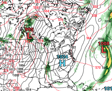
 Tried to look at the 500mb to get a better answer. As others in this thread have said the basic issue is we are stuck in a NW flow pattern. The maps (one from our rainy week a couple weeks ago and one from a day ago) show the difference This one clearly shows a southeast ridge with a ULL in the plains which helps transport moisture up the east coast and wring it out. Clearly, this is the pattern we need to get some rain. Notice the wind barbs out of the southeast from the Gulf. Meanwhile, this is the pattern we get. Beautiful weather but no moisture to be found in the upper air (unless you're hoping the Great Lakes save us). You can see the ULL over Maine with a ridge over the center of the country. Now, the question is will things actually change? Using the EPS to look forward and its not great. The forecast through at least next week is paltry with the upper air moisture transport as a ridge intensifies to our north. However, by mid month the pattern starts to breakdown and we see a more favorable setup return. The GEFS suggests a similar reshuffling that helps us out as well. In the meantime, we're sorta cooked.
 -
ICONoclastic model's settin up a blistering heat wave June 9-10-11 ... just like the original non-linear telecon signal had from last week. This is the 12z next Wed ... notice 570+dm with lee side trough? this is 90+ incoming
-
I’m super cautious as well, especially considering what we went through with the previous dog. Vet told us the same thing. Monitor over the next hour and if we notice her becoming in discomfort to bring her to the ER, otherwise we can wait until the 3:30 appointment. Also said to give her 25mg of Benadryl.