All Activity
- Past hour
-
Weather models are absolutely getting worse. I don’t give a crap what anyone tries to tell me.
-
-

White Christmas Miracle? December 23-24th
TauntonBlizzard2013 replied to Baroclinic Zone's topic in New England
Was March 14 where we had that epic storm bail last minute? If I remember it still got the cape and buried Atlantic Canada. -
I'll go out on a limb and say that I expect a pretty wet period for a lot of the West in January. I believe that's part of the transition out of the current pattern. CFS is pretty wet nationally for the US - something like 2/3 of the country is depicted as wetter (and warmer) than last January currently.
-
Ukie is wonky. Showing sleet to NH
-
-
Shifted a bit north but pretty much noise.
-
It also went insanely north with yesterday's event at about 48-60 hours out too. Given nothing else at 00Z did that I'd not really change any ideas yet. The RRFS/RGEM at this range have recently tended to have slight suppression/amped biases respectively so something near what the GFS shows is what I'd go with now
-

Winter cancelled/uncancelled banter 25/26
Santa Claus replied to Rjay's topic in New York City Metro
bird strike just took out Cupid and Prancer, i’m losing altitude rapidly -
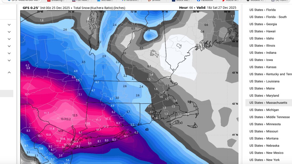
GFS Kuchera
-
I would ignore the NAM. It does whacky things like this sometimes. When the GFS is much colder, snowier and has support from the Rgem and others, it’s a great sign for snow lovers.
-
-

26th-27th event, coming at us like a wounded duck.
weatherwiz replied to Go Kart Mozart's topic in New England
Just have to hope we remain with positive trends at 12z -

26th-27th event, coming at us like a wounded duck.
Ginx snewx replied to Go Kart Mozart's topic in New England
Lol turds away -

26th-27th event, coming at us like a wounded duck.
CoastalWx replied to Go Kart Mozart's topic in New England
It’s super cold so these nrly bumps will allow better inflow at 925-850 and get some moisture off the ocean. -

26th-27th event, coming at us like a wounded duck.
RDRY replied to Go Kart Mozart's topic in New England
Berks smile at the north bumps. -
So, is Friday night's storm going to hit Bermuda Saturday night?
-

26th-27th event, coming at us like a wounded duck.
ORH_wxman replied to Go Kart Mozart's topic in New England
Yeah GGEM shifted north too. You get a couple more of those and then you’re getting serious snow into pike region. -
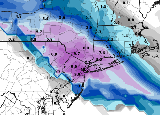
GFS @ 10:1 is 6" - 10" for all, with NYC the bullseye
-
Someone down near Philly is gonna get like 3 inches of sleet from this
-

26th-27th event, coming at us like a wounded duck.
Go Kart Mozart replied to Go Kart Mozart's topic in New England
Fabulous GFS run, but it will be a shame if we get a foot and NEMA gets zero. Moohaha, hahaha , HAHAHA!. -
Too early for timing? I have to get from Rockland to Yankee Stadium Saturday morning for the Pinstripe Bowl. .
-

December 2025 Short/Medium Range Forecast Thread
John1122 replied to John1122's topic in Tennessee Valley
Mammoth has gotten 28 inches as of 4pm local time. The forecast through Friday. "Tonight Snow. Steady temperature around 20. Wind chill values as low as -1. Windy, with a south southwest wind 30 to 35 mph, with gusts as high as 55 mph. Chance of precipitation is 100%. Total nighttime snow accumulation of 26 to 32 inches possible. Christmas Day Snow. High near 20. Wind chill values as low as -3. Windy, with a south southwest wind around 30 mph, with gusts as high as 60 mph. Chance of precipitation is 100%. New snow accumulation of 33 to 39 inches possible. Thursday Night Snow showers. The snow could be heavy at times. Some thunder is also possible. Steady temperature around 20. Wind chill values as low as -1. Windy, with a south southwest wind around 35 mph, with gusts as high as 60 mph. Chance of precipitation is 100%. New snow accumulation of 23 to 29 inches possible. Friday Snow showers before 1pm, then snow, mainly after 1pm. The snow could be heavy at times. Some thunder is also possible. High near 18. Wind chill values as low as -4. Windy, with a southwest wind 25 to 30 mph decreasing to 20 to 25 mph in the afternoon. Winds could gust as high as 55 mph. Chance of precipitation is 100%. New snow accumulation of 9 to 13 inches possible." -

26th-27th event, coming at us like a wounded duck.
WxWatcher007 replied to Go Kart Mozart's topic in New England
Canadian further NE from 12z. Just keep ticking…GFS now gets (minor) precip up here. -
Wow man, Mammoth has picked up well over THREE FEET of fresh snow today! That wind is blowing that pow all over the damn place! Forecasts have another 3-4 feet piling up tomorrow! Man, that wind!!! https://www.mammothmountain.com/on-the-mountain/mammoth-webcam/main-lodge