All Activity
- Past hour
-
How?
-

Outta gas and Outta Time: Early March Winter Storm finale
mitchnick replied to Ji's topic in Mid Atlantic
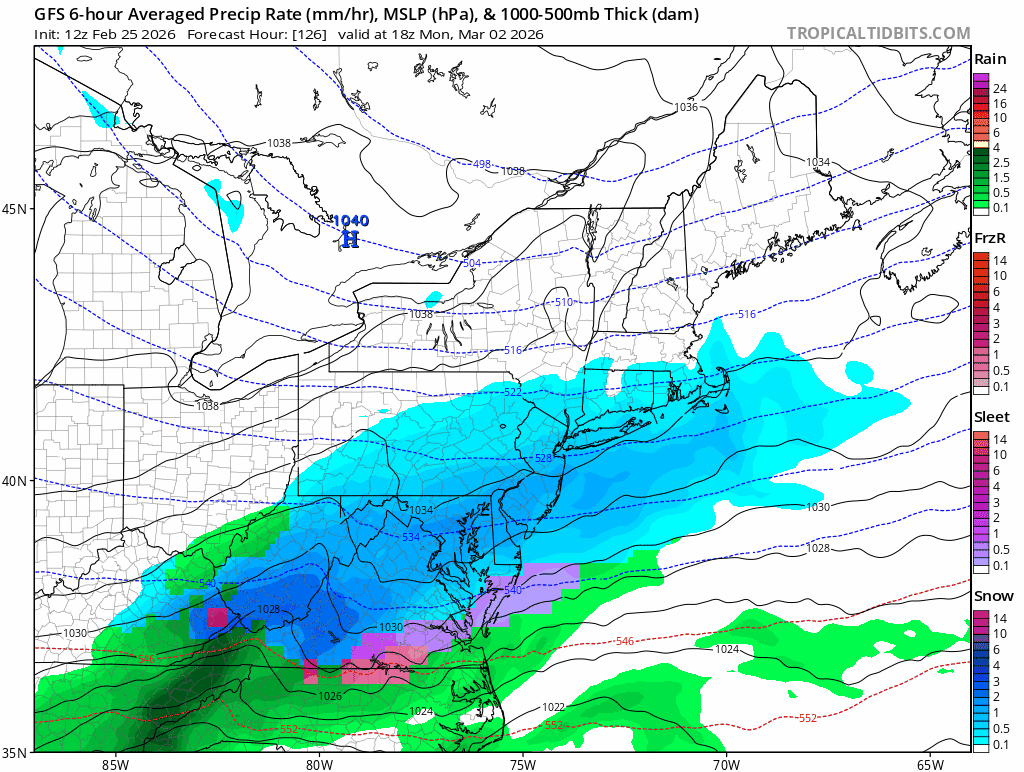
Euro dry as a bone east of mts.
-
I was saying that to my dad just the other day. I’m going off of nothing other than experience. It has *that* feel. .
-
T shirt weather outside. 5 day suspension for the thread starter.
-
Outta gas and Outta Time: Early March Winter Storm finale
mitchnick replied to Ji's topic in Mid Atlantic
Euro doesn't look like it will be south. Dry? Can't tell. -
Outta gas and Outta Time: Early March Winter Storm finale
mitchnick replied to Ji's topic in Mid Atlantic
See my post re EuroAI. Lol These models have done nothing but ruin this winter. -
At least maybe we go straight into severe wx tracking

-
The old “blocking leads to meh snowfall” reinforcement up north, ha. CAR temps have been right around 0.0 departures for two months in the means too.
-
Outta gas and Outta Time: Early March Winter Storm finale
mitchnick replied to Ji's topic in Mid Atlantic
EuroAI came north. Lol.thumb.png.ca977345b62958cf8162dae7bf3dd87e.png)
-

February 2026 OBS & Discussion
donsutherland1 replied to Stormlover74's topic in New York City Metro
1995-1996. -

Outta gas and Outta Time: Early March Winter Storm finale
North Balti Zen replied to Ji's topic in Mid Atlantic
Consistent with the seasonal trend @mitchnick -
We got around a half inch of sleet/snow/something overnight from the squall. Definitely a bit crunchy
-
Yeah nothing to really sink your teeth into
-
Simple, well I guess your name fits. I've read miscellaneous rants here, but rarely have i observed someone acting like such an ASS to a simple comment. Did I miss something? Why were you so triggered?
-
Euro ai has something late next week but the models have been all over. Just not a good signal at the moment.
-
Next week is becoming un-exciting
- Today
-

Outta gas and Outta Time: Early March Winter Storm finale
snowfan replied to Ji's topic in Mid Atlantic
WPC got this out before the 6Z GFS OP. LOL
-
Outta gas and Outta Time: Early March Winter Storm finale
snowfan replied to Ji's topic in Mid Atlantic
Just sliding away…
-

Outta gas and Outta Time: Early March Winter Storm finale
Weather Will replied to Ji's topic in Mid Atlantic
WB 0Z EPS has another shortwave behind Monday's storm which is kicking our threat out to sea. Not enough spacing. Too bad but right now threat for anything is greatly diminished in the DMV. No model is showing a storm here.
-
Now the models are suddenly trying to turn Sunday into an “event”. Very light….1-2, 1-3 mainly N and W of the city. I’ve never seen the models flip flop and suddenly change and in some cases flat out bust horribly in the short term as much as they have been this winter in all my years of being a weather hobbyist
-

Outta gas and Outta Time: Early March Winter Storm finale
CAPE replied to Ji's topic in Mid Atlantic
There is a storm, just not for us on this run. Congrats Bob Chill -
Gfs no storm
-

E PA/NJ/DE Winter 2025-26 Obs/Discussion
Duca892 replied to LVblizzard's topic in Philadelphia Region
Squash city -
E PA/NJ/DE Winter 2025-26 Obs/Discussion
Duca892 replied to LVblizzard's topic in Philadelphia Region
Well… things are looking rather glum… but screw it… I’m up and the 6z GFS IS ROLLING -

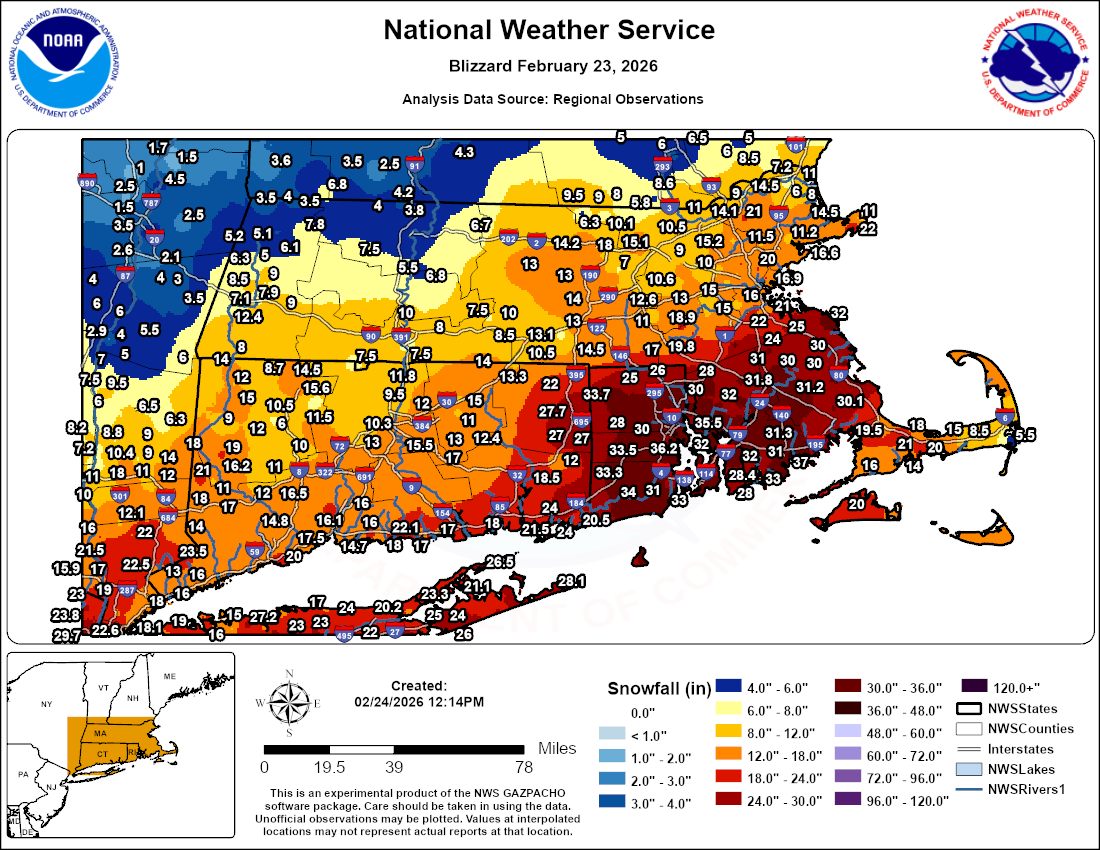
"Don’t do it" 2026 Blizzard obs, updates and pictures.
vortex95 replied to Ginx snewx's topic in New England
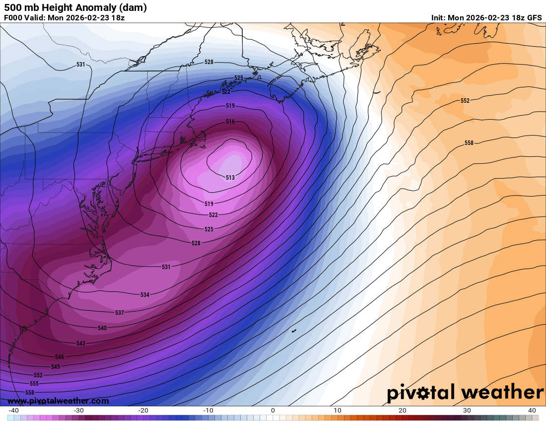
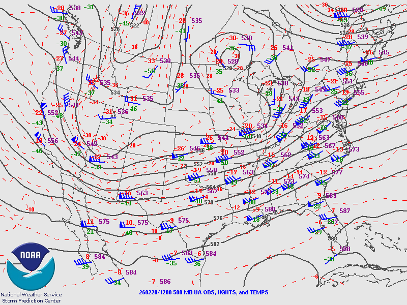
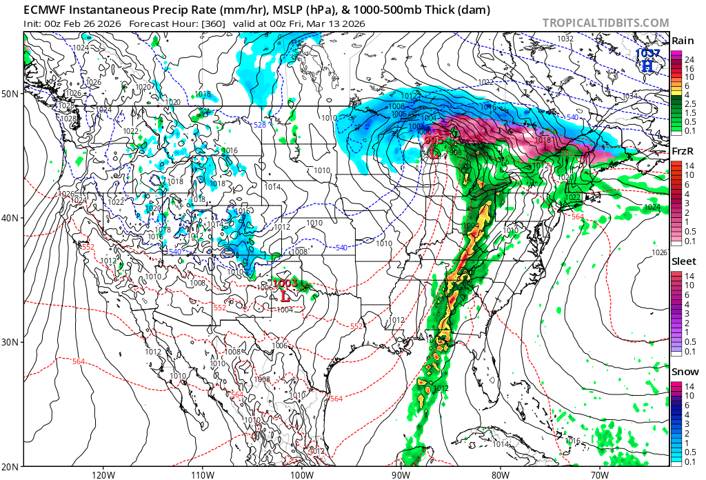
Talking about low track, this storm was a bit odd. It tracked just outside the benchmark, yet you look at the SNE snowfall plot (attached), things stand out. To have ptype issues or lacking big snowfalls on the Outer Cape, and yet heavy snow lacking once you get to the NH border and in the Berks, and monster totals "wedged" in-between, is atypical for a New England snowstorm. Typically, if the S+ does not make it into NH or Berks, there are *no* ptype issues in SNE or any issues are corrected quickly due to the ageostrophic flow/backing winds as the low wraps up well to the S and SE, so even the Outer Cape will do just fine, at least later in the winter season. Sure, PVD gets an all-time snowfall smashed, but BOS/ORH/CEF/BDL not even top 10, in fact, not even *close* for any of these cities? That's quite a disparity, probably the biggest one on record for a New England snowstorm. So in some ways, this was *not* a classic snowstorm for SNE or New England. The storm's big S+ area was rather confined and small N and NW of the low center, and the models overdid the big amounts in Berks and srn VT/NH until the last minute. I was confident 15-25" would make it into these areas, why not?, based on the track of the sfc low, that's what you'd expect! Do I sound pedantic? Well, the details count here, as they do in all sciences. Subtle differences not so obvious can and are *huge* as to sensible wx for an event. I go back to my previous (long) post on this thread, "one size does not fit all" and thus you can't gloss over any event calling it "perfect" or "classic" or "what it should be." That's not how the wx, climate, and atmosphere work. One explanation I think for the odd snowfall pattern/gradient is the cut-off 500 low stayed well offshore. For the best expansive comma head S+, you want sfc low right near the benchmark, but the 500 low to pass right over or very close to the BOS-ORH-BDL-PVD zone. You get the biggest height falls and max dynamic cooling aloft, so "part 2" of the storm (no mdt-hvy snow break though) is solid fluffier, more convectively-driven snow. In this case, the 500 low as it passed SNE was almost co-located w/ the sfc low. That's not common for a classic blockbuster for New England. Why was that? Well, no blocking over NAMR for one. In fact, deep 500 low near Greenland! Second, no polar jet at all. Just one big solid jet across the cntrl/srn CONUS. Hard pressed to call it a STJ though! And remember, some posts I saw elsewhere on this, the CONUS pattern 2 before the storm, it was pointed out, "does this look like a 500 flow over the CONUS and a blizzard on the E Coast 2 days later??? (attached is the 2/20 12z 500 analysis). Where is your cold confluence over the NEUS? No Hudson Bay vortex! See what I mean, non-standard not just in the smaller-scale for the event itself, but the larger-scale across NAMR!!! Third, the 500 low itself, going by its last closed contour, was rather small. Look at 18z 2/23 GFS 500 analysis below. The last closed contour extended only from central ME to about RIC's latitude. Also, the elongated of the trough as a whole to the SW?, again, not something you see typical for a KU! Comments?


.png.6a8da839d751967174d7b784991ee425.png)