All Activity
- Past hour
-
 yeah-a hot dry stretch with limited if any precip even a half inch wouldn't do much with the warm/hot pattern
 -
 155 mph hurricane straight into Jones Beach, 20 foot surge. I’d lock yourself up in the bunker now. And prepare your goodbyes, although everyone you say goodbye to is likely screwed too.
 -
 Euro really keeps the heat going for a long time though. This run says the heat wave will last all the way through next weekend for my area.
 -
In all seriousness, deep summer is about to make a comeback. The dog days are looking hot.
-
Euro's pretty straight forward.... you pick: do you want the heat, or do you want the hurricane. this rendition sends more heat. at least in the geopotential medium. not sure what the sfc/ 2-m stuff looks like but the AN is still evident above.
-
feels pretty warm.
-
Complete with the wave train in the Atlantic starting to cook—hot everywhere
-
 Have I mentioned how much I hate the Pivotal color pallete? I would have considered subscribing but I can't stand the colors.
 -
Looks like there must be some wind off the ocean for the hottest area to be NW of the city.
-
Man each run of the euro is an oven. Could it be hottest 10-14 day stretch of summer starting Sunday? I’m not exaggerating. Right after MoreGarbage and other ass clowns on here cancelled summer.
-
Euro backed off the heat a bit-Wed is the hottest day with a couple places touching 100
-
AWT interior seasonal to a tick above already.
-
Gettin warm up here
-
Maybe it's just me but after a very pleasant morning it feels decidedly more humid outside now. The change over the past several hours felt striking. Edit: Just reviewed the dewpoints over the past 24 hours and it's been between 62 and 64 the entire time. No uptick at all. So...it is just me.
-
Why do use the least representative location albeit the ridiculous official reading? OWD is 81 and here in Newton it feels about that.
-
 You'd think we'd be lighting up those PDSI maps with numbers like this: BDR down 5.55" for the summer to date. BUF has had only 0.77" since June 30! Plus, it's a top 5-10 hottest summer in most places.
 -
Doesn't get much better.
- Today
-
 Really extreme shift following the very wet pattern during the summer of 2023 and historic flooding last August from CT to LI with 10-15” in a short time on the 18th. https://www.climate.gov/news-features/event-tracker/extreme-rainfall-brings-catastrophic-flooding-northeast-august-2024
 -
Silence the non-believer!!! ChescoWx is a heretic LOL!!!!
-
 This rather up and down dry pattern started abruptly last September.... My station is over 10" below normal precip since then .
 -

2025-2026 ENSO
brooklynwx99 replied to 40/70 Benchmark's topic in Weather Forecasting and Discussion
although the PDO is exceedingly negative right now and must be accounted for in winter forecasts, I wouldn't lose tooooo much sleep over it given the anticipated -EPO pattern, especially in Dec/Jan. we could very easily see behavior similar to last year where it ended up closer to neutral as the winter went on... we're likely going to see a bounce upwards with the way SSTs are behaving right now -
Random shower rolled in on the easterly flow. On the northern edge here just a few drops but looks like Ridgely is getting a downpour.
-
...annnnnnd it's gone (today's marginal at least, they probably took it away because the HRRR support went away).
-

2025-2026 ENSO
Stormchaserchuck1 replied to 40/70 Benchmark's topic in Weather Forecasting and Discussion
Maybe not 50 years.. the 1980s were significantly cooler than now in the West coast warm season.. but some places broke the trend of recent years -
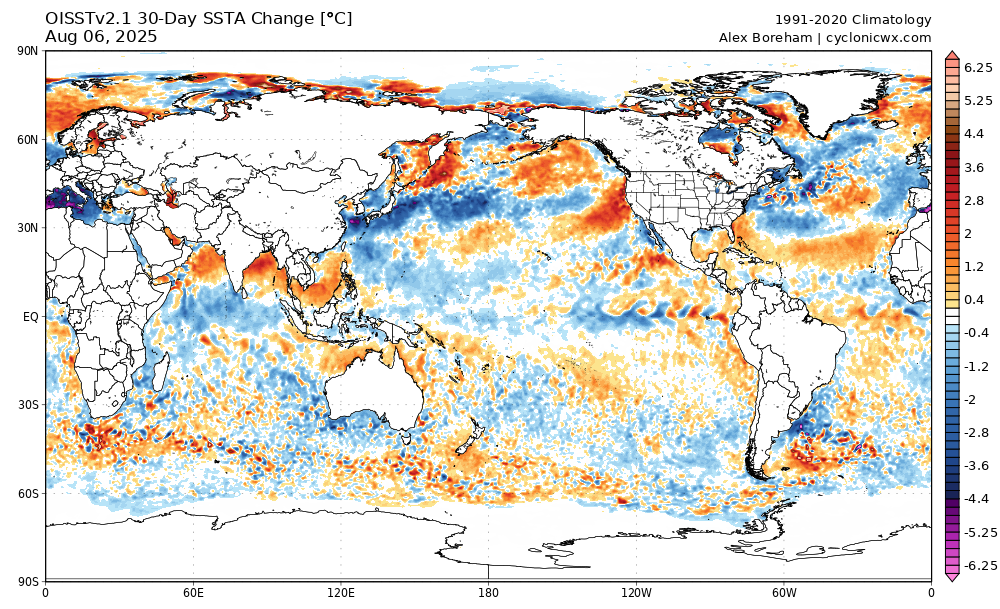
Looking at the 30 day change, you may be stuck with cool piss if you don't hurry.