All Activity
- Past hour
-

E PA/NJ/DE Summer 2025 Obs/Discussion
ChescoWx replied to Hurricane Agnes's topic in Philadelphia Region
This morning was our chilliest morning of the late summer/early fall season. Many of the area lower valley spots fell into the mid to upper 40's including Warwick Township at 45.9 / Nottingham 47.0 / Avondale 49.5 / Kennett Square 48.7 / West Bradford 47.8. The higher ridge locations stayed in the lower 50's. We should see a repeat with similar temperatures tonight. Our below normal temperatures will continue through the week and into next week. The "mildest" day looks to be tomorrow, but it will still feature temperatures still several degrees below normal for the end of August. Another cold front crosses the area tomorrow night and we should again see nights in the 40's for those valley locations both Saturday and Sunday morning. Only a very slight chance of a shower on Friday otherwise another dry week in what has been one of our driest August months on record.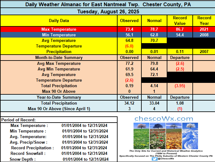
-

Central PA Summer 2025
Mount Joy Snowman replied to Voyager's topic in Upstate New York/Pennsylvania
Could be wrong but I believe we have our first "official" reading in the 30s for Pennsylvania, as BFD hit 37 last night. -
Thanks Mount Joy!!
-

September 2025 OBS-Discussion centered NYC subforum
wdrag replied to wdrag's topic in New York City Metro
fwiw...5H pattern is looking interesting for me here as of the 06z/27 ensembles. my interest is west of I95 where it's been pretty darn dry since the 22nd. Am I seeing opportunity for for 1/2-2" of rain in nw NJ next week beginning periodically Monday night Sept 1? -
Sept thread started... this above added to Sept.
-
Canaan is a relatively short drive for me so when my Dad was visiting this weekend, we drove by there and mentioned how us weather nerds follow their temps like gospel. Interesting that today, it's the coldest in the country. Even for a guy who couldn't care less about weather, he finds it fascinating that a locale near us can be that cold. Wish I could have a cabin smack in the middle of it.
-
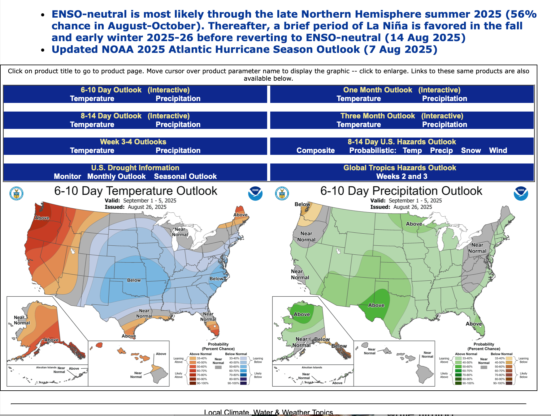
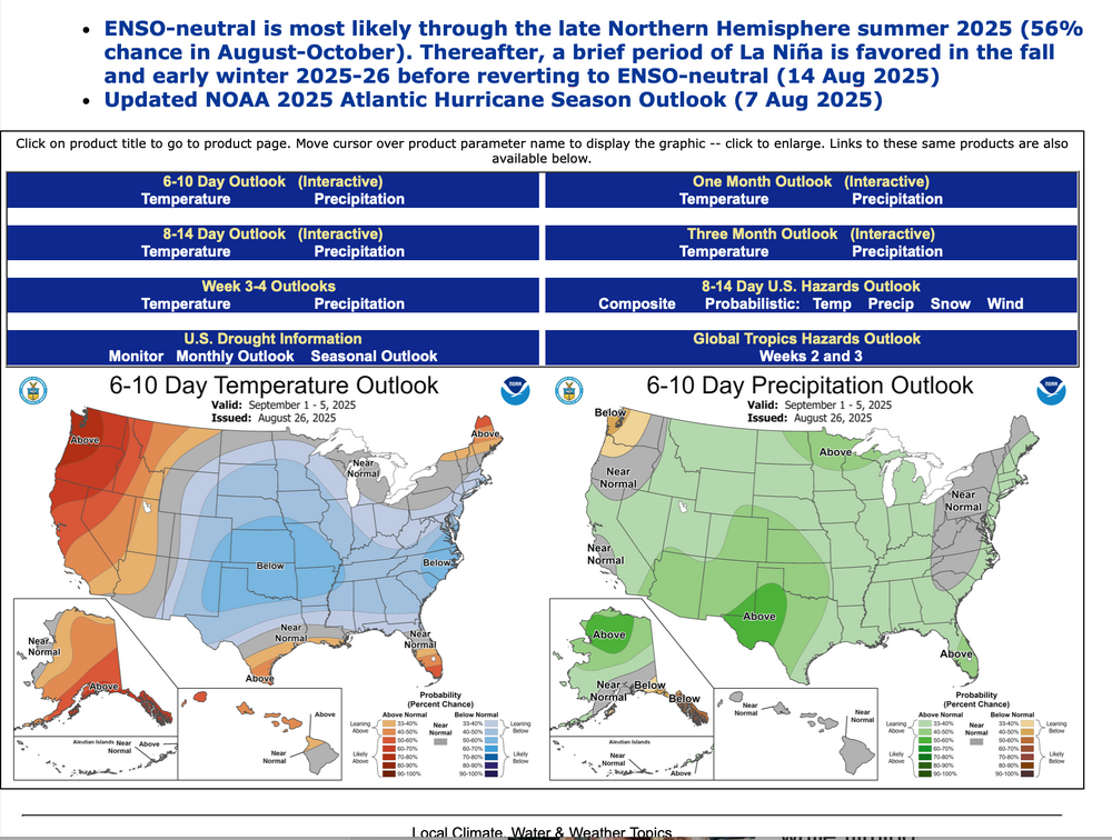
Am not using GEFS predictors etc beyond 2 weeks and messing up the anticipation mid month onward, like the August 2025 post. Instead I've added the 6-10 day issued yesterday, as well as the page you can go to look at CPC's daily updates of 6-10, 8-14 day, the weekly Friday updates of the 2-3 week and twice monthly updates of the monthly outlook, as well as other occasionally helpful predictors, based on the still nascent developing long ranging science beyond 2 weeks. https://www.cpc.ncep.noaa.gov
-
 where was all this lowposting when we were breaking records last month
 -
Yeah, late seasons have been very active since Sandy back in 2012.
-
 Picked up .20" rainfall last night about 9:00 in a quick moving but heavy shower. Very localized and went right overhead. Little or nothing within 1/2 mile of here. Loving the cool weather. Windows open and a/c off. JCP&L is sad.
-
If all goes well I'll get Sept thread started by 8PM. fwiw...5H pattern is looking interesting for me here, west of I95 where it's been pretty darn dry since the 22nd. Am I seeing opportunity for for 1/2-2" of rain in nw NJ next week beginning periodically Monday night?
-

Mid to long range discussion- 2025
WinstonSalemArlington replied to wncsnow's topic in Southeastern States
An even deeper chill about ten days away? -
 I saw Somerville was 49 this morning, their first 40s I believe. I made it to 52. Should be great weather later for the System of a Down concert.
 -
The site isn't even a year old yet so no records available.
-
Most of my rain for this summer came within 6 hours on two days.
-
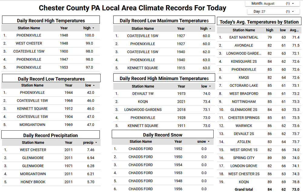
 Newark has averaged 3 days reaching 90° after August since 2010. Monthly Number of Days Max Temperature >= 90 for NEWARK LIBERTY INTL AP, NJ Sep-Oct Click column heading to sort ascending, click again to sort descending. Mean 3 0 3 2024 0 0 0 2023 6 0 6 2022 1 0 1 2021 1 0 1 2020 0 0 0 2019 3 1 4 2018 4 0 4 2017 3 0 3 2016 5 0 5 2015 5 0 5 2014 3 0 3 2013 1 0 1 2012 2 0 2 2011 0 0 0 2010 6 0 6
 -
When I was 10-11 yr old, I'd pull poison ivy vines off of trees and out of the ground as it had no effect on me. Then I read that one could suddenly become susceptible and decided to be a bit more careful. I got a very mild P.I. rash about a dozen years ago, but only after spending the morning pulling plants from the embankment behind the church parking lot - filled a 30-gallon garbage bag. Another crisp autumnal day that started in the 40s.
-
Friday has always been just a cold front?
- Today
-
Yeah euro has had a big mid/long range warm bias the last month. I’m sure that will start verifying in time for winter lol
-
 The 95 last year was the one day at 90 plus in the period as was the 91 in 2023, same in 2019, 19th at EWR. There have been a few with no or one/two days of 90s of late in the period. We'll see if we can nudge 1 - 3 more in Sep.Oct.
 -

O'Brother Septorcher
Prismshine Productions replied to Prismshine Productions's topic in New England
Ouch... All 3 ens means only average to about an inch of rain over the next two weeks Sent from my SM-S166V using Tapatalk -
Friday just reminds me of one of those 'clippers' we get in modern winters that starts out further south in the long range, but eventually ends up north of the St Lawrence river . meh
-
Euro Skynet is meh. So we meh for now
-
This really topped off this beautiful month. https://vm.tiktok.com/ZTHGT7mffUucj-2N0CI/
.thumb.JPG.418e8a9a2902ae687ec35ff4bc0e038e.JPG)