All Activity
- Past hour
-

New Years Day 2026 - 1st snows of the new year possible
CoastalWx replied to Baroclinic Zone's topic in New England
Looks like Ginxy area and cape jack. Brett in sucker hole -
2 times I've seen 4"+ in an hour in our region, 1/26/11 and the first 2/10 storm.
-
Wow, big gains over the last two days. Almost wonder if the wind wasn't messing with algorithm. Now just 1% below the 52-year average.
-

January 2026 regional war/obs/disco thread
40/70 Benchmark replied to Baroclinic Zone's topic in New England
The loss of the big early Jan NAO jives more with my seasonal idea...that said, I'm def. still going to be too warm in January. -

New Years Day 2026 - 1st snows of the new year possible
Damage In Tolland replied to Baroclinic Zone's topic in New England
That’s what she said? -
I believe we pushed close to those rates in the first Feb storm on 2010
-
I’ve experienced one just SE of dunkirk where we got 3 ft, it was great. But that was a long time ago and memories are fading. I want more haha
-
Excellent succinct summary! But there’s a typo as you meant Jan of 1976 as opposed to 1977. Also, Jan of 1975 phase 6 was almost as cold. By the way, I calculated the anoms based on GSP because that was near the center of BAM map’s coldest. Other areas would vary of course. I’d still much rather have moderate to weak 8-1-2 as I said for the E US as a whole.
-
After a low of 24° this AM, every day in December has had a low of 32° or lower imby. Crazy stat - not sure when the last time a whole month would have lower minimums… maybe Feb 2015?
-

January 2026 regional war/obs/disco thread
WinterWolf replied to Baroclinic Zone's topic in New England
Been pretty good here so far. Happy new year. -
New Years Day 2026 - 1st snows of the new year possible
WinterWolf replied to Baroclinic Zone's topic in New England
According to them, this thing isn’t as dry as we were thinking it was. Hmm. -
If you never experienced it ya you got to do it. It makes our 20” in 18hrs storms look like nothing.
-

January 2026 regional war/obs/disco thread
TauntonBlizzard2013 replied to Baroclinic Zone's topic in New England
when it’s bad, it’s bad. -
New Years Day 2026 - 1st snows of the new year possible
TauntonBlizzard2013 replied to Baroclinic Zone's topic in New England
Enjoy your C-1” it’s all ya got -
New Years Day 2026 - 1st snows of the new year possible
Damage In Tolland replied to Baroclinic Zone's topic in New England
Here’s why they expanded. We’ll see if it works or not. expanded the Winter Weather Advisory to include; western zones of Franklin and Hampshire Counties, Worcester County, Tolland and Windham Counties, most of Rhode Island, and all of southeast Massachusetts. Here we feel there is the best potential for 2-4" with the higher of the totals on the western facing hills, due to upsloping from the southwest flow. Forecast Details: Quiet through the rest of the daylight hours, then a robust 850mb shortwave races through southern New England this evening through early tomorrow morning. This feature has near normal moisture to work with, PWATs of 0.3" to 0.4" doesn`t sound overly too impressive, but is enough to work with. Looking through BUFKIT forecast soundings, there is good saturation and OMEGA/lift in the dendritic growth zone (DGZ), with light to moderate snow for several hours 2am to 6am. HREF supportive of this idea, with probabilities between 30% and 60% for snowfall rates 1+" an hour during this time across Connecticut, Rhode Island, and southeast Massachusetts. As mentioned above, those traveling late tonight or tomorrow morning will want to plan accordingly as slick travel is expected. There is a level of uncertainty around how far north the warm air reaches, for the time being confidence for the northern extent is Nantucket. It is there the best chance for rain to mix with the snow. Elsewhere, remains cold enough to stay snow. Additionally, southwest flow enhances snow potential due to orographic lift/upslope along western facing hills of northeastern Connecticut, central Massachusetts... even western hills of Rhode Island benefit from an upslope component. Finally, the shortwave moves off shore early Thursday morning, followed with an Arctic front midmorning, with additional snow showers or possibly snow squalls. -
I am envious. When the kids are older, we’ll chase Blackwater, wisp, and tug hill are good go-tos.
-

E PA/NJ/DE Winter 2025-26 Obs/Discussion
Kevin Reilly replied to LVblizzard's topic in Philadelphia Region
That is actually fairly impressive. I guess I will have to set my alarm clock. -
New Years Day 2026 - 1st snows of the new year possible
Damage In Tolland replied to Baroclinic Zone's topic in New England
Yeah I recall that one too. I think there were two snowfalls that same week -
Thanks for that info. I was having a hard time reconciling what look like really cold maps with that phase. I know there are times when the MJO has less influence.
-
Then we would piss and moan because the pattern would change for a decade and our home bases would have 300% normal snow for years and -90% at Hamburg
-

Winter 2025-26 Medium/Long Range Discussion
Frog Town replied to michsnowfreak's topic in Lakes/Ohio Valley
Exactly! -

New Years Day 2026 - 1st snows of the new year possible
WxWatcher007 replied to Baroclinic Zone's topic in New England
At least in that one I came away with something. -
AKA the Irish Hills, yes. I believe it affects our storms in the Summer and snow in the Winter. More anecdotal, but other Mets have commented on it.
-

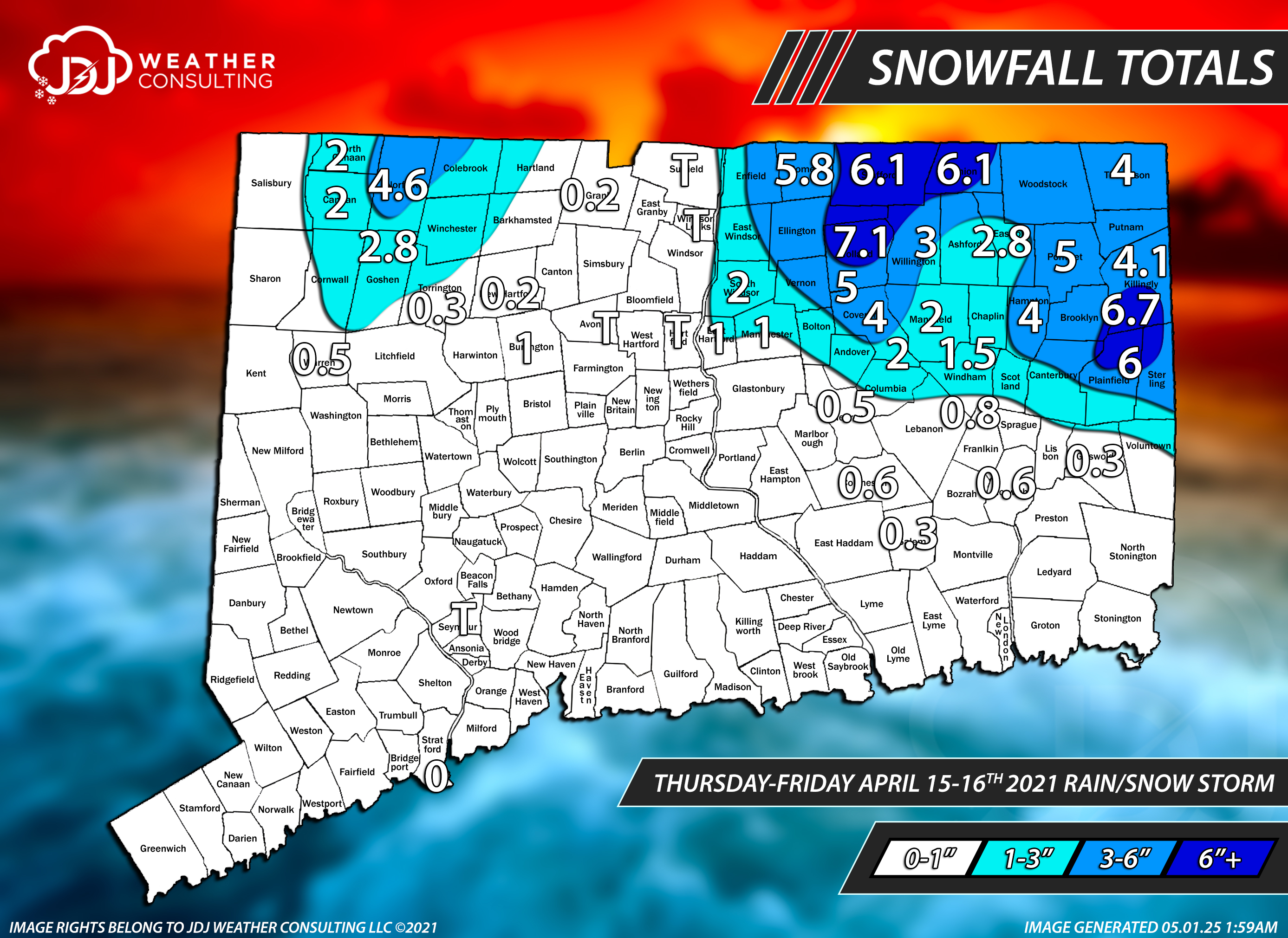
New Years Day 2026 - 1st snows of the new year possible
The 4 Seasons replied to Baroclinic Zone's topic in New England
April 2021 was also a E/NE special above 500ft or so. But wasn't localized to just tolland county as a lot of the worcester hills did well and berkshires. https://www.jdjweatherconsulting.com/apr-15-16-2021
-

New Years Day 2026 - 1st snows of the new year possible
UnitedWx replied to Baroclinic Zone's topic in New England
I always forget about the real tree thing. I've been running vintage artificial trees for years. You should look into one of the early 60s aluminum trees, it makes the living room look like an ice storm has passed through