All Activity
- Past hour
-
Ouch
-

July 2025 Obs/Disco ... possible historic month for heat
Cyclone-68 replied to Typhoon Tip's topic in New England
What a disappointment today. I didn’t predict I’d get a tstorm one but except from 1:30 to 3:30 today it was a complete no show everywhere. In other words I thought they’re might have been a few more around -
Cell just popped up out of nowhere. It is raining!
-

July 2025 Obs/Disco ... possible historic month for heat
RUNNAWAYICEBERG replied to Typhoon Tip's topic in New England
Dews in Aug?…no way. - Yesterday
-

2025 Spring/Summer Mountain Thread
Maggie Valley Steve replied to Maggie Valley Steve's topic in Southeastern States
I've been under two wet cells this afternoon that has brought over an inch of rain and still raining. Luck of the draw today I suppose. -

July 2025 Obs/Disco ... possible historic month for heat
radarman replied to Typhoon Tip's topic in New England
Missed the strong stuff but caught 2 little pop up storms. Raining now along the boundary -

July 2025 Obs/Disco ... possible historic month for heat
ineedsnow replied to Typhoon Tip's topic in New England
540 line making it to northern Maine with temps in the upper 30s were getting there
-
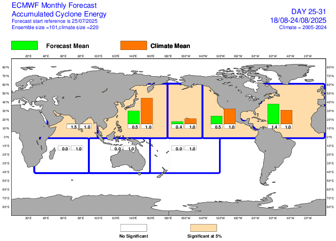
Euro Weeklies ACE for August 18-24 up to 140% of 2005-24 avg. Edit: Also note the green box in ATL is now larger than even the WPAC green box:
-
At least it isn’t a Herculean feat to even get a thunderstorm where you live. It’s like nighttime complexes no longer exist here in West Michigan when they used to be like 80% of our summer precip. This year in particular the main EW frontal zone is either over the Upper Peninsula, or it’s down in Illinois/ Indiana. The transition is a single day, and of course storms fail to fire over Lake Michigan and only get going once the front has passed to the southeast. We also never get those 40 kt low level jets aimed at Michigan these days. They pump moisture at Minnesota, Northern Wisconsin, and even the UP for days, but fizzle to nothing whenever the boundary sinks south into my area.
-
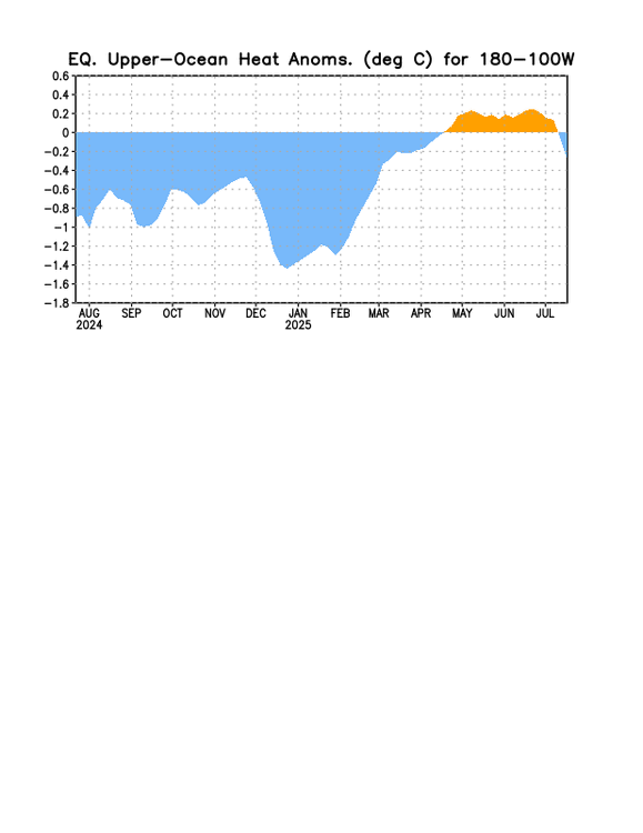
OHC plunge continues:
-

July 2025 Obs/Disco ... possible historic month for heat
kdxken replied to Typhoon Tip's topic in New England
Said no model ever. -
Eyeing those storms in Carroll and BaltCo warily…
-
Absolutely horrible forecast for my area:GAZ118-260500- INLAND CHATHAM- INCLUDING THE CITIES OF GARDEN CITY, POOLER, AND SAVANNAH 549 PM EDT FRI JUL 25 2025 ...HEAT ADVISORY IN EFFECT FROM 10 AM SATURDAY TO 10 AM EDT SUNDAY... ...EXTREME HEAT WATCH IN EFFECT FROM SUNDAY MORNING THROUGH MONDAY EVENING... TONIGHT MOSTLY CLEAR. LOWS IN THE UPPER 70S. SOUTH WINDS 5 TO 10 MPH, BECOMING SOUTHWEST AFTER MIDNIGHT. SATURDAY SUNNY. HIGHS IN THE UPPER 90S. HEAT INDEX VALUES UP TO 112. WEST WINDS AROUND 5 MPH.SATURDAY NIGHT MOSTLY CLEAR. LOWS IN THE UPPER 70S. SOUTHWEST WINDS AROUND 5 MPH. SUNDAY SUNNY, HOT WITH HIGHS AROUND 101. NORTHWEST WINDS AROUND 5 MPH. HEAT INDEX VALUES UP TO 113. SUNDAY NIGHT MOSTLY CLEAR. LOWS AROUND 80. SOUTHWEST WINDS AROUND 5 MPH. HEAT INDEX VALUES UP TO 106 EARLY IN THE EVENING. MONDAY SUNNY WITH A SLIGHT CHANCE OF SHOWERS AND THUNDERSTORMS. HOT WITH HIGHS AROUND 100. CHANCE OF RAIN 20 PERCENT. HEAT INDEX VALUES UP TO 115. MONDAY NIGHT PARTLY CLOUDY WITH A SLIGHT CHANCE OF SHOWERS AND THUNDERSTORMS. LOWS IN THE UPPER 70S. CHANCE OF RAIN 20 PERCENT. HEAT INDEX VALUES UP TO 105 EARLY IN THE EVENING. TUESDAY MOSTLY SUNNY WITH A CHANCE OF SHOWERS AND THUNDERSTORMS. HIGHS IN THE MID 90S. CHANCE OF RAIN 50 PERCENT. HEAT INDEX VALUES UP TO 115.
-

July 2025 Obs/Disco ... possible historic month for heat
Torch Tiger replied to Typhoon Tip's topic in New England
Hoping for a quintessential August, unrelenting dank dews with few breaks -

July 2025 Obs/Disco ... possible historic month for heat
Damage In Tolland replied to Typhoon Tip's topic in New England
Do not understand what the 3 amigo crew of ACATT is seeing with dry cool month . We are acknowledging the first 3-5 days . After that. It’s back to tonight -

July 2025 Discussion-OBS - seasonable summer variability
WestBabylonWeather replied to wdrag's topic in New York City Metro
Typical summer storms in and out. -
July 2025 Obs/Disco ... possible historic month for heat
Torch Tiger replied to Typhoon Tip's topic in New England
yeah there's lots of dews on the horizon, hopefully those annoying airmasses continue to modulate warm on models as we go forward -
I saved this the other day, #1 hottest 30-day period for New York
-
 5H Trough generally in the eastern half of the USA this month with a strong ridge in the Rockies, possibly shifting west? Tropics eventually should get going... but impact up here in the NYC subforum unknown to this poster.
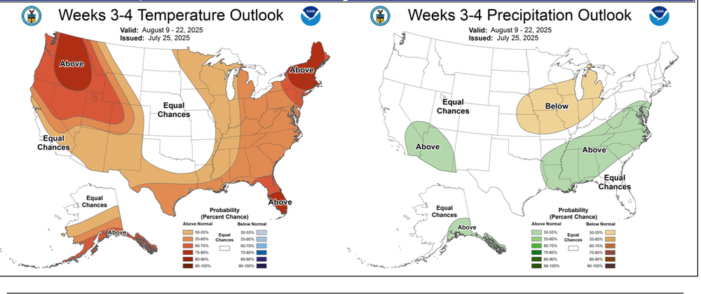
-

2025-2026 ENSO
so_whats_happening replied to 40/70 Benchmark's topic in Weather Forecasting and Discussion
Amazing no one likes to comment on thoughts and actually have a conversation in this thread it is either arguments or silence. i still see why raindance has essentially stopped posting. -

July 2025 Discussion-OBS - seasonable summer variability
NorthShoreWx replied to wdrag's topic in New York City Metro
I'm not sure what his side duties may have included, but he was responsible for the horses. -
Very sorry for your loss. Reading this made me sad, but also happy that there are people like your dad in the world.
-
Yip, between early this morning (literally one cell out of nowhere just like yesterday morning) and this afternoon we picked up another half inch or so. I was in New Castle and Chesterfield yesterday afternoon, cumulus back building from OH but no rain and when I got home around 8pm there were puddles everywhere. Between the one yesterday morning and early evening nearly a half inch. It's been like this everyday. I've lived around sea breezes and such, all that crap. When I look at Sat pics of central Indiana theres more often than not a thin stripe of clouds building in this area lately. Like I said, almost as if a latent outflow boundary has nestled in here. There were some studies back in the 90's concerning this type of phenomena and hurricane tracks but that was more centered on where the seasonal steering ridges were setting up as they can fluctuate a great deal. They were looking at correlations of early season moisture transport from Gulf and Atlantic, where heavier rains were occurring, that could show subtle areas of where say the Bermuda high was setting up that could give them clues as to where landfalling storms may be more prevalent for the coming Summer/Fall. I remember Bob Sheets discussing "follow the moisture" when referring to this. Had it bookmarked eons ago cant find it. Probably barking up the wrong tree. I mean we have had a meandering boundary through here for about a month with nothing major shoving it about. Was just wondering if such a thing may or not exist even theoretically. Like a little atmospheric wrinkle thats just floating around awaiting a 50 degree dew dry line to sweep in (or is that me lol) Plus I'm bored, freakin' sauna outside now
-
 Been just gross since the little rain that fell hours ago.
 -

July 2025 Obs/Disco ... possible historic month for heat
weatherwiz replied to Typhoon Tip's topic in New England
15% chance of seeing a damaging wind event within 25 miles of any point…based on the storm reports I’d say the slight verified