All Activity
- Past hour
-

“Cory’s in NYC! Let’s HECS!” Feb. 22-24 Disco
40/70 Benchmark replied to TheSnowman's topic in New England
It's easier to not have "nerves" when you don't put yourself out there with a map. I'm not trying to sound like an ass, but if you bother to put a lot of time into something like this, it' either 1) You depend on it for your livelihood ...and/or 2" Are extremely passionate about it and want to hone and display your understanding by putting forth a quality map. -

2/22-23 "There's no way..." Storm Part 2
AmericanWxFreak replied to Maestrobjwa's topic in Mid Atlantic
Sorry, just tried to post the new map a single time. My Tapatalk is glitching out. . -

“Cory’s in NYC! Let’s HECS!” Feb. 22-24 Disco
TauntonBlizzard2013 replied to TheSnowman's topic in New England
What’s the euro qpf? -

2/22-23 "There's no way..." Storm Part 2
DDweatherman replied to Maestrobjwa's topic in Mid Atlantic
That was a sweet run man. That’s what I’m saying, maybe it does what mill said it should and kick NNE more than ENE and gets a bit wetter. I’ll take the exact h5 on 18z leading in and bet we get a beefier set of maps. -

The February 22-23 Late Season Miracle: JV Disco/Banter Thread
mappy replied to bncho's topic in Mid Atlantic
lol not a possibility. He’s been snipped for a while -
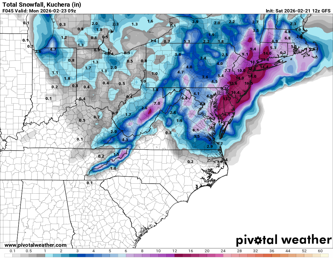
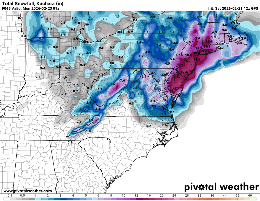
Snow map for euro ?
-
Oddly enough the euro bombs the low deeper than the NAM.
-
just talked to the mail lady. i said i guess no mail monday, she said probably there will be because we're not getting much here, its all down the shore...i told her she is wrong, and that this area might as well be coastal...middlesex co near the bay. systems like this one usually deliver; unless the bands shift east before getting here and this doesn't look like that....she told me i'm negative and to think positive, and we won't get snow.....told her i'd see her wednesday.....
-

February 22-23 Storm Thread/OBS
PhiEaglesfan712 replied to Mikeymac5306's topic in Philadelphia Region
Can see that happening. If that does happen, I could see 12-20 inches as far west as the I-95 metro area. -
Euro still correcting west. Good jump.
-
Euro and NAM/GFS solutions will meet somewhere in the middle
-

Richmond Metro/Hampton Roads Area Discussion
ORFDawg2013 replied to RIC Airport's topic in Mid Atlantic
-
Still not showing the really big totals but the fact it expanded warning level snow way inland is a good sign.
-

2/22-23 "There's no way..." Storm Part 2
stormtracker replied to Maestrobjwa's topic in Mid Atlantic
Monday -
craig allen calling for 12-18 for the city and the coast..
-

Central PA Winter 25/26 Discussion and Obs
AccuChris replied to MAG5035's topic in Upstate New York/Pennsylvania
12z Euro a good bit west from its prior run . -

“Cory’s in NYC! Let’s HECS!” Feb. 22-24 Disco
Damage In Tolland replied to TheSnowman's topic in New England
Why does anyone care what Euro shows? It didn’t have the storm 2 days ago. Who cares -

Central PA Winter 25/26 Discussion and Obs
GrandmasterB replied to MAG5035's topic in Upstate New York/Pennsylvania
Stolen from MA. Blizz probably has better maps for us.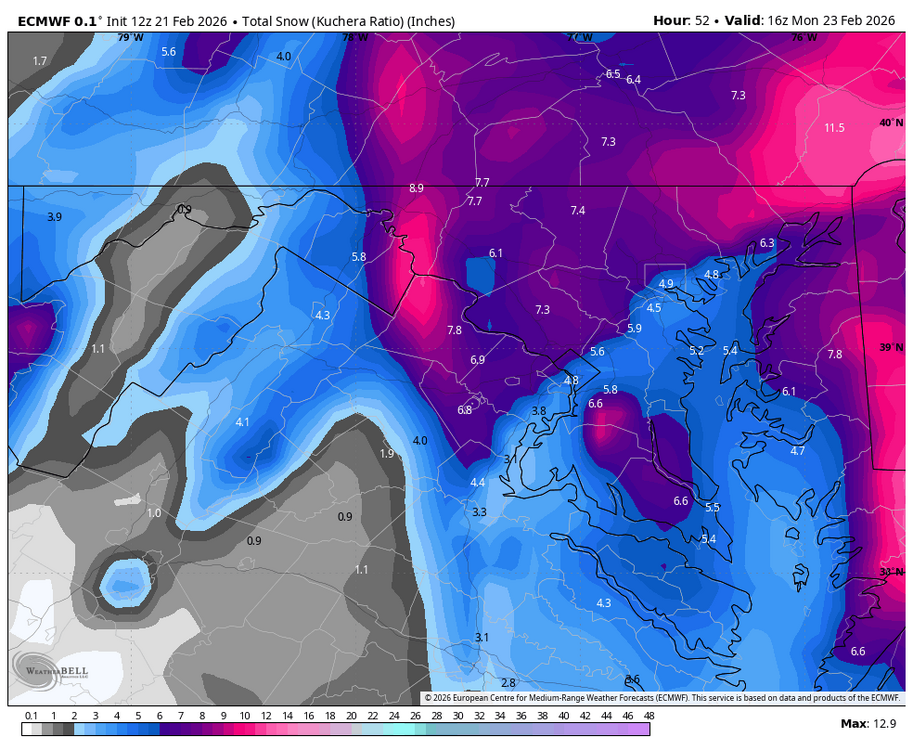
-

Central PA Winter 25/26 Discussion and Obs
Superstorm replied to MAG5035's topic in Upstate New York/Pennsylvania
Euro west . -
2/22-23 "There's no way..." Storm Part 2
AmericanWxFreak replied to Maestrobjwa's topic in Mid Atlantic
. -
Keep it coming!
-

“Cory’s in NYC! Let’s HECS!” Feb. 22-24 Disco
Cyclone-68 replied to TheSnowman's topic in New England
Might have to archive this: Sunday Night Snow, mainly after 7pm. The snow could be heavy at times. Patchy fog after midnight. Areas of freezing fog after 5am. Low around 23. Blustery, with a northeast wind 9 to 14 mph increasing to 17 to 22 mph after midnight. Winds could gust as high as 40 mph. Chance of precipitation is 100%. New snow accumulation of 3 to 7 inches possible. Monday Snow. The snow could be heavy at times. High near 33. Windy, with a north wind 22 to 26 mph, with gusts as high as 48 mph. Chance of precipitation is 100%. New snow accumulation of 10 to 16 inches possible. Monday Night Snow likely, mainly before 1am. The snow could be heavy at times. Mostly cloudy, with a low around 17. Northwest wind 10 to 16 mph, with gusts as high as 32 mph. Chance of precipitation is 70%. New snow accumulation of 1 to 3 inches possible. -
ECMWF definitely folded and the 5H progression is great through 00z, then it kicks east-northeast instead of north-northeast like it should on the capture. It's coming into better alignment with other guidance like the GFS and hi-res. It's still a little too dry overall considering the setup, but it's a big shift in the grand scheme and a final fold to how this will materialize. QPF is going to be tough with this one. Our forecast should be on the website now and it's a very sharp gradient from Easton to DC with more east. It's plausible it's too light, but there will be adjustments tonight. Still a general 3-6" for a lot of the region with 5-10" across the M/D from Carroll on east. The norlun trough is a stripe of 6-10" now. That setup is delicate. Updated forecast will be out later.
-

“Cory’s in NYC! Let’s HECS!” Feb. 22-24 Disco
ORH_wxman replied to TheSnowman's topic in New England
Prob a Cape to SE MA/RI jackpot on that run. Still an impressive look though overall but not quite as crazy as 06z. -
2/21 12z Euro Total QPF 2/22 - 2/23-24 Snow 10:!